geocat.ch
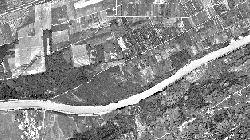
DinoImage
Mosaïque d'orthophotos de 1938 à 1942 de la plaine du Rhône entre Brigue et Le Bouveret.
Simple
- Alternate title
-
DinoImage
- Date (Creation)
- 2011-08-03
- Identifier
- 211
- Purpose
-
Le mosaïque d'orthophotos a été constitué pour avoir une couverture complète de la plaine du Rhône autour des années 40.
- Status
- Completed
Custodian
- Spatial representation type
- Grid
Spatial resolution
- Spatial resolution
- 0.25 m
Spatial resolution
Equivalent scale
- Denominator
- 10000
- Topic category
-
- A Imagery base maps earth cover
Extent
Extent
- Description
-
Canton of Valais (VS)
))

- Maintenance and update frequency
- Not planned
Resource format
- Title
-
Tagged Image File Format (TIFF)
- Date
- GEMET - INSPIRE themes, version 1.0
-
-
Orthoimagery
-
- GEMET
-
-
history
-
- geocat.ch
-
-
official geodata
-
Resource constraints
- Use limitation
-
Aucunes
Resource constraints
- Access constraints
- Other restrictions
- Other constraints
-
Géodonnées accessibles au public (niveau A selon l'OGéo)
- Other constraints
-
Les conditions générales d'utilisation des géodonnées du Canton du Valais font foi ( https://www.vs.ch/fr/web/guest/information-legale).
- Language
- Français
- Character encoding
- UTF8
- Environment description
-
S:\Géodonnées VS\A3 Images\DinoImage 1938.lyr, S:\Géodonnées VS\A3 Images\DinoImage 1938 Index.lyr
- Subtopic Category
- A3 Aerial and Satellite Imagery
- Basic Geodata
- false
- Basic Geodata Legal Level
- Cantonal
- Basic Geodata Type
- Reference Geodata
- Distribution format
-
-
GeoTIFF (GEOTIFF)
-
Cloud Optimized GeoTIFF (TIFF / TIF)
-
Distributor
- Statement
-
Photos aériennes analogues de Swisstopo
- Hierarchy level
- Dataset
- Description
-
Scannage et orthorectification
- Reference system identifier
- EPSG:2056/CH1903+_MN95
Metadata
- Metadata identifier
- f3c24fcc-fcf1-4f00-9c5b-e2e817a9e866
- Language
- Français
- Character encoding
- UTF8
- Language
- Deutsch
- Character encoding
- UTF8
- Language
- Italiano
- Character encoding
- UTF8
- Language
- English
- Character encoding
- UTF8
- Language
- Rumantsch
- Character encoding
- UTF8
Distributor
Type of resource
- Resource scope
- Dataset
- Metadata linkage
-
https://www.geocat.ch/geonetwork/srv/api/records/f3c24fcc-fcf1-4f00-9c5b-e2e817a9e866
- Date info (Creation)
- 2016-08-23T12:14:06Z
- Date info (Revision)
- 2026-05-18T12:03:24.533527Z
Metadata standard
- Title
-
eCH-0271