Limites communales - Archives
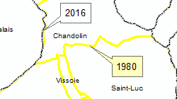
Communes valaisannes 1970/1980/1990/2000/2005/2007-2024
Simple
Identification info
- Alternate title
-
Communes - Archives
- Date (Creation)
- 1970-01-01
- Date (Revision)
- 2024-12-31
- Citation identifier
- 385
Cited responsible party
Responsible party
- Organisation name
-
Kanton Wallis - Dienststelle für Geoinformation (DGI) - Amt für Geomatik
- Position name
-
Amt für Geomatik
- Voice
-
+41 27 606 28 00
Address
- City
-
Sion
- Postal code
-
1950
- Country
-
CH
- Electronic mail address
-
mo@admin.vs mo@admin.vs.ch
- Streetname
-
Rue du Scex
- Streetnumber
-
4
- Protocol
-
WWW:LINK
- Role
- Custodian
- Organisation Acronym
-
Service de la géoinformation (SGI)
- Purpose
-
Les données ont été constituées principalement pour établir des cartes chloroplètes en fonction des communes
- Status
- Historical archive
Point of contact
Responsible party
- Organisation name
-
Kanton Wallis - Dienststelle für Geoinformation (DGI) - Amt für Geomatik
- Position name
-
Amt für Geomatik
- Voice
-
+41 27 606 28 00
Address
- City
-
Sion
- Postal code
-
1950
- Country
-
CH
- Electronic mail address
-
mo@admin.vs mo@admin.vs.ch
- Streetname
-
Rue du Scex
- Streetnumber
-
4
- Protocol
-
WWW:LINK
- Role
- Custodian
- Organisation Acronym
-
Service de la géoinformation (SGI)
- Maintenance and update frequency
- Annually
- Name
-
ESRI Enterprise Geodatabase
-
GEMET themes
-
-
administration
-
-
GEMET - INSPIRE themes, version 1.0
-
-
Geographical names
-
Administrative units
-
-
GEMET
-
-
municipality
-
administrative boundary
-
- Use limitation
-
Aucunes
- Access constraints
- Other restrictions
- Other constraints
-
Géodonnées accessibles au public (niveau A selon l'OGéo)
- Other constraints
-
Les conditions générales d'utilisation des géodonnées du Canton du Valais font foi ( https://www.vs.ch/fr/web/guest/information-legale).
- Spatial representation type
- Vector
- Denominator
- 10000
- Language
- Français
- Character set
- UTF8
- Topic category
-
- D Political and Administrative Boundaries
- Environment description
-
S:\Géodonnées VS\D Limites\Limites communales - Archives\
Extent
- Description
-
Canton of Valais (VS)
))

- Distribution format
-
-
ESRI Shapefile (SHP)
()
-
autres formats sur demande / andere Formate auf Anfrage
(
-
)
-
ESRI Shapefile (SHP)
()
Distributor contact
Responsible party
- Organisation name
-
Kanton Wallis - Dienststelle für Geoinformation (DGI) - CC GEO
- Position name
-
CC GEO
- Voice
-
+41 27 606 28 00
Address
- City
-
Sion
- Postal code
-
1950
- Country
-
CH
- Electronic mail address
-
sitvs@admin.vs sitvs@admin.vs.ch
- Streetname
-
Rue du Scex
- Streetnumber
-
4
- Protocol
-
WWW:LINK
- Role
- Distributor
- Organisation Acronym
-
Dienststelle für Geoinformation (DGI)
- Hierarchy level
- Dataset
- Statement
-
Les limites communales digitalisés à partir du plan d'ensemble au 1:10'000 ont été remplacées par les limites provenant de la mensuration officielle. Cette couche évolue en fonction de l'état d'avancement de la mensuration officielle.
- Description
-
digitalisation. Adaptation au parcellaire pour les communes au standard MO93.
- Geometric object type
- Surface
- Geometric object count
- 129
- Reference system identifier
- EPSG:2056 / CH1903+_MN95
Content Information
- Included with dataset
- Date (Creation)
- 2009-07-01
- Model type
- Feature description
Content Information
- Included with dataset
- Date (Creation)
- 2009-07-01
- Model type
- INTERLIS 1
Metadata
- Metadata language
- Français
- Character set
- UTF8
- Hierarchy level
- Dataset
- Date stamp
- 2025-01-24T12:44:29.788Z
- Metadata standard name
-
GM03 2+
Metadata author
Responsible party
- Organisation name
-
Kanton Wallis - Dienststelle für Geoinformation (DGI) - CC GEO
- Position name
-
CC GEO
- Voice
-
+41 27 606 28 00
Address
- City
-
Sion
- Postal code
-
1950
- Country
-
CH
- Electronic mail address
-
sitvs@admin.vs sitvs@admin.vs.ch
- Streetname
-
Rue du Scex
- Streetnumber
-
4
- Protocol
-
WWW:LINK
- Role
- Distributor
- Organisation Acronym
-
Dienststelle für Geoinformation (DGI)
 geocat.ch


