geocat.ch
Aeronautical Chart ICAO Switzerland 1:500'000
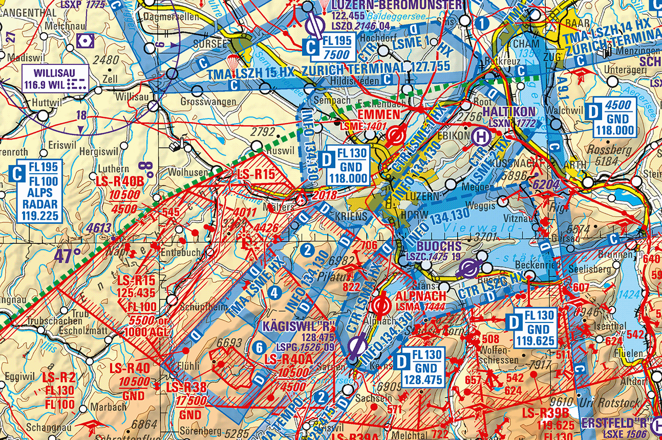
The official Aeronautical Chart ICAO 1:500'000 of Switzerland is published in cooperation with skyguide. The chart includes airports and airfields, classified air space, restricted and hazardous areas as well as air navigation obstacles. The printed chart is available folded. There are air traffic control information and an index of airport radio frequencies included in this product. The map is normally annually revised. The pixel chart is delivered as a georeferenced TIF-file (raster format). The chart content is available either as a colour combination or seperated in 3 thematic colour layers (basic map, airspace/air traffic control information, air navigation obstacles/transmission lines), in a resolution of 254 dpi.
Simple
- Alternate title
-
Aeronautical Chart ICAO
- Date (Revision)
- 2026-03-19
- Date (Creation)
- 1976-01-01T00:00:00
- Identifier
- ch.bazl.luftfahrtkarten-icao
- Presentation form
- Digital map
- Presentation form
- Hardcopy map
- Purpose
-
Geobasisdaten des Bundesrechts
- Status
- On going
Publisher
Point of contact
- Hours of service
-
07h45 - 11h45 / 13h30 - 17h00
Owner
specialistAuthority
- Spatial representation type
- paperMap
- Spatial representation type
- Grid
Spatial resolution
Equivalent scale
- Denominator
- 500000
- Topic category
-
- P Transportation
Extent
Extent
- Description
-
Aeronautical Chart ICAO 1:500'000
- Geographic identifier
- ICAO
))

- Maintenance and update frequency
- Annually
- Duration of Conservation
- 275
- Appraisal of Archival Value
- A
- Reason for Archiving Value
- Evidence of business practice
- geocat.ch
-
-
official geodata
-
air navigation
-
heliport
-
airfield
-
flight zone
-
Conservation and archiving planning AAP - Confederation
-
airspace
-
air traffic control
-
opendata.swiss
-
- GEMET
-
-
cartography
-
civil air traffic
-
air traffic
-
airport
-
- GEMET - INSPIRE themes, version 1.0
-
-
Transport networks
-
Elevation
-
- geocat.ch
-
-
FSDI Federal Spatial Data Infrastructure
-
Resource constraints
- Other constraints
- Opendata BY: Open use. Must provide the source.
Associated resource
- Title
-
Karten gemäss Luftfahrtrecht (Luftfahrtkarten)
- Association Type
- Reference to a master resource of which this one is a part
- Language
- Deutsch
- Character encoding
- UTF8
- Language
- Français
- Character encoding
- UTF8
- Language
- English
- Character encoding
- UTF8
- Basic Geodata
- true
- Basic Geodata ID
-
4.1
- Basic Geodata Legal Level
- Federal
- Distribution format
-
-
Tagged Image File Format (TIFF) Compressed LZW
-
analog
-
Distributor
- Hours of service
-
07h45 - 11h45 / 13h30 - 17h00
Distributor
Digital transfer options
- OnLine resource
-
Luftfahrtkarte ICAO Schweiz 1:500 000 Papier
Product information & shop Carta aeronautica OACI Svizzera 1:500 000 printed
Digital transfer options
- OnLine resource
-
ch.bazl.luftfahrtkarten-icao
WMS-FSDI service, layer "Aeronautical Chart ICAO"
Digital transfer options
- OnLine resource
-
ch.bazl.luftfahrtkarten-icao
WMTS-FSDI service, layer "Aeronautical Chart ICAO"
Digital transfer options
Digital transfer options
Digital transfer options
- OnLine resource
-
Vorschau auf map.geo.admin.ch
geo.admin.ch: the federal geoportal
- Statement
-
Based on the national map 1:500'000 and foreign maps.
- Hierarchy level
- Dataset
- Reference system identifier
- CH1903+
Metadata
- Metadata identifier
- f27432fa-948b-4608-98d5-22ebe118c98a
- Language
- Deutsch
- Character encoding
- UTF8
- Language
- Français
- Character encoding
- UTF8
- Language
- Italiano
- Character encoding
- UTF8
- Language
- English
- Character encoding
- UTF8
- Language
- Rumantsch
- Character encoding
- UTF8
Custodian
Type of resource
- Resource scope
- Dataset
- Metadata linkage
-
https://www.geocat.ch/geonetwork/srv/api/records/f27432fa-948b-4608-98d5-22ebe118c98a
- Date info (Creation)
- 2009-04-03T12:00:00Z
- Date info (Revision)
- 2026-04-13T09:24:00.022496Z
Metadata standard
- Title
-
ISO 19115-3