geocat.ch
Territorialdivisionen
Divisions territoriales
Divisione territoriali
Territorial divisions
Divisiuns territorialas
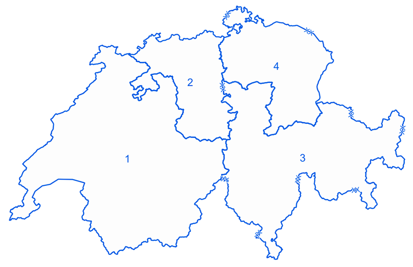
Die Territorialdivisionen (Ter Div) sind das Bindeglied zu den zivilen Behörden und gewährleisten die Zusammenarbeit zwischen der Armee und den Kantonen in ihren Räumen; sind grundsätzlich die Ansprechpartner für die zivilen Behörden bei Bedürfnissen zur Unterstützung durch die Armee; sind zuständig für die Führung von folgenden Leistungen innerhalb ihrer Räume: allgemeine Unterstützung (nicht polizeilicher Art), militärische Katastrophenhilfe im Inland und im grenznahen Ausland, Sicherungsaufgaben; können für Operationen/Einsätze eingesetzt werden und führen die unterstellten Verbände im Einsatz; stellen die Ausbildung und Führungsbereitschaft der kantonalen Territorialverbindungsstäbe (KTVS) sicher.
Les divisions territoriales (div ter) forment le trait d'union avec les autorités civiles et assurent la coopération avec les cantons. Elles sont le point de contact des autorités civiles lorsque ces dernières nécessitent l'appui de l'armée. De plus, les divisions territoriales conduisent les opérations/engagements de soutien et de sûreté ainsi que les engagements d'aide en cas de catastrophe à l'intérieur du pays et immédiatement au-delà de la frontière. Elles peuvent être engagées dans le cadres d'opérations/engagements et conduire les formations qui leur sont subordonnées à l'engagement. Elles portent la responsabilité de l'instruction et de la disponibilité à la conduite des états-majors de liaison cantonaux.
Le divisioni territoriali (div ter) sono l'elemento di collegamento con le autorità civili e assicurano la collaborazione tra l'esercito e i Cantoni nei rispettivi settori. Esse fungono da interlocutore con le autorità civili per quanto riguarda le richieste di sostegno da parte dell'esercito. A loro compete la condotta dei seguenti interventi all'interno dei propri settori: sostegno generale (non di polizia), nonché aiuto militare in caso di catastrofe all'interno del paese e immediatamente oltre il confine. Possono essere impiegate per operazioni/impieghi e dirigono le formazioni loro sottoposte nell'impiego. Inoltre assicurano l'istruzione e la prontezza alla condotta degli stati maggiori di collegamento cantonali.
The territorial divisions (ter div) are the link with the civilian authorities and ensure the cooperation between the armed forces and the cantons in their area. They provide the contact with the civilian authorities where there is a need for support from the armed forces. They are responsible for conducting the following activities within their area: general support (not police-related), military disaster relief in the interior and across the border, as well as protection tasks. They can be engaged for operations/missions and conduct the units under their command. They provide training and ensure the command readiness of the cantonal territorial liaison staffs.
Las divisiuns territorialas (div ter) furman il liom cun las autoritads civilas e garanteschan la collavuraziun tranter l'armada ed ils chantuns. Ellas èn da princip l'instanza da contact da las autoritads civilas cur che quellas dovran il sustegn da l'armada. Ultra da quai dirigian las regiuns territorialas las suandantas acziuns entaifer lur territoris: sustegn (betg polizial), agid militar en cas da catastrofas a l'intern en l'exteriur vischin, garanzia subsidiara sco er.Ellas pon vegnir engaschadas per acziuns sin plaun operativ e mainan las federaziuns ch'èn suttamessas ad ellas en l'acziun. Ellas surpiglian la responsabladad per la scolaziun e per la prontezza a la direcziun dals stabs territorials chantunals da colliaziun.
Simple
-
Autre titreAltri nomi o acronimiAlternate titleAlternate titleAlternativtitel
-
Territorialdivisionen
Divisions territoriales
Divisione territoriali
Territorial divisions
Divisiuns territorialas
-
Date (Révision)Data (Revisione)Date (Revision)Date (Revision)Datum (Aktualisierung)
- 2018-01-01
-
IdentifiantIdentificatoreIdentifierIdentifierKennung
- ch.vbs.territorialregionen
-
Catégorie de thèmeCategoria ISOTopic categoryTopic categoryThematik
-
-
R Intelligence militaireintelligenceMilitaryR Intelligence militaryR Intelligence militaryR Militär und Aufklärung
-
Étendue
Estensione
Extent
Extent
Ausdehnung
Étendue
Estensione
Extent
Extent
Ausdehnung
-
DescriptionDescrizioneDescriptionDescriptionBeschreibung
-
Switzerland
Schweiz
Suisse
Svizzera
Svizra
))

-
Fréquence de mise à jourFrequenza di aggiornamentoMaintenance and update frequencyMaintenance and update frequencyWartungsintervall
-
InconnueSconosciutoUnknownUnknownUnbekannt
- geocat.ch
-
-
opendata.swiss
opendata.swiss
opendata.swiss
opendata.swiss
-
- GEMET - INSPIRE themes, version 1.0
-
-
Zones de gestion, de restriction ou de réglementation et unités de déclaration
Zone sottoposte a gestione/limitazioni/regolamentazione e unità con obbligo di comunicare dati
Area management/restriction/regulation zones and reporting units
-
- geocat.ch
-
-
BGDI Bundesgeodaten-Infrastruktur
IFDG l’Infrastructure Fédérale de données géographiques
IFDG Infrastruttura federale dei dati geografici
FSDI Federal Spatial Data Infrastructure
-
Contraintes sur la ressource
Vincoli sulle risorse
Resource constraints
Resource constraints
Ressourcenbeschränkungen
-
Contraintes d'utilisationVincoli d'usoUse constraintsUse constraintsNutzungseinschränkungen
-
Autres restrictionsAltre restrizioniOther restrictionsOther restrictionsAndere Beschränkungen
-
Autres contraintesAltri vincoliOther constraintsOther constraintsAndere Einschränkungen
- Opendata BY: Freie Nutzung. Quellenangabe ist Pflicht.Opendata BY: Utilisation libre. Obligation d’indiquer la source.Opendata BY: Libero utilizzo. Indicazione della fonte obbligatoria.Opendata BY: Open use. Must provide the source.
-
LangueLinguaLanguageLanguageSprache
- Deutsch
-
Encodage de caractèresCodifica dei caratteriCharacter encodingCharacter encodingZeichenkodierung
-
Utf8UTF8UTF8UTF8Utf8
-
LangueLinguaLanguageLanguageSprache
- Français
-
Encodage de caractèresCodifica dei caratteriCharacter encodingCharacter encodingZeichenkodierung
-
Utf8UTF8UTF8UTF8Utf8
-
Format de distributionFormato (codifica)Distribution formatDistribution formatAbgabeformat
-
-
ESRI File Geodatabase FileGDB (GDB)
-
ESRI Shapefile (SHP)
-
Options de transfert numérique
Opzioni di trasferimento digitale
Digital transfer options
Digital transfer options
Optionen für die digitale Übertragung
-
Ressource en ligneRisorsa onlineOnLine resourceOnLine resourceOnline
-
Vorschau map.geo.admin.ch
Vorschau map.geo.admin.chAperçu map.geo.admin.chPrevisione map.geo.admin.chPreview map.geo.admin.ch
Options de transfert numérique
Opzioni di trasferimento digitale
Digital transfer options
Digital transfer options
Optionen für die digitale Übertragung
-
Ressource en ligneRisorsa onlineOnLine resourceOnLine resourceOnline
-
ch.vbs.territorialregionen
WMS-BGDI Dienst, Layer "Territorialdivisionen"Service WMS-IFDG, couche "Divisions territoriales"Servizio WMS-IFDG, strato "Divisione territoriali"WMS-FSDI service, layer "Territorial divisions"WMS-BGDI Dienst, Layer "Territorialdivisionen"
Options de transfert numérique
Opzioni di trasferimento digitale
Digital transfer options
Digital transfer options
Optionen für die digitale Übertragung
Options de transfert numérique
Opzioni di trasferimento digitale
Digital transfer options
Digital transfer options
Optionen für die digitale Übertragung
-
Ressource en ligneRisorsa onlineOnLine resourceOnLine resourceOnline
-
RESTful API von geo.admin.ch
RESTful API von geo.admin.chRESTful API de geo.admin.chRESTful API da geo.admin.chRESTful API from geo.admin.chRESTful API dad geo.admin.ch
-
Nom du système de référenceNome del sistema di riferimentoReference system identifierReference system identifierName des Referenzsystems
- EPSG:2056
Metadata
-
Identifiant des métadonnéesIdentificativo della schedaMetadata identifierMetadata identifierIdentifikator des Metadatensatzes
- f1d7d608-74d7-46fc-a478-b4357409f34b
-
LangueLinguaLanguageLanguageSprache
- Deutsch
-
Encodage de caractèresCodifica dei caratteriCharacter encodingCharacter encodingZeichenkodierung
-
Utf8UTF8UTF8UTF8Utf8
-
LangueLinguaLanguageLanguageSprache
- Français
-
Encodage de caractèresCodifica dei caratteriCharacter encodingCharacter encodingZeichenkodierung
-
Utf8UTF8UTF8UTF8Utf8
-
LangueLinguaLanguageLanguageSprache
- Italiano
-
Encodage de caractèresCodifica dei caratteriCharacter encodingCharacter encodingZeichenkodierung
-
Utf8UTF8UTF8UTF8Utf8
-
LangueLinguaLanguageLanguageSprache
- English
-
Encodage de caractèresCodifica dei caratteriCharacter encodingCharacter encodingZeichenkodierung
-
Utf8UTF8UTF8UTF8Utf8
-
LangueLinguaLanguageLanguageSprache
- Rumantsch
-
Encodage de caractèresCodifica dei caratteriCharacter encodingCharacter encodingZeichenkodierung
-
Utf8UTF8UTF8UTF8Utf8
Dépositaire
Custode
Custodian
Custodian
Verwalter
Type de ressource
Tipo di risorsa
Type of resource
Type of resource
Anwendungsbereich der Metadaten
-
Domaine d'application de la ressourceAmbito di applicazione della risorsaResource scopeResource scopeDomäne der Ressourcenanwendung
-
Jeu de donnéesSet di datiDatasetDatasetDatenbestand
-
Lien vers la métadonnéeCollegamento ai metadatiMetadata linkageMetadata linkageLink zu den Metadaten
-
Informations de date (Création)Informazioni sulla data (Creazione)Date info (Creation)Date info (Creation)Datumsangaben (Erstellung)
- 2015-03-10T13:23:34Z
-
Informations de date (Révision)Informazioni sulla data (Revisione)Date info (Revision)Date info (Revision)Datumsangaben (Aktualisierung)
- 2026-04-13T09:29:22.518537Z
Norme des métadonnées
Standard dei metadati
Metadata standard
Metadata standard
Metadatenstandard
-
TitreTitoloTitleTitleTitel
-
eCH-0271