geocat.ch
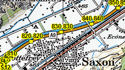
Points de repères sur les routes nationales
Système de repères de base des routes nationales permettant la localisation des activités et des événements. Chaque point de repère est signalé par une marque jaune à l'axe de la route et une plaquette d'identification de l'axe et du numéro du point de repère.
Simple
- Alternate title
-
Points de repères CH
- Date (Creation)
- 1990-01-01
- Date (Revision)
- 2024-09-19
- Identifier
- 370
- Purpose
-
Repérage des activités et des événements sur les routes cantonales
- Status
- On going
Custodian
- Spatial representation type
- Vector
Spatial resolution
Equivalent scale
- Denominator
- 10000
- Topic category
-
- P Transportation
Extent
Extent
- Description
-
Canton of Valais (VS)
))

- Maintenance and update frequency
- Annually
Resource format
- Title
-
ESRI Enterprise Geodatabase
- Date
- GEMET - INSPIRE themes, version 1.0
-
-
Transport networks
-
- GEMET
-
-
road maintenance
-
- geocat.ch
-
-
locating
-
opendata.swiss
-
Resource constraints
- Use limitation
-
Importation données OFROU (sans garantie de mise à jour)
Resource constraints
- Access constraints
- Other restrictions
- Other constraints
-
Géodonnées accessibles au public (niveau A selon l'OGéo)
- Other constraints
-
Les conditions générales d'utilisation des géodonnées du Canton du Valais font foi ( https://www.vs.ch/fr/web/guest/information-legale).
- Language
- Français
- Character encoding
- UTF8
- Language
- Deutsch
- Character encoding
- UTF8
- Environment description
-
S:\Géodonnées VS\P Transport\SRB.lyr
- Included with dataset
- 0
- Title
-
Structure - Point de repère CH
- Date (Creation)
- 2016-06-20
- Distribution format
-
-
ESRI Shapefile (SHP)
-
autres formats sur demande / andere Formate auf Anfrage
-
ArcGIS REST Feature Service
-
Distributor
Digital transfer options
- OnLine resource
-
OpenData Valais
OpenData Valais - Site de téléchargement de géodonnées à l'Etat du Valais : multiformat et WebMercator
Digital transfer options
- OnLine resource
-
Landing Page
Landing Page pour opendata
Digital transfer options
- OnLine resource
-
Géoportail du Canton du Valais
Géoportail du Canton du Valais
Digital transfer options
- OnLine resource
-
Permalink opendata.swiss
Permalink opendata.swiss
Digital transfer options
- OnLine resource
-
VS_M_RN
Routes Nationales
Digital transfer options
- OnLine resource
-
VS_M_RN/PR_intermediaire
Routes Nationales
Digital transfer options
- OnLine resource
-
VS_M_RN/PR_debut-fin
Routes Nationales
- Statement
-
Plans 1:10'000, croquis de relevé, longueur des secteurs sur la chaussée.
- Hierarchy level
- Dataset
- Description
-
Digitalisation ou conversion (DAO) + GNSS
- Geometric object type
- Point
- Geometric object count
- 982
- Reference system identifier
- EPSG:2056/CH1903+_MN95
Metadata
- Metadata identifier
- f19dda76-30b7-41f7-9e6b-743cb2b3f90d
- Language
- Français
- Character encoding
- UTF8
- Language
- Deutsch
- Character encoding
- UTF8
- Language
- Italiano
- Character encoding
- UTF8
- Language
- English
- Character encoding
- UTF8
- Language
- Rumantsch
- Character encoding
- UTF8
Distributor
Type of resource
- Resource scope
- Dataset
- Metadata linkage
-
https://www.geocat.ch/geonetwork/srv/api/records/f19dda76-30b7-41f7-9e6b-743cb2b3f90d
- Date info (Creation)
- 2017-05-23T09:48:40Z
- Date info (Revision)
- 2026-04-13T09:34:36.928704Z
Metadata standard
- Title
-
eCH-0271