geocat.ch
Hydrogeologische Karte der Schweiz: Grundwasservorkommen 1:500000
Carte hydrogéologique de la Suisse : Réservoirs aquifères 1:500000
Carta idrogeologica della Svizzera: riserve acquifere 1:500000
Hydrogeological Map of Switzerland: Groundwater Resources 1:500000
Charta idrogeologica da la Svizra: resursas d'aua sutterrana 1:500'000
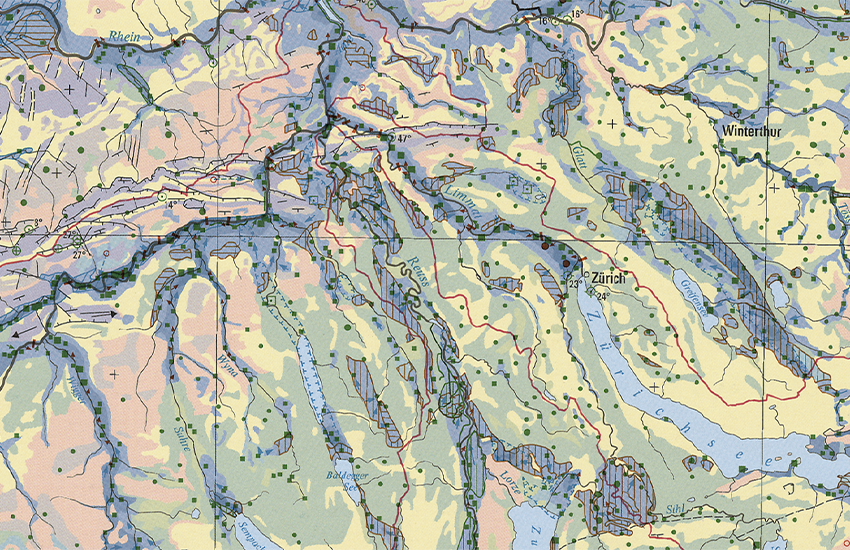
Das Bundesamt für Umwelt BAFU ist die zuständige Fachstelle der Landesgeologie für Hydrogeologie. Die Hydrogeologische Karte 1:500'000 ist in die Serie Geokarten (GK500) integriert und gliedert sich in zwei Blätter. Das erste (GK500-Hydro) stellt die verschiedenen Grundwasservorkommen der Schweiz und deren Ergiebigkeit, das zweite (GK500-Hydro_Vul) die Empfindlichkeit der Grundwasservorkommen bezüglich möglicher Gefährdungen durch Schadstoffe dar. Das Blatt Grundwasservorkommen zeigt zudem die Art der Grundwasserzirkulation (Karst-, Kluft- und Lockergesteine), die wichtigsten Quell- und Grundwasserfassungen sowie hydrodynamische Angaben zu den Infiltrations- und Exfiltrationsgebieten. Die beiden Blätter wurden ursprünglich als Tafeln 8.6 und 8.7 des Hydrologischen Atlas der Schweiz HADES (BAFU, 2004 und 2007) herausgegeben.
L’Office fédéral de l’environnement OFEV est l’office compétent du Service géologique national pour l'hydrogéologie. La Carte hydrogéologique 1:500'000 est dans la série GéoCartes (GK500) et composée de deux feuilles. La première (GK500-Hydro) est consacrée aux réservoirs aquifères et fournit des informations sur leur productivité. La seconde (GK500-Hydro_Vul) traite de la vulnérabilité de ces réservoirs et de leur sensibilité à des menaces possibles par des polluants. En outre la première feuille montre la nature des réservoirs aquifères (roches karstiques, meubles ou cohérentes), les principaux captages d'eau souterraine et d'eau de source et fournit des données hydrodynamiques sur les régions d'infiltration et d'exfiltration des eaux. Le contenu des deux feuilles est également publié comme Planche 8.6 et 8.7 de l'Atlas hydrologique de la Suisse HADES (OFEV, 2004 et 2007).
L'Ufficio federale dell'ambiente (UFAM) è il servizio competente per l’idrogeologia del Servizio geologico nazionale. La carta idrogeologica 1:500'000 è integrata nella serie Geocarte500 (GK500) ed è strutturata in due fogli. Il primo foglio (GK500-Hydro) è dedicato alle diverse falde acquifere della Svizzera e al loro rendimento, il secondo (GK500-Hydro_Vul) alla vulnerabilità delle falde acquifere con riferimento a potenziali pericoli da parte di agenti inquinanti. Il primo foglio mostra inoltre il tipo di circolazione delle falde acquifere (rocce carsiche, coerenti e incoerenti), i principali tipi di falde acquifere nonché informazioni idrodinamiche sulle zone di infiltrazione e di esfiltrazione. I due fogli sono stati pubblicati in origine sottoforma di tavole 8.6 e 8.7 dell'Atlante idrologico della Svizzera HADES (UFAM, 2004 e 2007).
The Federal Office for the Environment (FOEN) is the body within the Swiss Geological Survey responsible for hydrogeology. The 1:500,000 Hydrogeological Map forms part of the GeoMaps series (GK500) and is divided into two sheets. The first (GK500-Hydro) represents the various groundwater resources in Switzerland and their productiveness. The second (GK500-Hydro_Vul) shows the vulnerability of the groundwater resources to the risk of pollution. The groundwater resources sheet also indicates the type of groundwater aquifer (karstic, jointed or unconsolidated rock), the most important springs and groundwater catchments as well as hydrodynamic information about the infiltration and exfiltration areas. The two sheets were originally published as Tables 8.6 and 8.7 of the Hydrological Atlas of Switzerland HADES (FOEN, 2004 and 2007).
L'Uffizi federal d'ambient UFAM è il post spezialisà dal Servetsch geologic naziunal ch'è cumpetent per l'idrogeologia. La Charta idrogeologica 1:500'000 è integrada en la seria da las GeoChartas (GK500) e sa cumpona da dus fegls. L'emprim (GK500-Hydro) preschenta las differentas resursas d'aua sutterrana da la Svizra e lur productivitad, il segund (GK500-Hydro_Vul) la vulnerabilitad da las resursas d'aua sutterrana areguard eventualas periclitaziuns tras substanzas nuschaivlas. L'emprim fegl mussa ultra da quai il gener da las resursas d'aua sutterrana (crap carstic, crappa cun sfessas e crappa lucca), las tschiffadas las pli impurtantas da funtauna e d'aua sutterrana sco er indicaziuns idrodinamicas areguard ils territoris d'infiltraziun e d'exfiltraziun. Oriundamain èn ils dus fegls vegnids edids sco tavlas 8.6 ed 8.7 da l'Atlas idrologic da la Svizra HADES (UFAM, 2004 e 2007).
Simple
-
Autre titreAltri nomi o acronimiAlternate titleAlternate titleAlternativtitel
-
Grundwasservorkommen 500
Réservoirs aquifères 500
Falde acquifere 500
Groundwater Resources 500
Resursas d'aua sutterrana 500
-
Date (Publication)Data (Pubblicazione)Date (Publication)Date (Publication)Datum (Publikation)
- 2007-09-14
-
IdentifiantIdentificatoreIdentifierIdentifierKennung
- ch.swisstopo.geologie-hydrogeologische_karte-grundwasservorkommen
-
Forme de la présentationForma della presentazionePresentation formPresentation formPräsentationsform
-
Carte papierMappa cartaceaHardcopy mapHardcopy mapPapierkarte
-
Forme de la présentationForma della presentazionePresentation formPresentation formPräsentationsform
-
Carte numériqueMappa digitaleDigital mapDigital mapDigitale Karte
-
NomNomeNameNameName
-
GeoKarten 500
-
ÉtatStatoStatusStatusBearbeitungsstatus
-
TerminéCompletatoCompletedCompletedAbgeschlossen
Distributeur
Distributore
Distributor
Distributor
Verteiler
Point de contact
Punto di contatto
Point of contact
Point of contact
Ansprechpartner
Propriétaire
Proprietario
Owner
Owner
Eigentümer
-
Type de représentation spatialeTipo di rappresentazione spazialeSpatial representation typeSpatial representation typeRäumliche Darstellungsart
-
grilleRasterGridGridRaster, Gitter
-
Type de représentation spatialeTipo di rappresentazione spazialeSpatial representation typeSpatial representation typeRäumliche Darstellungsart
-
vecteurVettorialeVectorVectorVektor
-
Type de représentation spatialeTipo di rappresentazione spazialeSpatial representation typeSpatial representation typeRäumliche Darstellungsart
-
paperMappaperMappaperMappaperMappaperMap
Résolution spatiale
Risoluzione spaziale
Spatial resolution
Spatial resolution
Räumliche Auflösung
Fraction représentative
Frazione rappresentativa
Equivalent scale
Equivalent scale
Vergleichsmassstab
-
DénominateurDenominatoreDenominatorDenominatorMassstabszahl
- 500000
-
Catégorie de thèmeCategoria ISOTopic categoryTopic categoryThematik
-
-
F Informations géoscientifiquesF Informazioni geoscientificheF Geoscientific informationF Geoscientific informationF Erdwissenschaften
-
Étendue
Estensione
Extent
Extent
Ausdehnung
Étendue
Estensione
Extent
Extent
Ausdehnung
-
DescriptionDescrizioneDescriptionDescriptionBeschreibung
-
National Map 1:500'000
Landeskarte 1:500'000
Carte nationale 1:500'000
Carta nazionale 1:500'000
Landeskarte 1:500'000
-
Identifiant géographiqueIdentificatore geograficoGeographic identifierGeographic identifierGeografische Kennung
- NM500LK500CN500CN500LK500
))

-
Fréquence de mise à jourFrequenza di aggiornamentoMaintenance and update frequencyMaintenance and update frequencyWartungsintervall
-
Comme nécessaireSecondo necessitàAs neededAs neededBei Bedarf
-
Durée de conservationDurata di conservazioneDuration of ConservationDuration of ConservationAufbewahrungsdauer NV in Jahren
- 275
-
Évaluation de la valeur archivistiqueValutazione del valore archivisticoAppraisal of Archival ValueAppraisal of Archival ValueBewertung Archivwürdigkeit
-
AAAAA
-
Raison de la valeur d'archivageMotivo del valore archivisticoReason for Archiving ValueReason for Archiving ValueBegründung Archivwürdigkeit
-
Preuve de la pratique couranteProva della pratica commercialeEvidence of business practiceEvidence of business practiceNachweis der Geschäftspraxis
- geocat.ch
-
-
Planification de la conservation et de l'archivage AAP - Conféderation
Pianificazione della conservazione e dell’archiviazione AAP - Confederazione
Conservation and archiving planning AAP - Confederation
-
géodonnées de base
geodati di base
official geodata
-
opendata.swiss
opendata.swiss
opendata.swiss
opendata.swiss
-
e-geo.ch
e-geo.ch
e-geo.ch
-
- GEMET
-
-
eaux souterraines
acqua sotterranea
groundwater
-
sciences de la terre
scienze della terra
earth science
-
aquifère
acquifero
aquifer
-
hydrogéologie
idrogeologia
hydrogeology
-
- GEMET - INSPIRE themes, version 1.0
-
-
Géologie
Geologia
Geology
-
- geocat.ch
-
-
BGDI Bundesgeodaten-Infrastruktur
IFDG l’Infrastructure Fédérale de données géographiques
IFDG Infrastruttura federale dei dati geografici
FSDI Federal Spatial Data Infrastructure
-
Ressource associée
Risorsa associata
Associated resource
Associated resource
Verlinkte Ressource
-
TitreTitoloTitleTitleTitel
-
Geologisches Kartenwerk
Cartes géologiques
Carte geologiche
Geological maps
-
Type d'associationTipo di associazioneAssociation TypeAssociation TypeAssoziationstyp
-
Citation de travail plus largeCitazione di un'opera più ampiaReference to a master resource of which this one is a partReference to a master resource of which this one is a partÜbergeordneter Datenbestand
-
LangueLinguaLanguageLanguageSprache
- Deutsch
-
Encodage de caractèresCodifica dei caratteriCharacter encodingCharacter encodingZeichenkodierung
-
Utf8UTF8UTF8UTF8Utf8
-
LangueLinguaLanguageLanguageSprache
- Français
-
Encodage de caractèresCodifica dei caratteriCharacter encodingCharacter encodingZeichenkodierung
-
Utf8UTF8UTF8UTF8Utf8
-
Informations supplémentairesInformazioni supplementariSupplemental InformationSupplemental InformationZusätzliche Informationen
-
Diese Karte ist als Druckversion (gefalzt oder plano), Pixelkarte oder Vektordatensatz erhältlich.
Cette carte est disponibles en version imprimée (plié ou plano), carte-pixel et jeux de données vectorielles.
-
Catégorie de sous-thèmeCategoria di sottotemaSubtopic CategorySubtopic CategoryThematische Unterkategorien
-
F1 GéologieF1 GeologiaF1 GeologyF1 GeologyF1 Geologie
-
Géodonnées de baseGeodati di baseBasic GeodataBasic GeodataGeobasisdaten
- true
-
Identifiant Géodonnées de baseIdentificativo dei geodati di baseBasic Geodata IDBasic Geodata IDIdentifikator des Geobasisdatensatzes
-
46.6
-
Niveau des géodonnées de baseLivello legale dei geodati di baseBasic Geodata Legal LevelBasic Geodata Legal LevelGeobasisdatenebene
-
FédéralFederaleFederalFederalNational
-
Format de distributionFormato (codifica)Distribution formatDistribution formatAbgabeformat
-
-
analog
-
GeoTIFF (GEOTIFF)
-
ESRI Shapefile (SHP)
-
Options de transfert numérique
Opzioni di trasferimento digitale
Digital transfer options
Digital transfer options
Optionen für die digitale Übertragung
-
Ressource en ligneRisorsa onlineOnLine resourceOnLine resourceOnline
-
Vorschau map.geo.admin.ch
Vorschau map.geo.admin.chAperçu map.geo.admin.chPrevisione map.geo.admin.chPreview map.geo.admin.ch
Options de transfert numérique
Opzioni di trasferimento digitale
Digital transfer options
Digital transfer options
Optionen für die digitale Übertragung
-
Ressource en ligneRisorsa onlineOnLine resourceOnLine resourceOnline
-
ch.swisstopo.geologie-hydrogeologische_karte-grundwasservorkommen
WMS-BGDI Dienst, Layer "Grundwasservorkommen 500"Service WMS-IFDG, couche "Réservoirs aquifères 500"Servizio WMS-IFDG, strato "Falde acquifere 500"WMS-FSDI service, layer "Groundwater Resources 500"WMS-BGDI Dienst, Layer "Grundwasservorkommen 500"
Options de transfert numérique
Opzioni di trasferimento digitale
Digital transfer options
Digital transfer options
Optionen für die digitale Übertragung
-
Ressource en ligneRisorsa onlineOnLine resourceOnLine resourceOnline
-
ch.swisstopo.geologie-hydrogeologische_karte-grundwasservorkommen
WMTS-BGDI Dienst, Layer "Grundwasservorkommen 500"Service WMTS-IFDG, couche , Layer "Réservoirs aquifères 500"Servizio WMTS-IFDG, strato "Falde acquifere 500"WMTS-FSDI service, layer "Groundwater Resources 500"WMTS-BGDI Dienst, Layer "Grundwasservorkommen 500"
Options de transfert numérique
Opzioni di trasferimento digitale
Digital transfer options
Digital transfer options
Optionen für die digitale Übertragung
Options de transfert numérique
Opzioni di trasferimento digitale
Digital transfer options
Digital transfer options
Optionen für die digitale Übertragung
Options de transfert numérique
Opzioni di trasferimento digitale
Digital transfer options
Digital transfer options
Optionen für die digitale Übertragung
Options de transfert numérique
Opzioni di trasferimento digitale
Digital transfer options
Digital transfer options
Optionen für die digitale Übertragung
Options de transfert numérique
Opzioni di trasferimento digitale
Digital transfer options
Digital transfer options
Optionen für die digitale Übertragung
Options de transfert numérique
Opzioni di trasferimento digitale
Digital transfer options
Digital transfer options
Optionen für die digitale Übertragung
-
Ressource en ligneRisorsa onlineOnLine resourceOnLine resourceOnline
-
RESTful API von geo.admin.ch
RESTful API von geo.admin.chRESTful API de geo.admin.chRESTful API da geo.admin.chRESTful API from geo.admin.chRESTful API dad geo.admin.ch
-
Nom du système de référenceNome del sistema di riferimentoReference system identifierReference system identifierName des Referenzsystems
- Referenzsystem entsprechend der zugrundeliegenden topographischen Karte (CH1903)
Metadata
-
Identifiant des métadonnéesIdentificativo della schedaMetadata identifierMetadata identifierIdentifikator des Metadatensatzes
- f198f6f6-8efa-4235-a55f-99767ea0206c
-
LangueLinguaLanguageLanguageSprache
- Deutsch
-
Encodage de caractèresCodifica dei caratteriCharacter encodingCharacter encodingZeichenkodierung
-
Utf8UTF8UTF8UTF8Utf8
-
LangueLinguaLanguageLanguageSprache
- Français
-
Encodage de caractèresCodifica dei caratteriCharacter encodingCharacter encodingZeichenkodierung
-
Utf8UTF8UTF8UTF8Utf8
-
LangueLinguaLanguageLanguageSprache
- Italiano
-
Encodage de caractèresCodifica dei caratteriCharacter encodingCharacter encodingZeichenkodierung
-
Utf8UTF8UTF8UTF8Utf8
-
LangueLinguaLanguageLanguageSprache
- English
-
Encodage de caractèresCodifica dei caratteriCharacter encodingCharacter encodingZeichenkodierung
-
Utf8UTF8UTF8UTF8Utf8
-
LangueLinguaLanguageLanguageSprache
- Rumantsch
-
Encodage de caractèresCodifica dei caratteriCharacter encodingCharacter encodingZeichenkodierung
-
Utf8UTF8UTF8UTF8Utf8
Point de contact
Punto di contatto
Point of contact
Point of contact
Ansprechpartner
Type de ressource
Tipo di risorsa
Type of resource
Type of resource
Anwendungsbereich der Metadaten
-
Domaine d'application de la ressourceAmbito di applicazione della risorsaResource scopeResource scopeDomäne der Ressourcenanwendung
-
Jeu de donnéesSet di datiDatasetDatasetDatenbestand
-
Lien vers la métadonnéeCollegamento ai metadatiMetadata linkageMetadata linkageLink zu den Metadaten
-
Informations de date (Création)Informazioni sulla data (Creazione)Date info (Creation)Date info (Creation)Datumsangaben (Erstellung)
- 2009-06-11T12:00:00Z
-
Informations de date (Révision)Informazioni sulla data (Revisione)Date info (Revision)Date info (Revision)Datumsangaben (Aktualisierung)
- 2026-04-13T09:46:17.007409Z
Norme des métadonnées
Standard dei metadati
Metadata standard
Metadata standard
Metadatenstandard
-
TitreTitoloTitleTitleTitel
-
eCH-0271