 geocat.ch
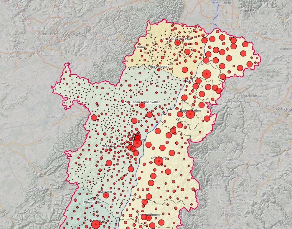
Centroïdes et population des communes du Rhin Supérieur
Oberrheingebiet Zentren und Bevölkerung der Gemeinden
Upper Rhine Centroids and population of communes
Centroïdes (2019) et population (2016) des communes du Rhin Supérieur
Oberrheingebiet Zentren (2019) und Bevölkerung (2016) der Gemeinden
Upper Rhine Centroids (2019) and population of communes (2016)
Simple
-
AlternativtitelAlternate titleAutre titre
-
Centroïdes et population - 2019
Zentren und Bevölkerung - 2019
Centroids and population of communes - 2019
-
Datum (Erstellung)Date (Creation)Date (Création)
- 2019-01-01
-
Datum (Publikation)Date (Publication)Date (Publication)
- 2019-01-01
-
KennungIdentifierIdentifiant
- CentresCommunes_GemeindenZentren_2019
-
BearbeitungsstatusStatusÉtat
-
ErforderlichRequiredRequis
Kontakt für die Ressource
Point of contact
Contact pour la ressource
-
mri:deliveryPointmri:deliveryPointmri:deliveryPoint
-
100, avenue d'Alsace
100, avenue d'Alsace
-
mri:citymri:citymri:city
-
COLMAR
-
mri:postalCodemri:postalCodemri:postalCode
-
68000
-
mri:countryCountrymri:country
-
FRANCE
FRANCE
-
Räumliche DarstellungsartSpatial representation typeType de représentation spatiale
-
VektorVectorvecteur
Räumliche Auflösung
Spatial resolution
Résolution spatiale
Vergleichsmassstab
Equivalent scale
Fraction représentative
-
MassstabszahlDenominatorDénominateur
- 50000
-
ThematikTopic categoryCatégorie de thème
-
-
D GrenzenD BoundariesD Limites
-
Ausdehnung
Extent
Étendue
Ausdehnung
Extent
Étendue
Zeitlicher Umfang
Temporal extent
Étendue temporelle
-
ZeitraumTime periodPériode
- 2020-01-01 2020-12-31
Ausdehnung
Extent
Étendue
Ausdehnung
Extent
Étendue
))
-
WartungsintervallMaintenance and update frequencyFréquence de mise à jour
-
JährlichAnnuallyAnnuelle
- Keywords
-
-
Données ouvertes
Open-Data
Open-Data
-
-
OrtPlacePosition
-
-
Rhin Supérieur
Oberrhein
Upper Rhine
-
- GEMET - INSPIRE themes, version 1.0
-
-
Unités statistiques
Statistische Einheiten
Statistical units
-
Dénominations géographiques
Geografische Bezeichnungen
Geographical names
-
Unités administratives
Verwaltungseinheiten
Administrative units
-
- GEMET - Concepts, version 2.4
-
-
limite administrative
Verwaltungsgrenze
administrative boundary
-
commune
Gemeinde
municipality
-
données statistiques
Statistische Daten
statistical data
-
démographie
Demographie
demography
-
Ressourcenbeschränkungen
Resource constraints
Contraintes sur la ressource
-
NutzungsbeschränkungUse limitationLimitation d'utilisation
-
Ajoutez logo GeoRhena en cas de réutilisation + © OpenStreetMap contributors + INSEE 2016 + OFS 2016 + STALA BW 2016 + STALA RP 2016
Das GeoRhena Logo verwenden für alle benutzung GeoRhena 2016 + © OpenStreetMap contributors + INSEE 2016 + OFS 2016 + STALA BW 2016 + STALA RP 2016
© + OSM contributors + Add GeoRhena logo in case of reuse + INSEE 2016 + OFS 2016 + STALA BW 2016 + STALA RP 2016
-
SpracheLanguageLangue
- English
-
ZeichenkodierungCharacter encodingEncodage de caractères
-
Utf8UTF8Utf8
-
AbgabeformatDistribution formatFormat de distribution
-
-
Géodonnée au format SHP
GeoDatei im SHP Format
SHP GeoData
-
Optionen für die digitale Übertragung
Digital transfer options
Options de transfert numérique
-
OnlineOnLine resourceRessource en ligne
-
centroides_communes
Centroïdes des communes du Rhin SupérieurZentren der Gemeinden im Oberrheingebiet
Optionen für die digitale Übertragung
Digital transfer options
Options de transfert numérique
-
OnlineOnLine resourceRessource en ligne
-
boundaries:centroides_communes
Centroïdes des communes du Rhin SupérieurZentren der Gemeinden im Oberrheingebiet
Optionen für die digitale Übertragung
Digital transfer options
Options de transfert numérique
-
OnlineOnLine resourceRessource en ligne
-
Téléchargement du Shapefile
Téléchargement du Shapefile
Téléchargement du Shapefile
-
ErklärungStatementGénéralités sur la provenance
-
GeoRhena + OSM contributors - 2019
GeoRhena + OSM contributors - 2019
GeoRhena + OSM contributors - 2019
-
BezugsebeneHierarchy levelNiveau
-
DatenbestandDatasetJeu de données
Metadata
-
Identifikator des MetadatensatzesMetadata identifierIdentifiant des métadonnées
- f16935e8-2ffe-4103-a1ce-114b0aabab18
-
SpracheLanguageLangue
- Français
-
ZeichenkodierungCharacter encodingEncodage de caractères
-
Utf8UTF8Utf8
-
SpracheLanguageLangue
- Deutsch
-
ZeichenkodierungCharacter encodingEncodage de caractères
-
Utf8UTF8Utf8
-
SpracheLanguageLangue
- English
-
ZeichenkodierungCharacter encodingEncodage de caractères
-
Utf8UTF8Utf8
Kontaktstelle für Metadaten
Contact
Point de contact des métadonnées
Anwendungsbereich der Metadaten
Type of resource
Type de ressource
-
Domäne der RessourcenanwendungResource scopeDomaine d'application de la ressource
-
DatenbestandDatasetJeu de données
-
Datumsangaben (Aktualisierung)Date info (Revision)Informations de date (Révision)
- 2025-01-28T08:16:47.970032Z
Metadatenstandard
Metadata standard
Norme des métadonnées
-
TitelTitleTitre
-
ISO 19115-3:2018
-
AusgabeEditionÉdition
-
1.0
)))