 geocat.ch
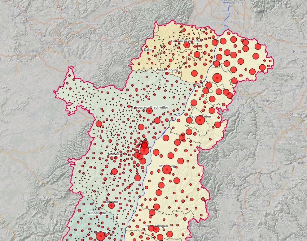
Upper Rhine Centroids and population of communes
Upper Rhine Centroids (2019) and population of communes (2016)
Simple
- Alternate title
-
Centroids and population of communes - 2019
- Date (Creation)
- 2019-01-01
- Date (Publication)
- 2019-01-01
- Identifier
- CentresCommunes_GemeindenZentren_2019
- Status
- Required
Point of contact
- mri:deliveryPoint
-
100, avenue d'Alsace
- mri:city
-
COLMAR
- mri:postalCode
-
68000
- Country
-
FRANCE
- Spatial representation type
- Vector
Spatial resolution
Equivalent scale
- Denominator
- 50000
- Topic category
-
- D Boundaries
Extent
Extent
Temporal extent
- Time period
- 2020-01-01 2020-12-31
Extent
Extent
N
S
E
W
))
- Maintenance and update frequency
- Annually
- Keywords
-
-
Open-Data
-
- Place
-
-
Upper Rhine
-
- GEMET - INSPIRE themes, version 1.0
-
-
Statistical units
-
Geographical names
-
Administrative units
-
- GEMET - Concepts, version 2.4
-
-
administrative boundary
-
municipality
-
statistical data
-
demography
-
Resource constraints
- Use limitation
-
© + OSM contributors + Add GeoRhena logo in case of reuse + INSEE 2016 + OFS 2016 + STALA BW 2016 + STALA RP 2016
- Language
- English
- Character encoding
- UTF8
- Distribution format
-
-
SHP GeoData
-
Digital transfer options
- OnLine resource
-
centroides_communes
Centroïdes des communes du Rhin Supérieur
Digital transfer options
- OnLine resource
-
boundaries:centroides_communes
Centroïdes des communes du Rhin Supérieur
Digital transfer options
- OnLine resource
-
Téléchargement du Shapefile Téléchargement du Shapefile
- Statement
-
GeoRhena + OSM contributors - 2019
- Hierarchy level
- Dataset
Metadata
- Metadata identifier
- f16935e8-2ffe-4103-a1ce-114b0aabab18
- Language
- Français
- Character encoding
- UTF8
- Language
- Deutsch
- Character encoding
- UTF8
- Language
- English
- Character encoding
- UTF8
Contact
- mdb:deliveryPoint
-
100, avenue d'Alsace
- mdb:city
-
COLMAR
- mdb:postalCode
-
68000
- mdb:country
-
FR
Type of resource
- Resource scope
- Dataset
- Date info (Revision)
- 2025-01-28T08:16:47.970032Z
Metadata standard
- Title
-
ISO 19115-3:2018
- Edition
-
1.0
)))