geocat.ch
Switzerland During the Last Glacial Maximum (LGM) 1:500000
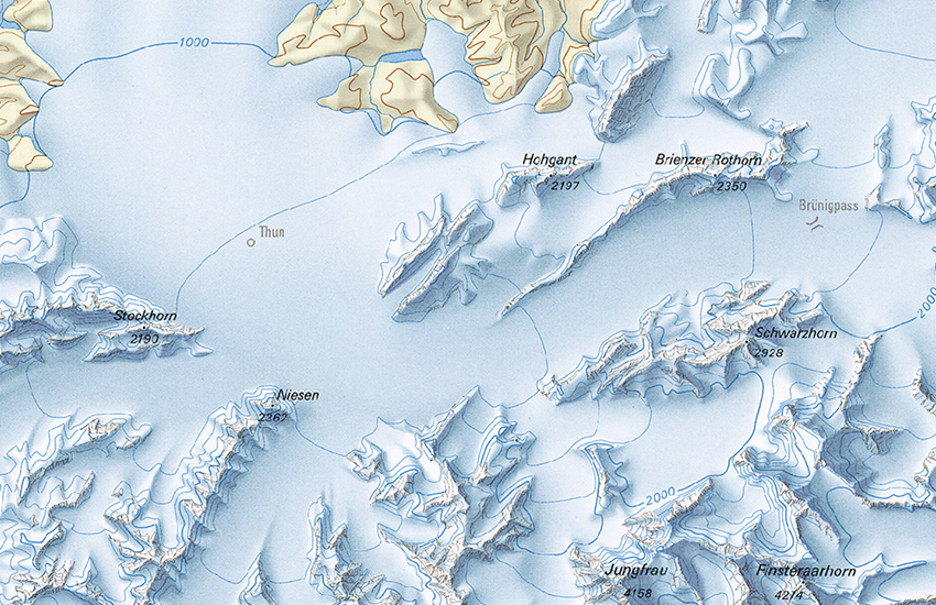
The map (GK500-LGM) shows the maximum extent of glaciation in Switzerland at the height of the last Ice Age around 24,000 years ago. It presents the latest results of current research on the Ice Age in the form of a high-quality map. The build-up and retreat of glaciers are indications of significant climate-related environmental changes during the relatively recent history of the Earth. - By "Schlüchter, C. (compil.) 2009. Die Schweiz während des letzteiszeitlichen Maximums (LGM), 1:500’000. GeoKarten500, Bundesamt für Landestopografie swisstopo, Wabern."
Simple
- Alternate title
-
Last glacial maximum (map) 500
- Date (Publication)
- 2009-12-31
- Identifier
- ch.swisstopo.geologie-eiszeit-lgm-raster
- Presentation form
- Hardcopy map
- Presentation form
- Digital map
- Name
-
GeoKarten 500
- ISBN
-
978-3-302-40049-5
- Purpose
-
Darstellung der grössten Gletscherausdehnung in der Schweiz während des Höhepunkts der letzten Eiszeit
- Status
- Completed
Distributor
Point of contact
- Spatial representation type
- Grid
- Spatial representation type
- paperMap
Spatial resolution
Equivalent scale
- Denominator
- 500000
- Topic category
-
- F Geoscientific information
Extent
Extent
- Description
-
Last Glacial Maximum
- Geographic identifier
- LGM
))

- Maintenance and update frequency
- Not planned
- GEMET
-
-
glaciology
-
- geocat.ch
-
-
opendata.swiss
-
e-geo.ch
-
glaciation
-
- geocat.ch
-
-
FSDI Federal Spatial Data Infrastructure
-
Associated resource
- Title
-
Geological maps
- Association Type
- Reference to a master resource of which this one is a part
- Language
- Deutsch
- Character encoding
- UTF8
- Language
- Français
- Character encoding
- UTF8
- Language
- Italiano
- Character encoding
- UTF8
- Language
- English
- Character encoding
- UTF8
- Subtopic Category
- F1 Geology
- Basic Geodata
- true
- Basic Geodata ID
-
46.8
- Basic Geodata Legal Level
- Federal
- Distribution format
-
-
analog
-
GeoTIFF (GEOTIFF)
-
Digital transfer options
- OnLine resource
-
Vorschau map.geo.admin.ch
Preview map.geo.admin.ch
Digital transfer options
- OnLine resource
-
ch.swisstopo.geologie-eiszeit-lgm-raster
WMS-FSDI service, layer "Last glacial maximum (map) 500"
Digital transfer options
- OnLine resource
-
ch.swisstopo.geologie-eiszeit-lgm-raster
WMTS-FSDI service, layer "Last glacial maximum (map) 500"
Digital transfer options
- OnLine resource
-
Produkte- und Bestellinformationen
Digital transfer options
- OnLine resource
-
Download (data.geo.admin.ch)
Digital transfer options
- OnLine resource
-
Thema Geologie (map.geologieportal.ch)
Digital transfer options
- OnLine resource
-
swisstopo: Daten der Landesgeologie
Digital transfer options
- OnLine resource
-
Geologie-Portal: Quartärgeologie
- Reference system identifier
- Referenzsystem entsprechend der zugrundeliegenden topographischen Karte (CH1903)
Metadata
- Metadata identifier
- f1455593-7571-48b0-8603-307ec59a6702
- Language
- Deutsch
- Character encoding
- UTF8
- Language
- Français
- Character encoding
- UTF8
- Language
- Italiano
- Character encoding
- UTF8
- Language
- English
- Character encoding
- UTF8
- Language
- Rumantsch
- Character encoding
- UTF8
Point of contact
Type of resource
- Resource scope
- Dataset
- Metadata linkage
-
https://www.geocat.ch/geonetwork/srv/api/records/f1455593-7571-48b0-8603-307ec59a6702
- Date info (Creation)
- 2010-07-14T09:21:07Z
- Date info (Revision)
- 2026-04-13T09:25:46.532948Z
Metadata standard
- Title
-
eCH-0271