geocat.ch
Arealstatistik der Schweiz
Statistique de la superficie de la Suisse
Statistica della superficie per la Svizzera
Swiss land use statistics
Die Arealstatistik liefert detaillierte und genaue Informationen über den Zustand und die Entwicklung der Bodennutzung und Bodenbedeckung in der Schweiz. Auf dieser Seite finden Sie die Geodaten der Arealstatistik in Hektarauflösung seit 1979, sowie Informationen über die Grundlagen und Methode zur Erstellung dieser Daten.
La statistique de la superficie fournit des informations détaillées et précises sur l’état et l’évolution de l’utilisation et de la couverture du sol en Suisse. Vous trouverez sur cette page les géodonnées de la statistique de la superficie à l’échelle de l’hectare depuis 1979, ainsi que des informations sur les bases et la méthode de production de ces données.
The Swiss Land Use Statistic provides detailed and accurate information on the state and evolution of land use and land cover in Switzerland. On this page you will find the geodata of the Land Use Statistics at the hectare level since 1979, as well as documentation on the data and the methodology used to produce these data.
Simple
-
Autre titreAltri nomi o acronimiAlternate titleAlternate titleAlternativtitel
-
Arealstatistik
Statistique de la superficie
Statistica della superficie
Land use statistics
Statistica d'areals
-
Date (Révision)Data (Revisione)Date (Revision)Date (Revision)Datum (Aktualisierung)
- 2023-08-30
-
IdentifiantIdentificatoreIdentifierIdentifierKennung
- ch.bfs.arealstatistik
-
ButScopoPurposePurposeZweck
-
Detaillierte Erhebung der Bodennutzung und -bedeckung der Schweiz mit dem Ziel, deren Zustand und Entwicklung periodisch auszuweisen.
Relevé détaillé de l'utilisation et de la couverture du sol afin de documenter périodiquement l'état et l'évolution du paysage en Suisse
-
ÉtatStatoStatusStatusBearbeitungsstatus
-
ContinuIn corsoOn goingOn goingKontinuierliche Aktualisierung
Point de contact
Punto di contatto
Point of contact
Point of contact
Ansprechpartner
Résolution spatiale
Risoluzione spaziale
Spatial resolution
Spatial resolution
Räumliche Auflösung
-
Distance de résolutionDistanza di risoluzioneSpatial resolutionSpatial resolutionDistanz
- 100 m
-
Catégorie de thèmeCategoria ISOTopic categoryTopic categoryThematik
-
-
A Imagerie, cartes de base et occupation du solA Mappe di base con immagini della copertura terrestreA Imagery base maps earth coverA Imagery base maps earth coverA Oberflächenbeschreibung
-
Étendue
Estensione
Extent
Extent
Ausdehnung
Étendue
Estensione
Extent
Extent
Ausdehnung
-
DescriptionDescrizioneDescriptionDescriptionBeschreibung
-
Switzerland
Schweiz
Suisse
Svizzera
Svizra
))

-
Fréquence de mise à jourFrequenza di aggiornamentoMaintenance and update frequencyMaintenance and update frequencyWartungsintervall
-
Comme nécessaireSecondo necessitàAs neededAs neededBei Bedarf
- GEMET - INSPIRE themes, version 1.0
-
-
Usage des sols
Utilizzo del territorio
Land use
-
Occupation des terres
Copertura del suolo
Land cover
-
- GEMET
-
-
végétation
vegetazione
vegetation
-
- geocat.ch
-
-
BGDI Bundesgeodaten-Infrastruktur
IFDG l’Infrastructure Fédérale de données géographiques
IFDG Infrastruttura federale dei dati geografici
FSDI Federal Spatial Data Infrastructure
-
opendata.swiss
opendata.swiss
opendata.swiss
opendata.swiss
opendata.swiss
-
- GEMET
-
-
Luftbild
photographie aérienne
fotografia aerea (immagine)
aerial photograph
-
- geocat.ch
-
-
opendata.swiss
opendata.swiss
opendata.swiss
opendata.swiss
-
Contraintes sur la ressource
Vincoli sulle risorse
Resource constraints
Resource constraints
Ressourcenbeschränkungen
-
Limitation d'utilisationLimitazione d'usoUse limitationUse limitationNutzungsbeschränkung
-
Freie Nutzung. Quellenangabe ist Pflicht.
payant (abonnement aux géodonnées)
-
Contraintes d'accèsVincoli di accessoAccess constraintsAccess constraintsZugriffsbeschränkungen
-
Droits de propriété intellectuelleDiritti di proprietà intellettualeIntellectual property rightsIntellectual property rightsGeistiges Eigentum
-
Contraintes d'utilisationVincoli d'usoUse constraintsUse constraintsNutzungseinschränkungen
-
Autres restrictionsAltre restrizioniOther restrictionsOther restrictionsAndere Beschränkungen
-
Autres contraintesAltri vincoliOther constraintsOther constraintsAndere Einschränkungen
- Opendata BY ASK: Freie Nutzung. Quellenangabe ist Pflicht. Kommerzielle Nutzung nur mit Bewilligung des Datenlieferanten zulässig.Opendata BY ASK: Utilisation libre. Obligation d’indiquer la source. Utilisation commerciale uniquement avec l’autorisation du fournisseur des données.Opendata BY ASK: Libero utilizzo. Indicazione della fonte obbligatoria. Utilizzo a fini commerciali ammesso soltanto previo consenso del titolare dei dati.Opendata BY ASK: Open use. Must provide the source. Use for commercial purposes requires permission of the data owner.
Ressource associée
Risorsa associata
Associated resource
Associated resource
Verlinkte Ressource
-
Type d'associationTipo di associazioneAssociation TypeAssociation TypeAssoziationstyp
-
Citation de travail plus largeCitazione di un'opera più ampiaReference to a master resource of which this one is a partReference to a master resource of which this one is a partÜbergeordneter Datenbestand
-
Metadata ReferenceRiferimento metadatiMetadata ReferenceMetadata ReferenceMetadatenreferenz
Ressource associée
Risorsa associata
Associated resource
Associated resource
Verlinkte Ressource
-
TitreTitoloTitleTitleTitel
-
Arealstatistik der Schweiz
Statistique de la superficie de la Suisse
Statistica della superficie della Svizzera
-
Type d'associationTipo di associazioneAssociation TypeAssociation TypeAssoziationstyp
-
Citation de travail plus largeCitazione di un'opera più ampiaReference to a master resource of which this one is a partReference to a master resource of which this one is a partÜbergeordneter Datenbestand
-
LangueLinguaLanguageLanguageSprache
- Deutsch
-
Encodage de caractèresCodifica dei caratteriCharacter encodingCharacter encodingZeichenkodierung
-
Utf8UTF8UTF8UTF8Utf8
-
LangueLinguaLanguageLanguageSprache
- Français
-
Encodage de caractèresCodifica dei caratteriCharacter encodingCharacter encodingZeichenkodierung
-
Utf8UTF8UTF8UTF8Utf8
-
LangueLinguaLanguageLanguageSprache
- Italiano
-
Encodage de caractèresCodifica dei caratteriCharacter encodingCharacter encodingZeichenkodierung
-
Utf8UTF8UTF8UTF8Utf8
-
LangueLinguaLanguageLanguageSprache
- English
-
Encodage de caractèresCodifica dei caratteriCharacter encodingCharacter encodingZeichenkodierung
-
Utf8UTF8UTF8UTF8Utf8
-
Informations supplémentairesInformazioni supplementariSupplemental InformationSupplemental InformationZusätzliche Informationen
-
Originalresultate aller neueren Arealstatistiken werden bei GEOSTAT in relationalen Datenbanken verwaltet, in welchen jeder Stichprobenpunkt (die für jeden Erhebungszeitpunkt identisch sind) einen Datenrecord darstellt. Für die Diffusion können daraus gleichermassen strukturierte Textdateien (Normalfall), bei Bedarf aber auch GIS-kompatible Vektor- (Punktdaten) oder Rasterdaten (GRID, GeoTIFF) erzeugt werden.
Les résultats originaux de toutes les nouvelles statistiques de la superficie sont gérés par GEOSTAT dans des banques de données relationnelles. A chaque point d'échantillonnage correspond un enregistrement (les points d'échantillonnage sont identiques pour chaque relevé). Les résultats sont diffusés sous la forme de fichiers texte structurés (cas normal) ou, au besoin, sous la forme de données vectorielles (points) ou des données raster (GRID, GeoTIFF) compatibles SIG.
-
Catégorie de sous-thèmeCategoria di sottotemaSubtopic CategorySubtopic CategoryThematische Unterkategorien
-
A1 Cartes de base, modèles de paysageA1 Mappe di base, modelli paesaggisticiA1 Base Maps, Landscape ModelsA1 Base Maps, Landscape ModelsA1 Basiskarten, Landschaftsmodelle
-
Catégorie de sous-thèmeCategoria di sottotemaSubtopic CategorySubtopic CategoryThematische Unterkategorien
-
A2 Couverture du sol, utilisation du solA2 Copertura del suolo, uso del suoloA2 Land Cover, Land UseA2 Land Cover, Land UseA2 Bodenbedeckung, Bodennutzung
-
Géodonnées de baseGeodati di baseBasic GeodataBasic GeodataGeobasisdaten
- true
-
Identifiant Géodonnées de baseIdentificativo dei geodati di baseBasic Geodata IDBasic Geodata IDIdentifikator des Geobasisdatensatzes
-
12.3
-
Niveau des géodonnées de baseLivello legale dei geodati di baseBasic Geodata Legal LevelBasic Geodata Legal LevelGeobasisdatenebene
-
FédéralFederaleFederalFederalNational
-
Format de distributionFormato (codifica)Distribution formatDistribution formatAbgabeformat
-
-
TEXT, semicolon separated (CSV)
-
Options de transfert numérique
Opzioni di trasferimento digitale
Digital transfer options
Digital transfer options
Optionen für die digitale Übertragung
-
Ressource en ligneRisorsa onlineOnLine resourceOnLine resourceOnline
-
Vorschau map.geo.admin.ch
Options de transfert numérique
Opzioni di trasferimento digitale
Digital transfer options
Digital transfer options
Optionen für die digitale Übertragung
-
Ressource en ligneRisorsa onlineOnLine resourceOnLine resourceOnline
-
Geodaten (csv)
Options de transfert numérique
Opzioni di trasferimento digitale
Digital transfer options
Digital transfer options
Optionen für die digitale Übertragung
-
Ressource en ligneRisorsa onlineOnLine resourceOnLine resourceOnline
-
Variablenliste
Options de transfert numérique
Opzioni di trasferimento digitale
Digital transfer options
Digital transfer options
Optionen für die digitale Übertragung
-
Ressource en ligneRisorsa onlineOnLine resourceOnLine resourceOnline
-
ch.bfs.arealstatistik-bodenbedeckung
WMS-BGDI Dienst, Layer "Arealstatistik Bedeckung"Service WMS-IFDG, couche "Statistique de la superficie couverture"Servizio WMS-IFDG, strato "Statistica della superficie copertura"WMS-FSDI service, layer "Land use statistics cover"WMS-BGDI Dienst, Layer "Arealstatistik Bedeckung"
Options de transfert numérique
Opzioni di trasferimento digitale
Digital transfer options
Digital transfer options
Optionen für die digitale Übertragung
-
Ressource en ligneRisorsa onlineOnLine resourceOnLine resourceOnline
-
ch.bfs.arealstatistik-bodenbedeckung
WMTS-BGDI Dienst, Layer "Arealstatistik Bedeckung"Service WMTS-IFDG, couche , Layer "Statistique de la superficie couverture"Servizio WMTS-IFDG, strato "Statistica della superficie copertura"WMTS-FSDI service, layer "Land use statistics cover"WMTS-BGDI Dienst, Layer "Arealstatistik Bedeckung"
Options de transfert numérique
Opzioni di trasferimento digitale
Digital transfer options
Digital transfer options
Optionen für die digitale Übertragung
-
Ressource en ligneRisorsa onlineOnLine resourceOnLine resourceOnline
-
Geodata (csv)
Options de transfert numérique
Opzioni di trasferimento digitale
Digital transfer options
Digital transfer options
Optionen für die digitale Übertragung
-
Ressource en ligneRisorsa onlineOnLine resourceOnLine resourceOnline
-
Permalink opendata.swiss
Options de transfert numérique
Opzioni di trasferimento digitale
Digital transfer options
Digital transfer options
Optionen für die digitale Übertragung
-
Ressource en ligneRisorsa onlineOnLine resourceOnLine resourceOnline
-
Datenbeschreibung
Options de transfert numérique
Opzioni di trasferimento digitale
Digital transfer options
Digital transfer options
Optionen für die digitale Übertragung
-
Ressource en ligneRisorsa onlineOnLine resourceOnLine resourceOnline
-
GEOSTAT
GEOSTAT ist das BFS-Kompetenzzentrum für Geoinformation und digitale Bildverarbeitung.GEOSTAT est le centre de compétence pour la géoinformation et le traitement numérique des images digitales de l'OFS.GEOSTAT est le centre de compétence pour la géoinformation et le traitement numérique des images digitales de l'OFS.GEOSTAT is the centre of competence for geoinformation and digital image processing within the Swiss Federal Statistical Office.
Options de transfert numérique
Opzioni di trasferimento digitale
Digital transfer options
Digital transfer options
Optionen für die digitale Übertragung
-
Ressource en ligneRisorsa onlineOnLine resourceOnLine resourceOnline
-
Fachportal: Bodennutzung, -bedeckung
Options de transfert numérique
Opzioni di trasferimento digitale
Digital transfer options
Digital transfer options
Optionen für die digitale Übertragung
-
Ressource en ligneRisorsa onlineOnLine resourceOnLine resourceOnline
-
RESTful API von geo.admin.ch
RESTful API von geo.admin.chRESTful API de geo.admin.chRESTful API da geo.admin.chRESTful API from geo.admin.chRESTful API dad geo.admin.ch
-
Généralités sur la provenanceInformazioni generali sulla provenienzaStatementStatementErklärung
-
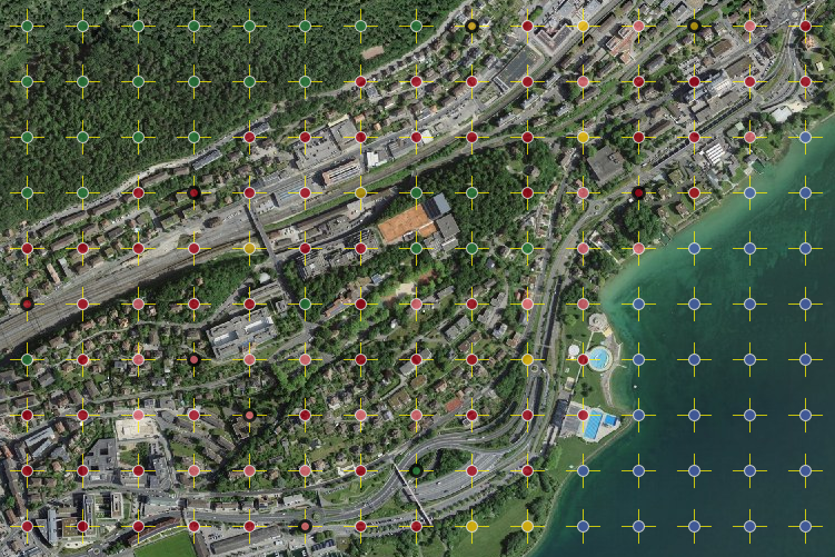
Visuelle Interpretation von in einem regelmässigen Gitter von 100 m angeordneten Stichprobenpunkten auf digitalen Luftbildern an einer photogrammetrischen Auswertungsstation anhand eines standardisierten Nutzungskatalogs.
Interprétation visuelle des points d'échantillonage d'un réseau équidistant de 100 m sur des photographies aériennes digitales utilisant des stations photogrammétriques et un catalogue de catégories standardisées.
-
NiveauLivelloHierarchy levelHierarchy levelBezugsebene
-
Jeu de donnéesSet di datiDatasetDatasetDatenbestand
-
DescriptionDescrizioneDescriptionDescriptionBeschreibung
-
Hauptgrundlage für die Bestimmung der Bodennutzung sind eingescannte, digitalisierte Luftbilder des Bundesamts für Landestopografie (swisstopo) der Jahre 1979-85, 1992-97 sowie 2004-09. Zur Qualitätssicherung und Erleichterung der Interpretation werden soweit verfügbar Zusatzinformationen, beispielsweise Landeskarten, Stadtpläne, Gebäudeinformationen des Eidg. Gebäude- und Wohnungsregisters, Schutzgebiete, Naturkatastrophen und dergleichen beigezogen. Nach der Luftbildinterpretation werden ausgewählte und besonders schwierig zu beurteilende Gebiete und Stichprobenpunkte im Gelände aufgesucht und verifiziert (Feldbegehungen). Für die Durchführung reliefabhängiger geometrischer Korrekturen kommt das Geländemodell DHM25 von swisstopo zum Einsatz.
Le relevé s'appuie principalement sur les photographies aériennes digitalisées (scannées) de l'Office fédéral de topographie (swisstopo) des années 1979-85, 1992-97 et 2004-09. Pour garantir la qualité des résultats, et pour faciliter l'interprétation des images, on a recours, là où c'était possible, à des sources d'information supplémentaires (cartes nationales, plans de villes, informations reliées à des bâtiments du registre fédéral des bâtiments et des logements, zones protégées, catastrophes naturelles, etc.). Après l'interprétation des images aériennes, des vérifications sont effectuées sur le terrain pour certaines zones ou certains points d'échantillonnage particulièrement difficiles à interpréter. Pour les corrections en fonction de la géométrie du relief, on utilise le modèle de terrain DHM25 de swisstopo.
-
Nom du système de référenceNome del sistema di riferimentoReference system identifierReference system identifierName des Referenzsystems
- EPSG:2056
-
Fréquence de mise à jourFrequenza di aggiornamentoMaintenance and update frequencyMaintenance and update frequencyWartungsintervall
-
Comme nécessaireSecondo necessitàAs neededAs neededBei Bedarf
-
Remarque sur la mise à jourNota sull'aggiornamentoMaintenance noteMaintenance noteAnmerkung
-
Nachführung erfolgt, wenn Dokumentation fehlerhaft oder verbesserungsbedürftig.
Actualisation en cas de fautes ou des améliorations de la documentation
Metadata
-
Identifiant des métadonnéesIdentificativo della schedaMetadata identifierMetadata identifierIdentifikator des Metadatensatzes
- f0b56783-613d-4664-9216-98442ce1994d
-
LangueLinguaLanguageLanguageSprache
- Deutsch
-
Encodage de caractèresCodifica dei caratteriCharacter encodingCharacter encodingZeichenkodierung
-
Utf8UTF8UTF8UTF8Utf8
-
LangueLinguaLanguageLanguageSprache
- Français
-
Encodage de caractèresCodifica dei caratteriCharacter encodingCharacter encodingZeichenkodierung
-
Utf8UTF8UTF8UTF8Utf8
-
LangueLinguaLanguageLanguageSprache
- Italiano
-
Encodage de caractèresCodifica dei caratteriCharacter encodingCharacter encodingZeichenkodierung
-
Utf8UTF8UTF8UTF8Utf8
-
LangueLinguaLanguageLanguageSprache
- English
-
Encodage de caractèresCodifica dei caratteriCharacter encodingCharacter encodingZeichenkodierung
-
Utf8UTF8UTF8UTF8Utf8
-
LangueLinguaLanguageLanguageSprache
- Rumantsch
-
Encodage de caractèresCodifica dei caratteriCharacter encodingCharacter encodingZeichenkodierung
-
Utf8UTF8UTF8UTF8Utf8
Point de contact
Punto di contatto
Point of contact
Point of contact
Ansprechpartner
Type de ressource
Tipo di risorsa
Type of resource
Type of resource
Anwendungsbereich der Metadaten
-
Domaine d'application de la ressourceAmbito di applicazione della risorsaResource scopeResource scopeDomäne der Ressourcenanwendung
-
Jeu de donnéesSet di datiDatasetDatasetDatenbestand
-
Lien vers la métadonnéeCollegamento ai metadatiMetadata linkageMetadata linkageLink zu den Metadaten
-
Informations de date (Création)Informazioni sulla data (Creazione)Date info (Creation)Date info (Creation)Datumsangaben (Erstellung)
- 2024-07-02T07:25:07.739Z
-
Informations de date (Révision)Informazioni sulla data (Revisione)Date info (Revision)Date info (Revision)Datumsangaben (Aktualisierung)
- 2026-04-13T09:42:13.879582Z
Norme des métadonnées
Standard dei metadati
Metadata standard
Metadata standard
Metadatenstandard
-
TitreTitoloTitleTitleTitel
-
eCH-0271