geocat.ch
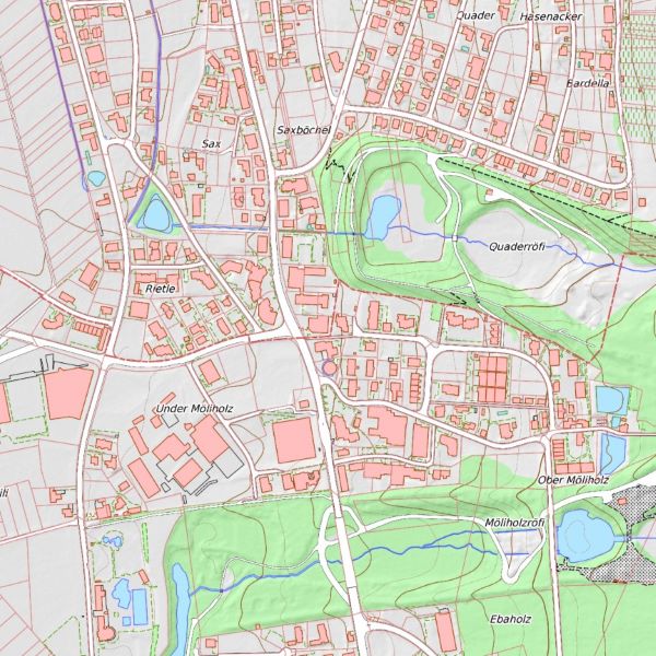
Base plan 1:5,000 (coloured) Liechtenstein
Coloured base plan of Liechtenstein at a scale of 1:5,000. The ‘BP-AV’ cadastral survey base plan is a product that is automatically derived from the digital data of the AV. With the exception of the depiction of rocks, which are taken directly from the 1:25,000 national map of Switzerland. The contour lines are derived from the digital terrain model. The equidistance of the contour lines is 10 metres and the equidistance of the intermediate contour lines is 5 metres. The relief is also calculated from the digital terrain model.
Simple
- Date (Publication)
- 2026-02-11
- Identifier
- https://metadata.geo.llv.li/efe2e834-57aa-4f25-a51f-ff8edac1a388
- Purpose
-
Basic data, overview plan, reference data
- Status
- On going
Point of contact
- Hours of service
-
8:00-11:30 und 13:30-17:00
- Spatial representation type
- Grid
Spatial resolution
- Spatial resolution
- 0.25 m
- Topic category
-
- A Imagery base maps earth cover
Extent
Extent
- Description
-
Liechtenstein
))

- Maintenance and update frequency
- Unknown
Resource format
- Title
-
GeoTIFF (GEOTIFF)
- Date
- geocat.ch
-
-
OpenData
-
basis plan
-
national map
-
- Räumlicher Anwendungsbereich
-
-
National
-
- geocat.ch
-
-
OpenData
-
national map
-
- GEMET
-
-
map chart
-
Resource constraints
- Use limitation
-
keine
- Access constraints
- Other restrictions
- Use constraints
- Other restrictions
- Other constraints
- No limitations to public access
Resource constraints
- Access constraints
- Other restrictions
- Use constraints
- Other restrictions
- Other constraints
- No conditions to access and use
- Other constraints
- Opendata BY: Open use. Must provide the source.
- Language
- Deutsch
- Character encoding
- UTF8
- Subtopic Category
- A1 Base Maps, Landscape Models
- Attribute description
- RGB-Farbwert
- Distribution format
-
-
Tagged Image File Format (TIFF) Compressed LZW
-
Point of contact
- Hours of service
-
8:00-11:30 und 13:30-17:00
Digital transfer options
- Units of distribution
-
1 Kachel
- OnLine resource
-
Geodatenportal
Geodata Portal of the National Administration
Digital transfer options
- Units of distribution
-
1 Kachel
- OnLine resource
-
DE#DE#DE#li.abi.basisplancol5|FR#|IT#|EN#|FR#|IT#|EN#|FR#|IT#|EN#
DE#Service der Liechtensteinischen Landesverwaltung|FR#|IT#|EN#
Digital transfer options
- Units of distribution
-
1 Kachel
- OnLine resource
-
Kachelweiser Download über das Geodatenportal
Tile guide download via the geodata portal
Digital transfer options
- Units of distribution
-
1 Kachel
- OnLine resource
-
OGC WMS Service der Liechtensteinischen Landesverwaltung
Public OGC-WMS Service of the National Administration
- Number of dimensions
- 2
- Cell geometry
- Area
- Transformation parameter availability
- 1
- Reference system identifier
- http://www.opengis.net/def/crs/EPSG/0/2056
- Maintenance and update frequency
- As needed
Metadata
- Metadata identifier
- efe2e834-57aa-4f25-a51f-ff8edac1a388
- Language
- Deutsch
- Character encoding
- UTF8
- Language
- Français
- Character encoding
- UTF8
- Language
- Italiano
- Character encoding
- UTF8
- Language
- English
- Character encoding
- UTF8
Point of contact
- Hours of service
-
8:00-11:30 und 13:30-17:00
Type of resource
- Resource scope
- Dataset
- Metadata linkage
-
https://www.geocat.ch/geonetwork/srv/api/records/efe2e834-57aa-4f25-a51f-ff8edac1a388
- Date info (Creation)
- 2024-05-24T08:18:56.655Z
- Date info (Revision)
- 2026-04-13T09:32:09.676481Z
Metadata standard
- Title
-
GM03 2+