geocat.ch
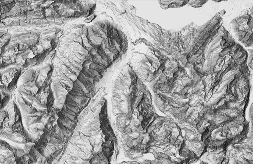
swissALTIRegio multidirectional Hillshade
The hillshade is derived from the digital elevation model swissALTIRegio. It illustrates the surface relief of Switzerland, the Principality of Liechtenstein and the neighbouring regions. A hillshade is derived from the elevation model by calculating the exposure of the surface to sunlight at a certain or several angles. The swissALTIRegio hillshade uses a multidirectional method that combines light from 6 different sources (sun's positions). The average sun's position is located to the northwest.
Simple
- Alternate title
-
swissALTIRegio multidirectional hillshade
- Date (Publication)
- 2023-12-31
- Date (Revision)
- 2023-12-31
- Identifier
- ch.swisstopo.swissaltiregio-reliefschattierung
Point of contact
- Spatial representation type
- Grid
Spatial resolution
- Spatial resolution
- 10 m
- Topic category
-
- C Elevation
Extent
Extent
- Description
-
swissALTIRegio
))

- Maintenance and update frequency
- Annually
- Maintenance note
-
A hillshade calculation is carried through on the updated parent data set.
- GEMET
-
-
digital land model
-
laser
-
relief (land)
-
geographic information system
-
- geocat.ch
-
-
laserscanning
-
3D visualisation
-
GIS (Geographic Information System)
-
DEM (digital elevation model)
-
LIDAR (Light Detection And Ranging)
-
3D simulation
-
- GEMET - INSPIRE themes, version 1.0
-
-
Elevation
-
- geocat.ch
-
-
FSDI Federal Spatial Data Infrastructure
-
Resource constraints
- Use constraints
- Other restrictions
- Other constraints
-
NonCommercialAllowed-CommercialAllowed-ReferenceRequired
Associated resource
- Title
-
Höhendaten (Landesvermessung)
- Association Type
- Reference to a master resource of which this one is a part
- Language
- Deutsch
- Character encoding
- UTF8
- Language
- English
- Character encoding
- UTF8
- Basic Geodata
- true
- Basic Geodata ID
-
41.6
- Basic Geodata Legal Level
- Federal
- Number of dimensions
- 2
- Cell geometry
- Point
- Transformation parameter availability
- 1
- Reference system identifier
- EPSG:2056
Metadata
- Metadata identifier
- ee980a56-7792-45c6-8b77-d6470ea91c72
- Language
- Deutsch
- Character encoding
- UTF8
- Language
- Français
- Character encoding
- UTF8
- Language
- Italiano
- Character encoding
- UTF8
- Language
- English
- Character encoding
- UTF8
- Language
- Rumantsch
- Character encoding
- UTF8
Point of contact
Type of resource
- Resource scope
- Dataset
- Metadata linkage
-
https://www.geocat.ch/geonetwork/srv/api/records/ee980a56-7792-45c6-8b77-d6470ea91c72
- Date info (Creation)
- 2023-11-13T16:34:43.422Z
- Date info (Revision)
- 2026-05-27T10:10:48.933117Z
Metadata standard
- Title
-
eCH-0271