 geocat.ch
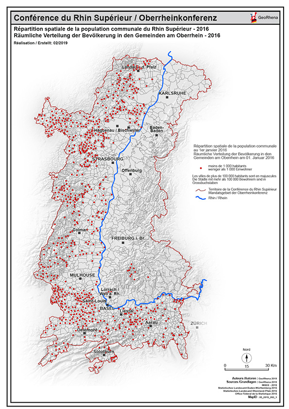
Répartition de la population de moins de 1 000 habitants 2016 PDF / Räumliche Verteilung der Bevölkerung mi weniger als 1 000 Einwohner - 2016 PDF
Carte PDF de la répartition spatiale de la population communale de moins de 1 000 habitants du Rhin Supérieur au 01/01/2016
PDF Karte der Räumliche Verteilung der Bevölkerung in den Gemeinden mit weniger als 1 000 Einwohner am Oberrhein am 01/01/2016
Simple
-
Date (Création)
- 2019-04-08
-
Forme de la présentation
-
Carte papier
-
État
-
Terminé
-
Catégorie de thème
-
-
M Société
-
Étendue
Étendue
N
S
E
W
))
-
Fréquence de mise à jour
-
Inconnue
- Keywords
-
-
über 50 000 Einwohner; plus de 50 000 habitants; répartition;population;PDF;carte;Karte;Rhin Supérieur;Rhin;Supérieur;2016;Bevölkerung;communale;Gemeinden;Verteilung;Räumliche;spatiale
-
Contraintes sur la ressource
-
Limitation d'utilisation
-
© OSM contributors - INSEE - STAL BW - STALA RP - OFS - GeoRhena
-
Contraintes d'accès
-
Droit d’auteur
-
Contraintes d'utilisation
-
Droit d’auteur
-
Langue
- Français
-
Format de distribution
-
-
PDF
-
Metadata
-
Identifiant des métadonnées
- eb7a14b4-2dfc-4add-98e8-7268c4624643
-
Langue
- Français
-
Encodage de caractères
-
Utf8
Type de ressource
-
Domaine d'application de la ressource
-
staticMap
-
Nom
-
1
-
Informations de date (Révision)
- 2025-06-18T14:57:02.391152Z
Norme des métadonnées
-
Titre
-
ISO 19115-3:2018
-
Édition
-
1.0
)))