geocat.ch
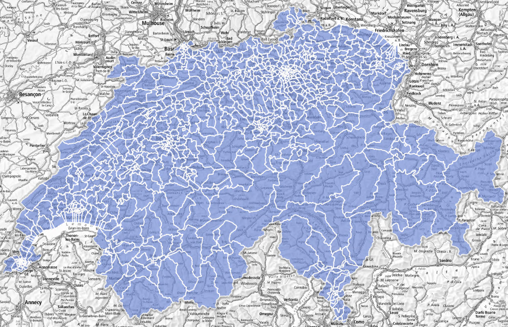
Basic spatial statistical units of the second level (USPAT2)
Second level basic statistical spatial units (USPAT2) of around 10 000 inhabitants are formed by grouping together USPAT1s or municipalities. These units make it possible to analyse the Swiss territory as a whole on the basis of entities of similar population size. Their size has been defined in such a way as to be able to potentially produce results of surveys with sufficient sample size.
Simple
- Alternate title
-
Basic statistical units level 2
- Date (Publication)
- 2024-06-28
- Identifier
- ch.bfs.statistische-grundeinheiten_stufe2
- Status
- Completed
Point of contact
- Topic category
-
- D Boundaries
Extent
Extent
- Description
-
Switzerland
))

- Maintenance and update frequency
- Irregular
- Duration of Conservation
- 100
- Appraisal of Archival Value
- N
Resource format
- Title
-
OGC Geopackage (GPKG)
- Date
Resource format
- Title
-
ESRI Shapefile (SHP)
- Date
- Keywords
-
-
Statistik; Grundeinheit
-
- geocat.ch
-
-
FSDI Federal Spatial Data Infrastructure
-
confederation
-
opendata.swiss
-
boundary line
-
Resource specific usage
- Specific usage
-
Kommerzielle Verwendung nur mit separater Vereinbarung
Resource constraints
- Use constraints
- Other restrictions
- Language
- Deutsch
- Character encoding
- UTF8
- Basic Geodata
- false
- Basic Geodata Legal Level
- Federal
- Distribution format
-
-
ESRI Shapefile (SHP)
-
OGC Geopackage (GPKG)
-
Digital transfer options
- OnLine resource
-
Geodaten (GeoPackage, Shapefile)
Digital transfer options
- OnLine resource
-
ch.bfs.statistische-grundeinheiten_stufe2
WMS-FSDI service, layer "Basic statistical units level 2"
Digital transfer options
- OnLine resource
-
ch.bfs.statistische-grundeinheiten_stufe2
WMTS-FSDI service, layer "Basic statistical units level 2"
Digital transfer options
- OnLine resource
-
RESTful API von geo.admin.ch
Digital transfer options
- OnLine resource
-
Vorschau map.geo.admin.ch
Digital transfer options
- OnLine resource
-
Datenbeschreibung
Digital transfer options
- OnLine resource
-
GEOSTAT
GEOSTAT ist das BFS-Kompetenzzentrum für Geoinformation und digitale Bildverarbeitung.
Digital transfer options
- OnLine resource
-
Variablenliste
I14Y Interoperability platform
- Geometric object type
- Surface
- Reference system identifier
- EPSG:2056
Metadata
- Metadata identifier
- eb6eb99f-7723-4e08-879f-286c3c670270
- Language
- Deutsch
- Character encoding
- UTF8
- Language
- Français
- Character encoding
- UTF8
- Language
- Italiano
- Character encoding
- UTF8
- Language
- English
- Character encoding
- UTF8
- Language
- Rumantsch
- Character encoding
- UTF8
Custodian
Type of resource
- Resource scope
- Dataset
- Metadata linkage
-
https://www.geocat.ch/geonetwork/srv/api/records/eb6eb99f-7723-4e08-879f-286c3c670270
- Date info (Creation)
- 2024-07-01T14:48:08.318Z
- Date info (Revision)
- 2026-06-15T07:20:14.183784Z
Metadata standard
- Title
-
eCH-0271