geocat.ch
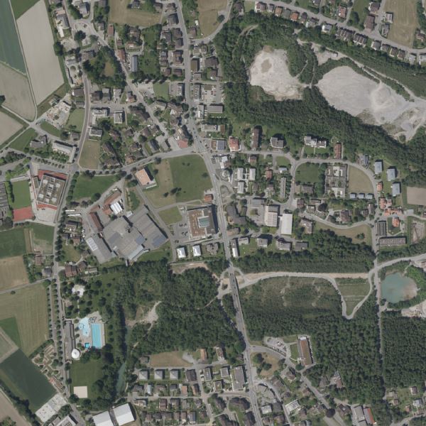
Orthophoto Liechtenstein 2022
Orthophoto mit einer Auflösung von 10 cm Bodenpixel. Die Befliegung wurde im Alpengebiet im Sommer, im Talgebiet im Winter durchgeführt. Die Befliegung im Winter hat den Vorteil, dass die Bodenabdeckungen durch Laub sehr gering sind.
Semplice
- Data (Pubblicazione)
- 2023-03-01
- Edizione
-
2022
- Identificatore
- https://metadata.geo.llv.li/e77da96f-bc1c-4317-8c2f-81310812c798
- Scopo
-
Grundlagedaten der GDI-Liechtenstein
- Stato
- Completato
Proprietario
- Orario di servizio
-
8:00-11:30 und 13:30-17:00
- Tipo di rappresentazione spaziale
- Raster
Risoluzione spaziale
- Distanza di risoluzione
- 0.1 m
- Categoria ISO
-
- A Mappe di base con immagini della copertura terrestre
Estensione
Estensione
- Descrizione
-
Liechtenstein
))

- Frequenza di aggiornamento
- Non pianificato
Formato della risorsa
- Titolo
-
GeoTIFF (GEOTIFF)
- Data
- geocat.ch
-
-
OpenData
-
INSPIRE
-
mosaico di ortofoto digitali a colori
-
ortofoto
-
- GEMET - INSPIRE themes, version 1.0
-
-
Orto immagini
-
- GEMET themes
-
-
ricerca
-
- Räumlicher Anwendungsbereich
-
-
Nazionali
-
Vincoli sulle risorse
- Limitazione d'uso
-
keine
- Vincoli di accesso
- Altre restrizioni
- Altri vincoli
- No limitations to public access
Vincoli sulle risorse
- Vincoli di accesso
- Altre restrizioni
- Vincoli d'uso
- Altre restrizioni
- Altri vincoli
- No conditions to access and use
- Lingua
- Deutsch
- Codifica dei caratteri
- UTF8
- Informazioni supplementari
-
Der Datensatz liegt in einzelnen Kacheln mit einer Grösse von 5 km2 vor
- Categoria di sottotema
- A1 Mappe di base, modelli paesaggistici
- Categoria di sottotema
- A3 Immagini aeree e satellitari
- Descrizione dell'attributo
- RGB-Farbwert
- Formato (codifica)
-
-
GeoTIFF (GEOTIFF)
-
Distributore
- Orario di servizio
-
8:00-11:30 und 13:30-17:00
Opzioni di trasferimento digitale
- Unità di distribuzione
-
1 Kachel oder indiv. Ausschnitte
- Risorsa online
-
Homepage ATG, Datenausgabe
Datenausgabestelle der Liechtensteinischen Landesverwaltung
Opzioni di trasferimento digitale
- Unità di distribuzione
-
1 Kachel oder indiv. Ausschnitte
- Risorsa online
-
Geodatenportal der Liechtensteinischen Landesverwaltung
Öfftentliche Online-Karten der Liechtensteinischen Landesverwaltung
Opzioni di trasferimento digitale
- Unità di distribuzione
-
1 Kachel oder indiv. Ausschnitte
- Risorsa online
-
OI.OrthoimageCoverage2022
INSPIRE View Service
Opzioni di trasferimento digitale
- Unità di distribuzione
-
1 Kachel oder indiv. Ausschnitte
- Risorsa online
-
li.abi.orthophoto2022
OGC WMS Service der Liechtensteinischen Landesverwaltung
Opzioni di trasferimento digitale
- Unità di distribuzione
-
1 Kachel oder indiv. Ausschnitte
- Risorsa online
-
INSPIRE Download Service (ATOM)
GML Download
Opzioni di trasferimento digitale
- Unità di distribuzione
-
1 Kachel oder indiv. Ausschnitte
- Risorsa online
-
Download als GeoTiff über das Geodatenportal
Download als GeoTiff über das Geodatenportal
- Livello
- Set di dati
Rapporto sulla qualità
Risultato
- Titolo
-
Commission Regulation (EU) No 1089/2010 of 23 November 2010 implementing Directive 2007/2/EC of the European Parliament and of the Council as regards interoperability of spatial data sets and services
- Data (Pubblicazione)
- 2010-12-08
- Spiegazione
-
Gemäss INSPIRE Bestandteil des Themas Orthofotografie
- Grado di conformità
- true
- Informazioni generali sulla provenienza
-
Luftbildbefliegung aus einer Flughöhe von ca. 2'200m? über Grund
- Livello
- Set di dati
- Descrizione
-
digitale Luftbilder
- Numero di dimensioni
- 2
- Geometria della cella
- Area
- Disponibilità dei parametri di trasformazione
- 1
- Nome del sistema di riferimento
- http://www.opengis.net/def/crs/EPSG/0/2056
- Nome del sistema di riferimento
- http://www.opengis.net/def/crs/EPSG/0/4936
- Frequenza di aggiornamento
- Secondo necessità
Metadati
- Identificativo della scheda
- e77da96f-bc1c-4317-8c2f-81310812c798
- Lingua
- Deutsch
- Codifica dei caratteri
- UTF8
- Lingua
- Français
- Codifica dei caratteri
- UTF8
- Lingua
- Italiano
- Codifica dei caratteri
- UTF8
- Lingua
- English
- Codifica dei caratteri
- UTF8
Punto di contatto
- Orario di servizio
-
8:00-11:30 und 13:30-17:00
Tipo di risorsa
- Ambito di applicazione della risorsa
- Set di dati
- Collegamento ai metadati
-
https://www.geocat.ch/geonetwork/srv/api/records/e77da96f-bc1c-4317-8c2f-81310812c798
- Informazioni sulla data (Creazione)
- 2023-04-14T08:21:07.899Z
- Informazioni sulla data (Revisione)
- 2026-04-13T09:31:19.529839Z
Standard dei metadati
- Titolo
-
eCH-0271