geocat.ch
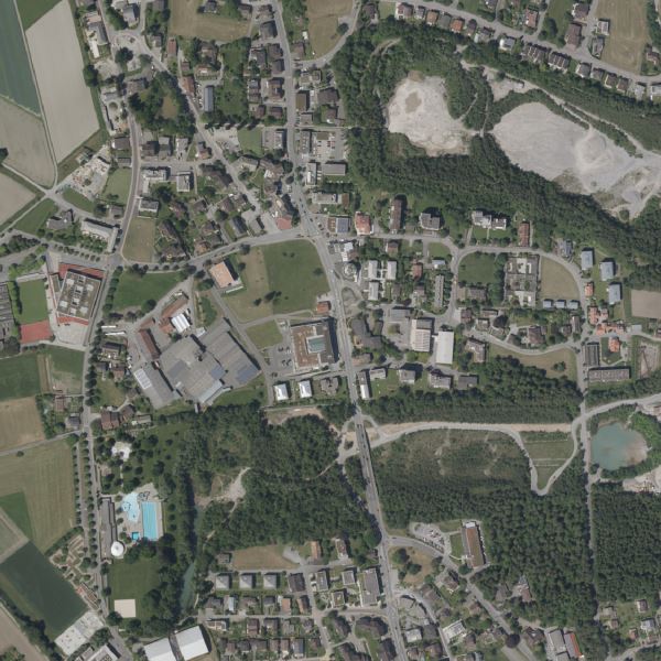
Orthophoto Liechtenstein 2022
Orthophoto with a resolution of 10 cm ground pixels. The aerial survey was carried out in the Alpine region in summer and in the valley region in winter. The advantage of flying in winter is that there is very little ground cover due to foliage.
Simple
- Date (Publication)
- 2023-03-01
- Edition
-
2022
- Identifier
- https://metadata.geo.llv.li/e77da96f-bc1c-4317-8c2f-81310812c798
- Purpose
-
Basic data of the GDI-Liechtenstein
- Status
- Completed
Owner
- Hours of service
-
8:00-11:30 und 13:30-17:00
- Spatial representation type
- Grid
Spatial resolution
- Spatial resolution
- 0.1 m
- Topic category
-
- A Imagery base maps earth cover
Extent
Extent
- Description
-
Liechtenstein
))

- Maintenance and update frequency
- Not planned
Resource format
- Title
-
GeoTIFF (GEOTIFF)
- Date
- geocat.ch
-
-
OpenData
-
INSPIRE
-
digital color orthophoto mosaic
-
orthophoto
-
- GEMET - INSPIRE themes, version 1.0
-
-
Orthoimagery
-
- GEMET themes
-
-
research
-
- Räumlicher Anwendungsbereich
-
-
National
-
Resource constraints
- Use limitation
-
keine
- Access constraints
- Other restrictions
- Other constraints
- No limitations to public access
Resource constraints
- Access constraints
- Other restrictions
- Use constraints
- Other restrictions
- Other constraints
- No conditions to access and use
- Other constraints
- Opendata BY: Open use. Must provide the source.
- Language
- Deutsch
- Character encoding
- UTF8
- Supplemental Information
-
Der Datensatz liegt in einzelnen Kacheln mit einer Grösse von 5 km2 vor
- Subtopic Category
- A1 Base Maps, Landscape Models
- Subtopic Category
- A3 Aerial and Satellite Imagery
- Attribute description
- RGB-Farbwert
- Distribution format
-
-
GeoTIFF (GEOTIFF)
-
Distributor
- Hours of service
-
8:00-11:30 und 13:30-17:00
Digital transfer options
- Units of distribution
-
1 Kachel oder indiv. Ausschnitte
- OnLine resource
-
Homepage ATG, Datenausgabe
data distribution office of the Liechtenstein National Administration
Digital transfer options
- Units of distribution
-
1 Kachel oder indiv. Ausschnitte
- OnLine resource
-
Geodatenportal der Liechtensteinischen Landesverwaltung
Public online maps of the Liechtenstein National Administration
Digital transfer options
- Units of distribution
-
1 Kachel oder indiv. Ausschnitte
- OnLine resource
-
OI.OrthoimageCoverage2022
INSPIRE View Service
Digital transfer options
- Units of distribution
-
1 Kachel oder indiv. Ausschnitte
- OnLine resource
-
li.abi.orthophoto2022
OGC WMS Service der Liechtensteinischen Landesverwaltung
Digital transfer options
- Units of distribution
-
1 Kachel oder indiv. Ausschnitte
- OnLine resource
-
INSPIRE Download Service (ATOM)
GML Download
Digital transfer options
- Units of distribution
-
1 Kachel oder indiv. Ausschnitte
- OnLine resource
-
Download als GeoTiff über das Geodatenportal
Download as GeoTiff via the geodata portal
- Hierarchy level
- Dataset
Report
Result
- Title
-
Commission Regulation (EU) No 1089/2010 of 23 November 2010 implementing Directive 2007/2/EC of the European Parliament and of the Council as regards interoperability of spatial data sets and services
- Date (Publication)
- 2010-12-08
- Explanation
-
Gemäss INSPIRE Bestandteil des Themas Orthofotografie
- Pass
- true
- Statement
-
Aerial survey from an altitude of approx. 2,200m? above ground level
- Hierarchy level
- Dataset
- Description
-
digitale Luftbilder
- Number of dimensions
- 2
- Cell geometry
- Area
- Transformation parameter availability
- 1
- Reference system identifier
- http://www.opengis.net/def/crs/EPSG/0/2056
- Reference system identifier
- http://www.opengis.net/def/crs/EPSG/0/4936
- Maintenance and update frequency
- As needed
Metadata
- Metadata identifier
- e77da96f-bc1c-4317-8c2f-81310812c798
- Language
- Deutsch
- Character encoding
- UTF8
- Language
- Français
- Character encoding
- UTF8
- Language
- Italiano
- Character encoding
- UTF8
- Language
- English
- Character encoding
- UTF8
Point of contact
- Hours of service
-
8:00-11:30 und 13:30-17:00
Type of resource
- Resource scope
- Dataset
- Metadata linkage
-
https://www.geocat.ch/geonetwork/srv/api/records/e77da96f-bc1c-4317-8c2f-81310812c798
- Date info (Creation)
- 2023-04-14T08:21:07.899Z
- Date info (Revision)
- 2026-04-13T09:31:19.529839Z
Metadata standard
- Title
-
eCH-0271