geocat.ch
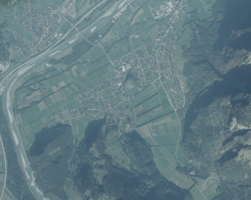
Orthophoto 1995
Farb-Orthophoto mit einer Auflösung von 75 cm Bodenpixel.
Die Qualität der Luftbilder ist leider eher mager, bei der Aufnahme haben offenbar Dunst oder Wolken die Sicht auf den Boden eingeschränkt
Semplice
- Data (Creazione)
- 1995-12-31
- Edizione
-
1995
- Identificatore
- https://metadata.geo.llv.li/e5fc2fe2-8cc3-4bc3-9ca6-61613f932024
- Scopo
-
Grundlagedaten der GDI-Liechtenstein
- Stato
- Completato
Proprietario
- Orario di servizio
-
8:00-11:30 und 13:30-17:00
- Tipo di rappresentazione spaziale
- Raster
Risoluzione spaziale
- Distanza di risoluzione
- 0.1 m
- Categoria ISO
-
- A Mappe di base con immagini della copertura terrestre
Estensione
Estensione
- Descrizione
-
Liechtenstein
))

- Frequenza di aggiornamento
- Non pianificato
Formato della risorsa
- Titolo
-
GeoTIFF (GEOTIFF)
- Data
- geocat.ch
-
-
INSPIRE
-
ortofoto
-
mosaico di ortofoto digitali a colori
-
- GEMET - INSPIRE themes, version 1.0
-
-
Orto immagini
-
- GEMET themes
-
-
ricerca
-
- Räumlicher Anwendungsbereich
-
-
Nazionali
-
Vincoli sulle risorse
- Vincoli di accesso
- Altre restrizioni
- Altri vincoli
- no limitations to public access
- Paese
- LI
- Tipo di legislazione
- Ordinanza
- Livello della disposizione legale
- national
- Titolo
-
Verordnung vom 30. August 2011 über die Gebühren für die Nutzung der Geodateninfrastruktur Liechtenstein
- Altri nomi o acronimi
-
GDI-Gebührenverordnung (GDI-GebV)
- Data (Creazione)
- 2011-08-30
- Data (Revisione)
- 2018-12-01
Vincoli sulle risorse
- Limitazione d'uso
-
Zugangs- und Nutzungsbedingungen
- Vincoli d'uso
- Altre restrizioni
- Altri vincoli
-
gebührenpflichtig
- Lingua
- Deutsch
- Codifica dei caratteri
- UTF8
- Informazioni supplementari
-
Der Datensatz liegt in einzelnen Kacheln mit einer Grösse von 5 km2 vor
- Categoria di sottotema
- A1 Mappe di base, modelli paesaggistici
- Categoria di sottotema
- A3 Immagini aeree e satellitari
- Descrizione dell'attributo
- RGB-Farbwert
- Formato (codifica)
-
-
GeoTIFF (GEOTIFF)
-
Distributore
- Orario di servizio
-
8:00-11:30 und 13:30-17:00
Opzioni di trasferimento digitale
- Unità di distribuzione
-
1 Kachel oder indiv. Ausschnitte
- Risorsa online
-
Homepage ATG, Datenausgabe
Datenausgabestelle der Liechtensteinischen Landesverwaltung
Opzioni di trasferimento digitale
- Unità di distribuzione
-
1 Kachel oder indiv. Ausschnitte
- Risorsa online
-
Geodatenportal der Liechtensteinischen Landesverwaltung
Öfftenliche Online-Karten der Liechtensteinischen Landesverwaltung
Opzioni di trasferimento digitale
- Unità di distribuzione
-
1 Kachel oder indiv. Ausschnitte
- Risorsa online
-
OGC WMS Service der Liechtensteinen Landesverwaltung
OGC WMS Service der Liechtensteinen Landesverwaltung
Opzioni di trasferimento digitale
- Unità di distribuzione
-
1 Kachel oder indiv. Ausschnitte
- Risorsa online
-
OGC WMS Service der Liechtensteinen Landesverwaltung
OGC WMS Service der Liechtensteinen Landesverwaltung
- Livello
- Set di dati
Rapporto sulla qualità
Risultato
- Titolo
-
VERORDNUNG (EG) Nr. 1089/2010 DER KOMMISSION vom 23. November 2010 zur Durchführung der Richtlinie 2007/2/EG des Europäischen Parlaments und des Rates hinsichtlich der Interoperabilität von Geodatensätzen und -diensten
- Data (Pubblicazione)
- 2010-12-08
- Spiegazione
-
Gemäss INSPIRE Bestandteil des Themas Orthofotografie
- Grado di conformità
- false
- Informazioni generali sulla provenienza
-
Luftbildbefliegung aus einer Flughöhe von ca. 2'200m? über Grund
- Livello
- Set di dati
- Descrizione
-
digitale Luftbilder
- Numero di dimensioni
- 2
- Geometria della cella
- Area
- Disponibilità dei parametri di trasformazione
- 1
- Nome del sistema di riferimento
- http://www.opengis.net/def/crs/EPSG/0/2056
- Nome del sistema di riferimento
- http://www.opengis.net/def/crs/EPSG/0/4936
- Frequenza di aggiornamento
- Secondo necessità
Metadati
- Identificativo della scheda
- e5fc2fe2-8cc3-4bc3-9ca6-61613f932024
- Lingua
- Deutsch
- Codifica dei caratteri
- UTF8
- Lingua
- Français
- Codifica dei caratteri
- UTF8
- Lingua
- Italiano
- Codifica dei caratteri
- UTF8
- Lingua
- English
- Codifica dei caratteri
- UTF8
Autore
- Orario di servizio
-
8:00-11:30 und 13:30-17:00
Tipo di risorsa
- Ambito di applicazione della risorsa
- Set di dati
- Collegamento ai metadati
-
https://www.geocat.ch/geonetwork/srv/api/records/e5fc2fe2-8cc3-4bc3-9ca6-61613f932024
- Informazioni sulla data (Creazione)
- 2023-04-17T14:28:39.022Z
- Informazioni sulla data (Revisione)
- 2026-05-05T12:36:45.624908Z
Standard dei metadati
- Titolo
-
eCH-0271