geocat.ch
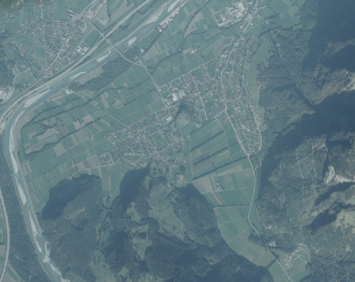
Orthophoto 1995
Farb-Orthophoto mit einer Auflösung von 75 cm Bodenpixel.
Die Qualität der Luftbilder ist leider eher mager, bei der Aufnahme haben offenbar Dunst oder Wolken die Sicht auf den Boden eingeschränkt
Simple
- Date (Creation)
- 1995-12-31
- Edition
-
1995
- Identifier
- https://metadata.geo.llv.li/e5fc2fe2-8cc3-4bc3-9ca6-61613f932024
- Purpose
-
Grundlagedaten der GDI-Liechtenstein
- Status
- Completed
Owner
- Hours of service
-
8:00-11:30 und 13:30-17:00
- Spatial representation type
- Grid
Spatial resolution
- Spatial resolution
- 0.1 m
- Topic category
-
- A Imagery base maps earth cover
Extent
Extent
- Description
-
Liechtenstein
))

- Maintenance and update frequency
- Not planned
Resource format
- Title
-
GeoTIFF (GEOTIFF)
- Date
- geocat.ch
-
-
INSPIRE
-
orthophoto
-
digital color orthophoto mosaic
-
- GEMET - INSPIRE themes, version 1.0
-
-
Orthoimagery
-
- GEMET themes
-
-
research
-
- Räumlicher Anwendungsbereich
-
-
National
-
Resource constraints
- Access constraints
- Other restrictions
- Other constraints
- no limitations to public access
- Country
- LI
- Legislation Type
- Ordinance
- Legislation Level
- national
- Title
-
Verordnung vom 30. August 2011 über die Gebühren für die Nutzung der Geodateninfrastruktur Liechtenstein
- Alternate title
-
GDI-Gebührenverordnung (GDI-GebV)
- Date (Creation)
- 2011-08-30
- Date (Revision)
- 2018-12-01
Resource constraints
- Use limitation
-
Zugangs- und Nutzungsbedingungen
- Use constraints
- Other restrictions
- Other constraints
-
gebührenpflichtig
- Language
- Deutsch
- Character encoding
- UTF8
- Supplemental Information
-
Der Datensatz liegt in einzelnen Kacheln mit einer Grösse von 5 km2 vor
- Subtopic Category
- A1 Base Maps, Landscape Models
- Subtopic Category
- A3 Aerial and Satellite Imagery
- Attribute description
- RGB-Farbwert
- Distribution format
-
-
GeoTIFF (GEOTIFF)
-
Distributor
- Hours of service
-
8:00-11:30 und 13:30-17:00
Digital transfer options
- Units of distribution
-
1 Kachel oder indiv. Ausschnitte
- OnLine resource
-
Homepage ATG, Datenausgabe
Datenausgabestelle der Liechtensteinischen Landesverwaltung
Digital transfer options
- Units of distribution
-
1 Kachel oder indiv. Ausschnitte
- OnLine resource
-
Geodatenportal der Liechtensteinischen Landesverwaltung
Öfftenliche Online-Karten der Liechtensteinischen Landesverwaltung
Digital transfer options
- Units of distribution
-
1 Kachel oder indiv. Ausschnitte
- OnLine resource
-
OGC WMS Service der Liechtensteinen Landesverwaltung
OGC WMS Service der Liechtensteinen Landesverwaltung
Digital transfer options
- Units of distribution
-
1 Kachel oder indiv. Ausschnitte
- OnLine resource
-
OGC WMS Service der Liechtensteinen Landesverwaltung
OGC WMS Service der Liechtensteinen Landesverwaltung
- Hierarchy level
- Dataset
Report
Result
- Title
-
VERORDNUNG (EG) Nr. 1089/2010 DER KOMMISSION vom 23. November 2010 zur Durchführung der Richtlinie 2007/2/EG des Europäischen Parlaments und des Rates hinsichtlich der Interoperabilität von Geodatensätzen und -diensten
- Date (Publication)
- 2010-12-08
- Explanation
-
Gemäss INSPIRE Bestandteil des Themas Orthofotografie
- Pass
- false
- Statement
-
Luftbildbefliegung aus einer Flughöhe von ca. 2'200m? über Grund
- Hierarchy level
- Dataset
- Description
-
digitale Luftbilder
- Number of dimensions
- 2
- Cell geometry
- Area
- Transformation parameter availability
- 1
- Reference system identifier
- http://www.opengis.net/def/crs/EPSG/0/2056
- Reference system identifier
- http://www.opengis.net/def/crs/EPSG/0/4936
- Maintenance and update frequency
- As needed
Metadata
- Metadata identifier
- e5fc2fe2-8cc3-4bc3-9ca6-61613f932024
- Language
- Deutsch
- Character encoding
- UTF8
- Language
- Français
- Character encoding
- UTF8
- Language
- Italiano
- Character encoding
- UTF8
- Language
- English
- Character encoding
- UTF8
Author
- Hours of service
-
8:00-11:30 und 13:30-17:00
Type of resource
- Resource scope
- Dataset
- Metadata linkage
-
https://www.geocat.ch/geonetwork/srv/api/records/e5fc2fe2-8cc3-4bc3-9ca6-61613f932024
- Date info (Creation)
- 2023-04-17T14:28:39.022Z
- Date info (Revision)
- 2026-05-05T12:36:45.624908Z
Metadata standard
- Title
-
eCH-0271