geocat.ch
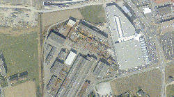
Orthophotos Chablais (2003)
Orthophotos sur demande de l'organe de surveillance cantonale de la mensuration officielle
Simple
- Alternate title
-
Orthophotos Chablais (2003)
- Date (Creation)
- 2003-06-30
- Identifier
- 414
- Purpose
-
Base pour la mise à jour du plan d'ensemble 1:10'000 et pour les travaux de préparation de la mensuration des surfaces agricoles utiles
- Status
- Historical archive
Custodian
- Spatial representation type
- Grid
Spatial resolution
- Spatial resolution
- 20 cm
- Topic category
-
- A Imagery base maps earth cover
Extent
Extent
- Description
-
Canton of Valais (VS)
))

- Maintenance and update frequency
- Not planned
Resource format
- Title
-
Tagged Image File Format (TIFF)
- Date
- geocat.ch
-
-
orthophoto
-
official geodata
-
Resource constraints
- Use limitation
-
Aucunes
Resource constraints
- Access constraints
- Other restrictions
- Other constraints
-
Géodonnées accessibles au public (niveau A selon l'OGéo)
- Other constraints
-
Les conditions générales d'utilisation des géodonnées du Canton du Valais font foi ( https://www.vs.ch/fr/web/guest/information-legale).
- Language
- Français
- Character encoding
- UTF8
- Environment description
-
S:\Géodonnées VS\A3 Images\Chablais 2003.lyr S:\Géodonnées VS\A3 Images\Chablais 2003 Index.lyr
- Subtopic Category
- A3 Aerial and Satellite Imagery
- Basic Geodata
- false
- Basic Geodata Legal Level
- Cantonal
- Basic Geodata Type
- Reference Geodata
- Distribution format
-
-
GeoTIFF (GEOTIFF)
-
Cloud Optimized GeoTIFF (TIFF / TIF)
-
Distributor
- Statement
-
Echelle des photos 1:12000 pour NT3 et 1:25'00 pour NT4 et 5
- Hierarchy level
- Dataset
- Description
-
Scannage avec 15 micromètre, MNT10 utilisé
- Reference system identifier
- EPSG:2056/CH1903+_MN95
Metadata
- Metadata identifier
- e5e44c28-a138-41ce-bb24-3e4bb56a0ec3
- Language
- Français
- Character encoding
- UTF8
- Language
- Deutsch
- Character encoding
- UTF8
- Language
- Italiano
- Character encoding
- UTF8
- Language
- English
- Character encoding
- UTF8
- Language
- Rumantsch
- Character encoding
- UTF8
Distributor
Type of resource
- Resource scope
- Dataset
- Metadata linkage
-
https://www.geocat.ch/geonetwork/srv/api/records/e5e44c28-a138-41ce-bb24-3e4bb56a0ec3
- Date info (Creation)
- 2019-08-23T13:06:07Z
- Date info (Revision)
- 2026-05-18T12:10:56.035184Z
Metadata standard
- Title
-
eCH-0271