 geocat.ch
Imagery Base Map weltweit (Vector Tile Style)
Imagery Base Map mondial (Vector Tile Style)
Imagery Base Map mondiale (Vector Tile Style)
Imagery Base Map worldwide (Vector Tile Style)
Imagery Base Map weltweit (Vector Tile Style)
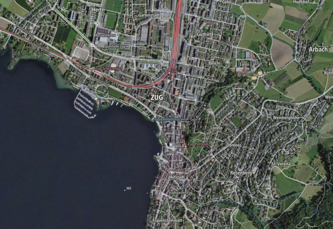
Die «Imagery Base Map» stellt dank einer Kombination aus Orthobildern (entzerrte Luftbilder) und kartografischen Elementen einen guten Überblick der gegenwärtigen Landschaft dar. Sie baut auf amtlichen Daten auf: dem topografischen Landschaftsmodell, dem digitalen Höhenmodell, den digitalen kartografischen Modellen und dem amtlichen Verzeichnis der Strassen. Der Inhalt variiert je nach Zoomstufe.
Die Vektordarstellung basiert auf der Maplibre Style Spezifikation. Vektorkacheln (Base Vector Tileset) bilden die Datengrundlage. Die Orthobilder (SWISSIMAGE) werden als Rasterkacheln dargestellt.
Im Ausland werden von openmaptiles.org zur Verfügung gestellte Vector Tiles aus OpenStreetMap verwendet.
L'«Imagery Base Map» présente une bonne vue d’ensemble du paysage actuel grâce à une combinaison d’orthophotos (prise de vue aériennes rectifiées) et d’éléments cartographiques. Elle est construite sur des données officielles: le modèle topographique du paysage, le modèle altimétrique numérique, les modèles cartographiques numériques et le répertoire officiel des rues.
La représentation vectorielle est basée sur la spécification Maplibre Style. Les tuiles vectorielles (Base Vector Tileset) constituent la base de données. Les ortho-images (SWISSIMAGE) sont affichées sous forme de tuiles matricielles.
Pour l'étranger, des tuiles vectorielles basées OpenStreetMap sont utilisées. Elles sont fournies par openmaptiles.org.
La «Imagery Base Map» fornisce una buona panoramica del paesaggio attuale attraverso una combinazione di ortofoto (fotografie aeree rettificate) ed elementi cartografici. Si basa su dati ufficiali: il modello topografico del paesaggio, il modello altimetrico digitale, i modelli cartografici digitali e l'elenco ufficiale delle strade.
La rappresentazione vettoriale è basata sulla specifica Maplibre Style. Le tessere vettoriali (Base Vector Tileset) costituiscono la base dei dati. Le ortoimmagini (SWISSIMAGE) sono visualizzate come piastrelle raster.
Per i paesi stranieri, vengono utilizzate piastrelle vettoriali basate su OpenStreetMap fornite da openmaptiles.org.
“Imagery Base Map” offers a good overview of the current landscape thanks to a combination of orthoimages (rectified aerial photographs) and cartographic elements. It is based on official data: the topographic landscape model, the digital elevation model, the digital cartographic models and the official index of roads. The content varies depending on the zoom level.
The vector representation is based on the Maplibre Style Specification. The data basis consists of vector tiles (Base Vector Tileset). The orthoimages (SWISSIMAGE) are displayed as raster tiles.
Vector tiles from OpenStreetMap provided by openmaptiles.org are used abroad.
Grazia ad ina cumbinaziun d'ortomaletgs (fotografias ord l'aria rectifitgadas) e d'elements cartografics preschenta la «Imagery Base Map» ina buna survista da la cuntrada actuala. Ella sa basa sin datas uffizialas: sin il model topografic da la cuntrada, sin il model digital da l'autezza, sin ils models cartografics digitals e sin il register uffizial da las vias. Il cuntegn variescha tut tenor il stgalim da zoom.
La preschentaziun vectoriala sa basa sin la specificaziun «Mapbox Style». Ils quadrels vectorials (englais: Vector Tiles) basan sin las datas da la Base Vector Tileset. Ils ortomaletgs (SWISSIMAGE) vegnan mussads sco quadrels da raster.
A l'exteriur vegnan duvrads «Vector Tiles» dad OpenStreetMap che vegnan mess a disposiziun dad openmaptiles.org.
Simple
-
Autre titreAltri nomi o acronimiAlternate titleAlternate titleAlternativtitel
-
Imagery Base Map World
Imagery Base Map World
Imagery Base Map World
Imagery Base Map World
Imagery Base Map World
-
Date (Création)Data (Creazione)Date (Creation)Date (Creation)Datum (Erstellung)
- 2021-04-01
-
Date (Révision)Data (Revisione)Date (Revision)Date (Revision)Datum (Aktualisierung)
- 2024-03-01
-
IdentifiantIdentificatoreIdentifierIdentifierKennung
- ch.swisstopo.imagerybasemap_world.vt
-
ÉtatStatoStatusStatusBearbeitungsstatus
-
ContinuIn corsoOn goingOn goingKontinuierliche Aktualisierung
Point de contact
Punto di contatto
Point of contact
Point of contact
Ansprechpartner
Propriétaire
Proprietario
Owner
Owner
Eigentümer
-
Type de représentation spatialeTipo di rappresentazione spazialeSpatial representation typeSpatial representation typeRäumliche Darstellungsart
-
vecteurVettorialeVectorVectorVektor
Résolution spatiale
Risoluzione spaziale
Spatial resolution
Spatial resolution
Räumliche Auflösung
Fraction représentative
Frazione rappresentativa
Equivalent scale
Equivalent scale
Vergleichsmassstab
-
DénominateurDenominatoreDenominatorDenominatorMassstabszahl
- 5000
Résolution spatiale
Risoluzione spaziale
Spatial resolution
Spatial resolution
Räumliche Auflösung
Fraction représentative
Frazione rappresentativa
Equivalent scale
Equivalent scale
Vergleichsmassstab
-
DénominateurDenominatoreDenominatorDenominatorMassstabszahl
- 1000000
-
Catégorie de thèmeCategoria ISOTopic categoryTopic categoryThematik
-
-
A Imagerie, cartes de base et occupation du solA Mappe di base con immagini della copertura terrestreA Imagery base maps earth coverA Imagery base maps earth coverA Oberflächenbeschreibung
-
Étendue
Estensione
Extent
Extent
Ausdehnung
Étendue
Estensione
Extent
Extent
Ausdehnung
-
DescriptionDescrizioneDescriptionDescriptionBeschreibung
-
National map 1:1'000'000
Landeskarte 1:1'000'000
Carte nationale 1:1'000'000
Carta nazionale 1:1'000'000
Landeskarte 1:1'000'000
-
Identifiant géographiqueIdentificatore geograficoGeographic identifierGeographic identifierGeografische Kennung
- NM1000LK1000CN1000CN1000LK1000
))

-
Fréquence de mise à jourFrequenza di aggiornamentoMaintenance and update frequencyMaintenance and update frequencyWartungsintervall
-
Comme nécessaireSecondo necessitàAs neededAs neededBei Bedarf
- geocat.ch
-
-
orthophoto
ortofoto
orthophoto
-
carte de base
carta di base
base map
-
géodonnées de base
geodati di base
official geodata
-
IFDG l’Infrastructure Fédérale de données géographiques
IFDG Infrastruttura federale dei dati geografici
FSDI Federal Spatial Data Infrastructure
-
- GEMET - INSPIRE themes, version 1.0
-
-
Ortho-imagerie
Orto immagini
Orthoimagery
-
Dénominations géographiques
Nomi geografici
Geographical names
-
Contraintes sur la ressource
Vincoli sulle risorse
Resource constraints
Resource constraints
Ressourcenbeschränkungen
-
Limitation d'utilisationLimitazione d'usoUse limitationUse limitationNutzungsbeschränkung
-
Es gelten die Nutzungsbedingungen für kostenlose Geodaten und Geodienste (OGD) von swisstopo und die Allgemeinen Nutzungsbedingungen und Betriebsbestimmungen der Bundes Geodaten-Infrastruktur BGDI.
Bei digitalen oder analogen Darstellungen und Publikationen ist die folgende Quellenangabe anzubringen: © swisstopo, © OpenStreetMap contributors, © maptiler
Nutzungseinschränkung:
Der Geodienst «Mapbox Vector Tiles» unterliegt einer Nutzungseinschränkung aufgrund der Verwendung von OpenMaptiles-Daten. Die weltweiten Daten können aus Lizenzgründen nur durch Verwaltungseinheiten der zentralen Bundesverwaltung gemäss der Anhang 1 der Regierungs- und Verwaltungsorganisationsverordnung (Anhang 1 RVOV, SR 172.010.1) genutzt werden. Für Nutzer ausserhalb der Bundesverwaltung stehen die Vector Tilesets innerhalb der Schweiz und Liechtenstein kostenlos als Dienst zur Verfügung.
Les conditions d'utilisation des géodonnées et géoservices gratuits (OGD) de swisstopo ainsi que les conditions générales d'utilisation et d'exploitation de l'infrastructure fédérale de données géographiques (IFDG) s'appliquent.
Les représentations et publications numériques ou analogiques doivent mentionner la source suivante : © swisstopo, © OpenStreetMap contributors, © maptiler
Restriction d’utilisation :
Le géoservice « Mapbox Vector Tiles » est soumis à une restriction d’utilisation en raison de l’utilisation des données OpenMaptiles. Pour des raisons de licence, les données mondiales ne peuvent être utilisées que par des unités administratives de l'administration fédérale centrale, conformément à l'annexe 1 de l'ordonnance sur l'organisation du gouvernement et de l'administration (annexe 1 OLOGA, RS 172.010.1). Pour les utilisateurs en dehors de l’administration fédérale, les vector tilesets (jeux de tuiles vectorielles) sont disponibles gratuitement en Suisse et au Liechtenstein.
Si applicano le condizioni di utilizzo per i geodati e i geoservizi gratuiti (OGD) di swisstopo e le condizioni generali di utilizzo e al regolamento di esercizio dell'Infrastruttura federale di dati geografici IFDG.
Le rappresentazioni e le pubblicazioni digitali o analogiche devono contenere il seguente riferimento alla fonte: © swisstopo, © OpenStreetMap contributors, © maptiler
Limitazione d’uso:
Il geoservizio «Mapbox Vector Tiles» è soggetto a una limitazione d’uso per via dell’utilizzo dei dati OpenMaptiles. Per motivi di licenza, i dati globali possono essere usati solo dalle unità amministrative dell'Amministrazione federale centrale in conformità all'Allegato 1 dell'Ordinanza sull'organizzazione del governo e dell'amministrazione (Allegato 1 OLOGA, RS 172.010.1). Per gli utenti al di fuori dell’Amministrazione federale, i vector tileset sono disponibili gratuitamente quale servizio all’interno della Svizzera e del Principato del Liechtenstein.
The terms of use for free geodata and geoservices (OGD) from swisstopo apply, as do the general terms of use and operating regulations of the federal spatial data infrastructure FSDI.
For digital or analogue representations and publications, the following source reference must be included: © swisstopo, © OpenStreetMap contributors, © maptiler
Restrictions of use:
The "Mapbox Vector Tiles" geoservice has usage restrictions imposed due to the incorporation of OpenMaptiles data. As per licensing requirements, the global data can only be utilised by administrative units of the Swiss central federal administration, following specification in Annex 1 of the Government and Administration Organisation Ordinance (Annex 1 RVOV, SR 172.010.1). However, users outside the Federal Administration can access the vector tilesets covering Switzerland and Liechtenstein provided by swisstopo free of charge.
-
Contraintes d'utilisationVincoli d'usoUse constraintsUse constraintsNutzungseinschränkungen
-
Autres restrictionsAltre restrizioniOther restrictionsOther restrictionsAndere Beschränkungen
-
Autres contraintesAltri vincoliOther constraintsOther constraintsAndere Einschränkungen
- Nutzungsbedingungen für kostenlose Geodaten und Geodienste (OGD) von swisstopoConditions d'utilisation des géodonnées et géoservices gratuits (OGD) de swisstopoCondizioni di utilizzo per i geodati e i geoservizi gratuiti (OGD) di swisstopoTerms of use for free geodata and geoservices (OGD) from swisstopo
-
Autres contraintesAltri vincoliOther constraintsOther constraintsAndere Einschränkungen
- Allgemeine Nutzungsbedingungen der Bundes Geodaten-Infrastruktur BGDIConditions générales d’utilisation et d’exploitation de l’Infrastructure fédérale de données géographiques IFDGCondizioni generali di utilizzo e disposizioni operative dell’infrastruttura federale di dati geografici (IFDG)General Terms of Use and Operating Conditions of the Federal Spatial Data Infrastructure FSDI
Ressource associée
Risorsa associata
Associated resource
Associated resource
Verlinkte Ressource
-
TitreTitoloTitleTitleTitel
-
Landesvermessung
mensuration nationale
misurazione nazionale
National survey
-
Type d'associationTipo di associazioneAssociation TypeAssociation TypeAssoziationstyp
-
Citation de travail plus largeCitazione di un'opera più ampiaReference to a master resource of which this one is a partReference to a master resource of which this one is a partÜbergeordneter Datenbestand
-
LangueLinguaLanguageLanguageSprache
- English
-
Encodage de caractèresCodifica dei caratteriCharacter encodingCharacter encodingZeichenkodierung
-
Utf8UTF8UTF8UTF8Utf8
-
Informations supplémentairesInformazioni supplementariSupplemental InformationSupplemental InformationZusätzliche Informationen
-
Weltweite Ausdehnung (siehe Nutzungseinschränkung)
Verwaltungseinheiten der zentralen Bundesverwaltung können bei swisstopo ( webgis@swisstopo.ch) einen Key für die Nutzung der Auslandgeodatendienste beantragen.
Extension mondiale (voir restriction d'utilisation)
Les unités de l'administration fédérale centrale peuvent demander à swisstopo ( webgis@swisstopo.ch) une key pour utiliser les services de géodonnées étrangers.
Espansione globale (vedi limitazioni d'uso)
Le unità amministrative dell’Amministrazione federale centrale possono richiedere a swisstopo ( webgis@swisstopo.ch) una key per l'utilizzo dei servizi di geodati esteri.
Global expansion (see restriction of use)
Units of the central federal administration can apply to swisstopo ( webgis@swisstopo.ch) for a key to access geodata services outside Switzerland.
-
Catégorie de sous-thèmeCategoria di sottotemaSubtopic CategorySubtopic CategoryThematische Unterkategorien
-
A1 Cartes de base, modèles de paysageA1 Mappe di base, modelli paesaggisticiA1 Base Maps, Landscape ModelsA1 Base Maps, Landscape ModelsA1 Basiskarten, Landschaftsmodelle
-
Géodonnées de baseGeodati di baseBasic GeodataBasic GeodataGeobasisdaten
- true
-
Identifiant Géodonnées de baseIdentificativo dei geodati di baseBasic Geodata IDBasic Geodata IDIdentifikator des Geobasisdatensatzes
-
42.18
-
Niveau des géodonnées de baseLivello legale dei geodati di baseBasic Geodata Legal LevelBasic Geodata Legal LevelGeobasisdatenebene
-
FédéralFederaleFederalFederalNational
-
Type de géodonnées de baseTipo di geodati di baseBasic Geodata TypeBasic Geodata TypeGeobasisdatentyp
-
Géodonnées de référenceGeodati di riferimentoReference GeodataReference GeodataGeoreferenzdaten
-
Format de distributionFormato (codifica)Distribution formatDistribution formatAbgabeformat
-
-
JavaScript Object Notation (JSON)
-
Options de transfert numérique
Opzioni di trasferimento digitale
Digital transfer options
Digital transfer options
Optionen für die digitale Übertragung
Options de transfert numérique
Opzioni di trasferimento digitale
Digital transfer options
Digital transfer options
Optionen für die digitale Übertragung
Options de transfert numérique
Opzioni di trasferimento digitale
Digital transfer options
Digital transfer options
Optionen für die digitale Übertragung
-
Ressource en ligneRisorsa onlineOnLine resourceOnLine resourceOnline
-
Download Vector Tile Style
Options de transfert numérique
Opzioni di trasferimento digitale
Digital transfer options
Digital transfer options
Optionen für die digitale Übertragung
-
Nom du système de référenceNome del sistema di riferimentoReference system identifierReference system identifierName des Referenzsystems
- EPSG:3857
Metadata
-
Identifiant des métadonnéesIdentificativo della schedaMetadata identifierMetadata identifierIdentifikator des Metadatensatzes
- e192e265-7bd3-4897-9291-3febcf19aad3
-
LangueLinguaLanguageLanguageSprache
- Deutsch
-
Encodage de caractèresCodifica dei caratteriCharacter encodingCharacter encodingZeichenkodierung
-
Utf8UTF8UTF8UTF8Utf8
-
LangueLinguaLanguageLanguageSprache
- Français
-
Encodage de caractèresCodifica dei caratteriCharacter encodingCharacter encodingZeichenkodierung
-
Utf8UTF8UTF8UTF8Utf8
-
LangueLinguaLanguageLanguageSprache
- Italiano
-
Encodage de caractèresCodifica dei caratteriCharacter encodingCharacter encodingZeichenkodierung
-
Utf8UTF8UTF8UTF8Utf8
-
LangueLinguaLanguageLanguageSprache
- English
-
Encodage de caractèresCodifica dei caratteriCharacter encodingCharacter encodingZeichenkodierung
-
Utf8UTF8UTF8UTF8Utf8
-
LangueLinguaLanguageLanguageSprache
- Rumantsch
-
Encodage de caractèresCodifica dei caratteriCharacter encodingCharacter encodingZeichenkodierung
-
Utf8UTF8UTF8UTF8Utf8
Point de contact
Punto di contatto
Point of contact
Point of contact
Ansprechpartner
-
Heures de serviceOrario di servizioHours of serviceHours of serviceBetriebszeiten
-
08h30 - 11h00 / 14h00 - 16h00 GMT+1
Type de ressource
Tipo di risorsa
Type of resource
Type of resource
Anwendungsbereich der Metadaten
-
Domaine d'application de la ressourceAmbito di applicazione della risorsaResource scopeResource scopeDomäne der Ressourcenanwendung
-
Jeu de donnéesSet di datiDatasetDatasetDatenbestand
-
Lien vers la métadonnéeCollegamento ai metadatiMetadata linkageMetadata linkageLink zu den Metadaten
-
Informations de date (Création)Informazioni sulla data (Creazione)Date info (Creation)Date info (Creation)Datumsangaben (Erstellung)
- 2025-05-16T06:42:49.245Z
-
Informations de date (Révision)Informazioni sulla data (Revisione)Date info (Revision)Date info (Revision)Datumsangaben (Aktualisierung)
- 2026-04-13T09:28:14.451787Z
Norme des métadonnées
Standard dei metadati
Metadata standard
Metadata standard
Metadatenstandard
-
TitreTitoloTitleTitleTitel
-
eCH-0271
Overviews
Spatial extent

Provided by
