geocat.ch
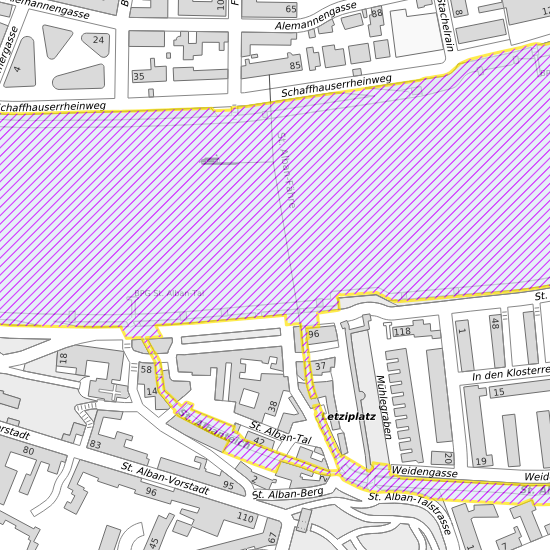
Gewässerraum
Der Kanton Basel-Stadt erarbeitet zurzeit für das gesamte Kantonsgebiet einen kantonalen Nutzungsplan, mit welchem der Gewässerraum – also der Raum, den die Gewässer und ihre Uferbereiche einnehmen – grundeigentümerverbindlich festgelegt wird. Mit dem Inkrafttreten des kantonalen Nutzungsplans wird der aktuell geltende Gewässerraum gemäss Übergangsbestimmungen abgelöst.
Simple
- Date (Creation)
- 2021-05-04
- Status
- Under development
Author
- Topic category
-
- E Planning cadastre
Extent
Extent
- Description
-
Basel-Stadt (BS)
))

- Maintenance and update frequency
- As needed
- GEMET
-
-
water (geographic)
-
Resource constraints
- Other constraints
-
Die Geodaten sind öffentlich zugänglich. (Zugangsberechtigungsstufe [A] = öffentlich)
- Other constraints
-
Es gelten die Nutzungsbedingungen für Geodaten des Kantons Basel-Stadt. ( http://www.geo.bs.ch/AGB)
Associated resource
- Association Type
- Reference to a master resource of which this one is a part
- Language
- Deutsch
- Character encoding
- UTF8
- Subtopic Category
- E1 Spatial Planning, Spatial Development
- Basic Geodata
- true
- Basic Geodata ID
-
190>A
- Basic Geodata Legal Level
- Federal
- Distribution format
-
-
ESRI Shapefile (SHP)
-
INTERLIS 2 (XTF)
-
ESRI File Geodatabase FileGDB (GDB)
-
OGC Geopackage (GPKG)
Digital transfer options
- OnLine resource
-
ÖREB-Kataster Basel-Stadt
Kataster der öffentlich rechtlichen Eigentumsbeschränkungen des Kantons Basel-Stadt
Digital transfer options
- OnLine resource
-
Öffentlich zugänglicher Geodaten-Downloaddienst des Kantons Basel-Stadt
- Reference system identifier
- CH1903+ / LV95/EPSG: 2056
Metadata
- Metadata identifier
- d8d6ae0b-93fd-481c-b827-ec4bd0aed66b
- Language
- Deutsch
- Character encoding
- UTF8
- Language
- Français
- Character encoding
- UTF8
- Language
- Italiano
- Character encoding
- UTF8
- Language
- English
- Character encoding
- UTF8
Custodian
Type of resource
- Resource scope
- Dataset
- Metadata linkage
-
https://www.geocat.ch/geonetwork/srv/api/records/d8d6ae0b-93fd-481c-b827-ec4bd0aed66b
- Date info (Creation)
- 2021-05-04T04:55:03Z
- Date info (Revision)
- 2026-04-13T09:40:06.315808Z
Metadata standard
- Title
-
eCH-0271