geocat.ch
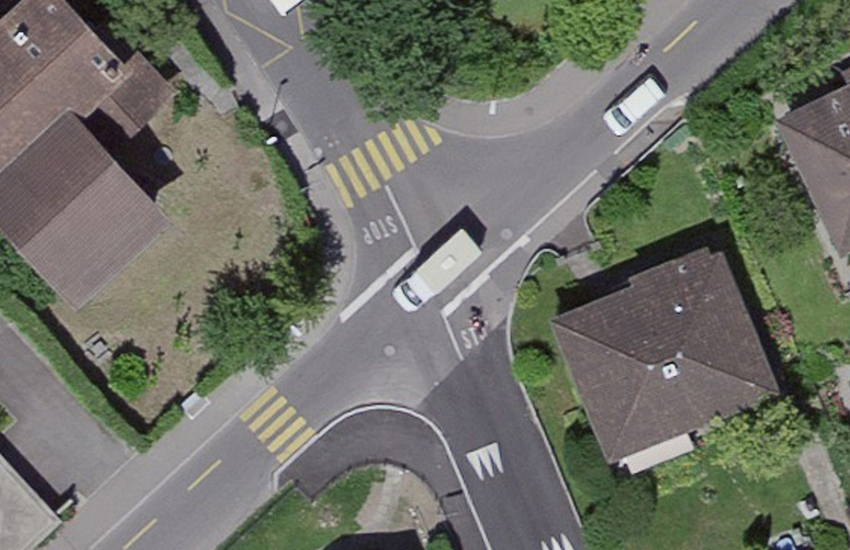
SWISSIMAGE 10 cm, digital orthophotomosaic of Switzerland
The orthophoto mosaic SWISSIMAGE 10 cm is a composition of new digital color aerial photographs over the whole of Switzerland with a ground resolution of 10 cm in the plain areas and main alpine valleys and 25 cm over the Alps. It is updated in a cycle of 3 years since 2018.
Simple
- Alternate title
-
SWISSIMAGE 10 cm Raster
- Date (Creation)
- 2018-01-01
- Identifier
- ch.swisstopo.swissimage-dop10
- Status
- On going
Point of contact
Federal Office of Topography swisstopo - geodata (Geodata Distribution)
Seftigenstrasse 264
Wabern
3084
CH
- Spatial representation type
- Grid
- Topic category
-
- A Imagery base maps earth cover
Extent
Extent
- Description
-
SWISSIMAGE 10 cm
- Geographic identifier
- SWISSIMAGE 10 cm
N
S
E
W
))

- Maintenance and update frequency
- Unknown
- geocat.ch
-
-
orthophoto
-
digital color orthophoto mosaic
-
e-geo.ch
-
opendata.swiss
-
- GEMET
-
-
aerial photograph
-
- GEMET - INSPIRE themes, version 1.0
-
-
Orthoimagery
-
- geocat.ch
-
-
FSDI Federal Spatial Data Infrastructure
-
Resource constraints
- Other constraints
- Opendata BY: Open use. Must provide the source.
Associated resource
- Association Type
- Reference to a master resource of which this one is a part
- Metadata Reference
Associated resource
- Association Type
- Reference to a master resource of which this one is a part
- Metadata Reference
- Language
- Deutsch
- Subtopic Category
- A3 Aerial and Satellite Imagery
- Distribution format
-
-
GeoTIFF (GEOTIFF)
-
Digital transfer options
Digital transfer options
- Number of dimensions
- 2
- Cell geometry
- Area
- Transformation parameter availability
- false
- Reference system identifier
- EPSG:2056
Metadata
- Metadata identifier
- d8864f44-7392-47b5-ad0e-cf1d52d156ac
- Language
- Deutsch
- Character encoding
- UTF8
- Language
- Français
- Character encoding
- UTF8
- Language
- Italiano
- Character encoding
- UTF8
- Language
- English
- Character encoding
- UTF8
- Language
- Rumantsch
- Character encoding
- UTF8
Point of contact
Federal Office of Topography swisstopo - metadata (Metadata contact)
Seftigenstrasse 264
Wabern
3084
CH
Type of resource
- Resource scope
- Dataset
- Metadata linkage
-
https://www.geocat.ch/geonetwork/srv/api/records/d8864f44-7392-47b5-ad0e-cf1d52d156ac
- Date info (Creation)
- 2020-12-16T09:41:27Z
- Date info (Revision)
- 2026-04-13T09:30:43.247756Z
Metadata standard
- Title
-
eCH-0271