geocat.ch
Lithological and mineralogical map of Switzerland 1:200000
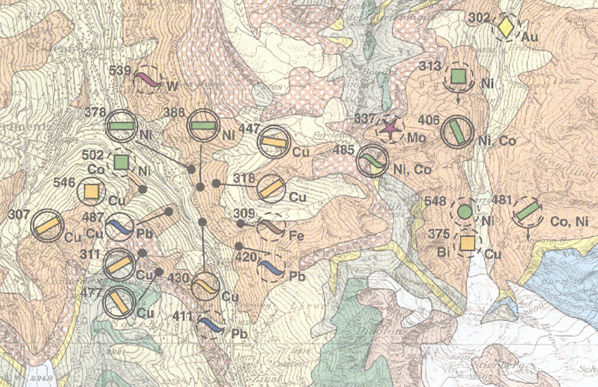
The Lithological-mineralogical map of Switzerland 1:200,000 provides an overview of the subsurface classified according to lithological criteria. The superimposed locations of mineralization, energy raw materials and industrial minerals are classified according to mineralogical criteria and supplemented with details on the type of mineralization, morphology, importance and level of exploitation.
(Original name: Map of Mineral Raw Materials in Switzerland 1:200,000)
Simple
- Alternate title
-
Litho-mineralogical map 200
- Date (Revision)
- 1998-01-01
- Date (Creation)
- 1990-01-01
- Identifier
- ch.swisstopo.geologie-geotechnik-mineralische_rohstoffe200
- Presentation form
- Hardcopy map
- Purpose
-
Übersicht über die Vererzungen der Schweiz
Resource provider
Point of contact
Owner
- Spatial representation type
- paperMap
Spatial resolution
Equivalent scale
- Denominator
- 200000
- Topic category
-
- F Geoscientific information
Extent
Extent
- Description
-
Wallis, Berner-Oberland, Tessin, Uri, Teile Graubündens und des angrenzenden Auslandes
- Geographic identifier
- RK200
))

- Maintenance and update frequency
- Irregular
- Duration of Conservation
- 275
- Appraisal of Archival Value
- A
- Reason for Archiving Value
- Evidence of business practice
- Comment on Archival Value
-
Grundlage ist die Rohstoffdatenbank der Schweiz.
- geocat.ch
-
-
opendata.swiss
-
Conservation and archiving planning AAP - Confederation
-
official geodata
-
- GEMET
-
-
ore
-
mineral
-
raw material
-
- GEMET - INSPIRE themes, version 1.0
-
-
Mineral resources
-
Geology
-
- geocat.ch
-
-
FSDI Federal Spatial Data Infrastructure
-
Associated resource
- Title
-
Geotechnisches Kartenwerk
- Association Type
- Reference to a master resource of which this one is a part
- Language
- Deutsch
- Character encoding
- UTF8
- Subtopic Category
- F1 Geology
- Basic Geodata
- true
- Basic Geodata ID
-
48.4
- Basic Geodata Legal Level
- Federal
- Distribution format
-
-
GeoTIFF (GEOTIFF)
-
Digital transfer options
- OnLine resource
-
Vorschau map.geo.admin.ch
Preview map.geo.admin.ch
Digital transfer options
- OnLine resource
-
ch.swisstopo.geologie-geotechnik-mineralische_rohstoffe200
WMS-FSDI service, layer "Mineral resources 200"
Digital transfer options
- OnLine resource
-
ch.swisstopo.geologie-geotechnik-mineralische_rohstoffe200
WMTS-FSDI service, layer "Mineral resources 200"
Digital transfer options
- OnLine resource
-
Fachgruppe Georessourcen Schweiz
Digital transfer options
- OnLine resource
-
Download (data.geo.admin.ch)
Digital transfer options
- OnLine resource
-
Rohstoffinformationssystem
Digital transfer options
- OnLine resource
-
Geologie-Portal: Geotechnik & Ingenieurgeologie
Digital transfer options
- OnLine resource
-
RESTful API von geo.admin.ch
RESTful API from geo.admin.ch
Digital transfer options
- OnLine resource
-
Permalink opendata.swiss
Permalink opendata.swiss
- Statement
-
Der geologische Untergund wurde auf der Basis des Geologischen Atlas 25'000 kompiliert. Gebiete, in denen dieser bei Erstellung nicht vorhanden war, wurden auf Grund geologischer Spezialkarten und weiterer publizierter Unterlagen ergänzt. Die Daten wurden durch aktuelle, zum Teil unpublizierte Studien ergänzt. Die Auflösung am Boden kann bei abgeleitetet Themenkarten nicht exakt bestimmt werden, da die Lage der geologischen Objekte der Interpretation des kartierenden Geologen unterliegt. Sie weichen zusätzlich durch Gewichtung und Generalisierung vom eigentlichen Ort ab.
- Hierarchy level
- Series
- Reference system identifier
- Referenzsystem entsprechend der zugrundeliegenden topographischen Karte (CH1903)
Metadata
- Metadata identifier
- d86f291c-49b8-4bc8-93f7-dbab48dcb26c
- Language
- Deutsch
- Character encoding
- UTF8
- Language
- Français
- Character encoding
- UTF8
- Language
- Italiano
- Character encoding
- UTF8
- Language
- English
- Character encoding
- UTF8
- Language
- Rumantsch
- Character encoding
- UTF8
Point of contact
Type of resource
- Resource scope
- Dataset
Type of resource
- Resource scope
- Series
- Metadata linkage
-
https://www.geocat.ch/geonetwork/srv/api/records/d86f291c-49b8-4bc8-93f7-dbab48dcb26c
- Date info (Creation)
- 2009-10-13T12:00:00Z
- Date info (Revision)
- 2026-04-13T09:39:24.417728Z
Metadata standard
- Title
-
eCH-0271