geocat.ch
Lithologisch-mineralogische Karte der Schweiz 1:200000
Carte lithologique et minéralogique de la Suisse 1:200000
Carta litologica e mineralogica della Svizzera 1:200000
Lithological and mineralogical map of Switzerland 1:200000
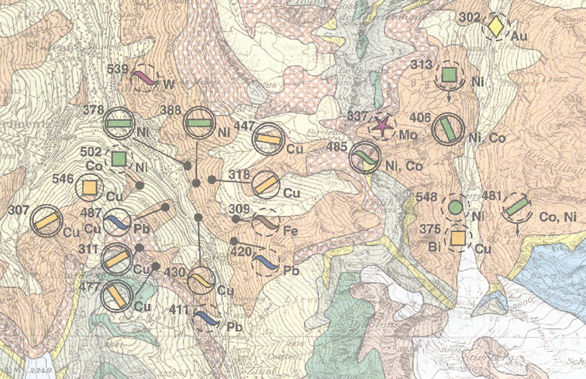
Die lithologisch-mineralogische Karte der Schweiz 1:200'000 liefert eine Übersicht des Untergrundes klassiert nach lithologischen Kriterien. Die überlagerten Fundorte von Vererzungen, Energierohstoffen und Industriemineralen sind nach mineralogischen Kriterien klassiert und mit Angaben zu Mineralisationstyp, Morphologie, Bedeutung und Erschliessungsgrad ergänzt.
(Originalbezeichnung: Karte der mineralischen Rohstoffe der Schweiz 1:200'000)
La carte lithologique et minéralogique de la Suisse 1:200'000 fournit une vue d'ensemble du sous-sol classé selon des critères lithologiques. Les lieux de découverte de minéralisations, de matières premières énergétiques et de minéraux industriels, qui superposent la carte, sont classés selon des critères minéralogiques et complétés par des informations sur le type de minéralisation, morphologie, importance et degré d'exploitation.
(Nom original: Carte des matières premières minérales de la Suisse 1:200'000)
La carta litologica e mineralogica della Svizzera 1:200'000 fornisce una visione d'insieme del sottosuolo classificato secondo criteri litologici. L'ubicazione delle mineralizzazioni, delle risorse energetiche e dei minerali industriali, che si sovrappongono alla carta, sono classificati secondo criteri mineralogici e completati con indicazioni relative al tipo di mineralizzazione, alla morfologia, all'importanza e al grado di sfruttamento.
(Denominazione originale: Carta delle materie prime minerali della Svizzera 1:200'000)
The Lithological-mineralogical map of Switzerland 1:200,000 provides an overview of the subsurface classified according to lithological criteria. The superimposed locations of mineralization, energy raw materials and industrial minerals are classified according to mineralogical criteria and supplemented with details on the type of mineralization, morphology, importance and level of exploitation.
(Original name: Map of Mineral Raw Materials in Switzerland 1:200,000)
Simple
-
Autre titreAltri nomi o acronimiAlternate titleAlternate titleAlternativtitel
-
Litho-mineralogische Karte 200
Carte litho-minéralogique 200
Mappa lito-mineralogica 200
Litho-mineralogical map 200
-
Date (Révision)Data (Revisione)Date (Revision)Date (Revision)Datum (Aktualisierung)
- 1998-01-01
-
Date (Création)Data (Creazione)Date (Creation)Date (Creation)Datum (Erstellung)
- 1990-01-01
-
IdentifiantIdentificatoreIdentifierIdentifierKennung
- ch.swisstopo.geologie-geotechnik-mineralische_rohstoffe200
-
Forme de la présentationForma della presentazionePresentation formPresentation formPräsentationsform
-
Carte papierMappa cartaceaHardcopy mapHardcopy mapPapierkarte
-
ButScopoPurposePurposeZweck
-
Übersicht über die Vererzungen der Schweiz
Vue d'ensemble des gisements de minerai en Suisse
Fournisseur
Fornitore di risorse
Resource provider
Resource provider
Anbieter
Point de contact
Punto di contatto
Point of contact
Point of contact
Ansprechpartner
Propriétaire
Proprietario
Owner
Owner
Eigentümer
-
Type de représentation spatialeTipo di rappresentazione spazialeSpatial representation typeSpatial representation typeRäumliche Darstellungsart
-
paperMappaperMappaperMappaperMappaperMap
Résolution spatiale
Risoluzione spaziale
Spatial resolution
Spatial resolution
Räumliche Auflösung
Fraction représentative
Frazione rappresentativa
Equivalent scale
Equivalent scale
Vergleichsmassstab
-
DénominateurDenominatoreDenominatorDenominatorMassstabszahl
- 200000
-
Catégorie de thèmeCategoria ISOTopic categoryTopic categoryThematik
-
-
F Informations géoscientifiquesF Informazioni geoscientificheF Geoscientific informationF Geoscientific informationF Erdwissenschaften
-
Étendue
Estensione
Extent
Extent
Ausdehnung
Étendue
Estensione
Extent
Extent
Ausdehnung
-
DescriptionDescrizioneDescriptionDescriptionBeschreibung
-
Wallis, Berner-Oberland, Tessin, Uri, Teile Graubündens und des angrenzenden Auslandes
Valais, Oberland bernois, Tessin, Uri, Parties des Grisons et des pays limitrophes
-
Identifiant géographiqueIdentificatore geograficoGeographic identifierGeographic identifierGeografische Kennung
- RK200RK200RK200RK200RK200
))

-
Fréquence de mise à jourFrequenza di aggiornamentoMaintenance and update frequencyMaintenance and update frequencyWartungsintervall
-
IrrégulièreIrregolareIrregularIrregularUnregelmässig
-
Durée de conservationDurata di conservazioneDuration of ConservationDuration of ConservationAufbewahrungsdauer NV in Jahren
- 275
-
Évaluation de la valeur archivistiqueValutazione del valore archivisticoAppraisal of Archival ValueAppraisal of Archival ValueBewertung Archivwürdigkeit
-
AAAAA
-
Raison de la valeur d'archivageMotivo del valore archivisticoReason for Archiving ValueReason for Archiving ValueBegründung Archivwürdigkeit
-
Preuve de la pratique couranteProva della pratica commercialeEvidence of business practiceEvidence of business practiceNachweis der Geschäftspraxis
-
Commentaire sur la valeur d'archivageCommento sul valore di archiviazioneComment on Archival ValueComment on Archival ValueBemerkung zur Archivwürdigkeit
-
Grundlage ist die Rohstoffdatenbank der Schweiz.
- geocat.ch
-
-
opendata.swiss
opendata.swiss
opendata.swiss
opendata.swiss
-
Planification de la conservation et de l'archivage AAP - Conféderation
Pianificazione della conservazione e dell’archiviazione AAP - Confederazione
Conservation and archiving planning AAP - Confederation
-
géodonnées de base
geodati di base
official geodata
-
- GEMET
-
-
minerai
minerale metallifero
ore
-
minéral
minerale
mineral
-
matière première
materia prima
raw material
-
- GEMET - INSPIRE themes, version 1.0
-
-
Ressources minérales
Risorse minerarie
Mineral resources
-
Géologie
Geologia
Geology
-
- geocat.ch
-
-
BGDI Bundesgeodaten-Infrastruktur
IFDG l’Infrastructure Fédérale de données géographiques
IFDG Infrastruttura federale dei dati geografici
FSDI Federal Spatial Data Infrastructure
-
Ressource associée
Risorsa associata
Associated resource
Associated resource
Verlinkte Ressource
-
TitreTitoloTitleTitleTitel
-
Geotechnisches Kartenwerk
Cartes géotechniques
Carte geotecniche
-
Type d'associationTipo di associazioneAssociation TypeAssociation TypeAssoziationstyp
-
Citation de travail plus largeCitazione di un'opera più ampiaReference to a master resource of which this one is a partReference to a master resource of which this one is a partÜbergeordneter Datenbestand
-
LangueLinguaLanguageLanguageSprache
- Deutsch
-
Encodage de caractèresCodifica dei caratteriCharacter encodingCharacter encodingZeichenkodierung
-
Utf8UTF8UTF8UTF8Utf8
-
Catégorie de sous-thèmeCategoria di sottotemaSubtopic CategorySubtopic CategoryThematische Unterkategorien
-
F1 GéologieF1 GeologiaF1 GeologyF1 GeologyF1 Geologie
-
Géodonnées de baseGeodati di baseBasic GeodataBasic GeodataGeobasisdaten
- true
-
Identifiant Géodonnées de baseIdentificativo dei geodati di baseBasic Geodata IDBasic Geodata IDIdentifikator des Geobasisdatensatzes
-
48.4
-
Niveau des géodonnées de baseLivello legale dei geodati di baseBasic Geodata Legal LevelBasic Geodata Legal LevelGeobasisdatenebene
-
FédéralFederaleFederalFederalNational
-
Format de distributionFormato (codifica)Distribution formatDistribution formatAbgabeformat
-
-
GeoTIFF (GEOTIFF)
-
Options de transfert numérique
Opzioni di trasferimento digitale
Digital transfer options
Digital transfer options
Optionen für die digitale Übertragung
-
Ressource en ligneRisorsa onlineOnLine resourceOnLine resourceOnline
-
Vorschau map.geo.admin.ch
Vorschau map.geo.admin.chAperçu map.geo.admin.chPrevisione map.geo.admin.chPreview map.geo.admin.ch
Options de transfert numérique
Opzioni di trasferimento digitale
Digital transfer options
Digital transfer options
Optionen für die digitale Übertragung
-
Ressource en ligneRisorsa onlineOnLine resourceOnLine resourceOnline
-
ch.swisstopo.geologie-geotechnik-mineralische_rohstoffe200
WMS-BGDI Dienst, Layer "Mineralische Rohstoffe 200"Service WMS-IFDG, couche "Mat. premières minérales 200"Servizio WMS-IFDG, strato "Materie prime minerali 200"WMS-FSDI service, layer "Mineral resources 200"WMS-BGDI Dienst, Layer "Mineralische Rohstoffe 200"
Options de transfert numérique
Opzioni di trasferimento digitale
Digital transfer options
Digital transfer options
Optionen für die digitale Übertragung
-
Ressource en ligneRisorsa onlineOnLine resourceOnLine resourceOnline
-
ch.swisstopo.geologie-geotechnik-mineralische_rohstoffe200
WMTS-BGDI Dienst, Layer "Mineralische Rohstoffe 200"Service WMTS-IFDG, couche , Layer "Mat. premières minérales 200"Servizio WMTS-IFDG, strato "Materie prime minerali 200"WMTS-FSDI service, layer "Mineral resources 200"WMTS-BGDI Dienst, Layer "Mineralische Rohstoffe 200"
Options de transfert numérique
Opzioni di trasferimento digitale
Digital transfer options
Digital transfer options
Optionen für die digitale Übertragung
-
Ressource en ligneRisorsa onlineOnLine resourceOnLine resourceOnline
-
Fachgruppe Georessourcen Schweiz
Options de transfert numérique
Opzioni di trasferimento digitale
Digital transfer options
Digital transfer options
Optionen für die digitale Übertragung
-
Ressource en ligneRisorsa onlineOnLine resourceOnLine resourceOnline
-
Download (data.geo.admin.ch)
Options de transfert numérique
Opzioni di trasferimento digitale
Digital transfer options
Digital transfer options
Optionen für die digitale Übertragung
-
Ressource en ligneRisorsa onlineOnLine resourceOnLine resourceOnline
-
Rohstoffinformationssystem
Options de transfert numérique
Opzioni di trasferimento digitale
Digital transfer options
Digital transfer options
Optionen für die digitale Übertragung
-
Ressource en ligneRisorsa onlineOnLine resourceOnLine resourceOnline
-
Geologie-Portal: Geotechnik & Ingenieurgeologie
Options de transfert numérique
Opzioni di trasferimento digitale
Digital transfer options
Digital transfer options
Optionen für die digitale Übertragung
-
Ressource en ligneRisorsa onlineOnLine resourceOnLine resourceOnline
-
RESTful API von geo.admin.ch
RESTful API von geo.admin.chRESTful API de geo.admin.chRESTful API da geo.admin.chRESTful API from geo.admin.chRESTful API dad geo.admin.ch
Options de transfert numérique
Opzioni di trasferimento digitale
Digital transfer options
Digital transfer options
Optionen für die digitale Übertragung
-
Ressource en ligneRisorsa onlineOnLine resourceOnLine resourceOnline
-
Permalink opendata.swiss
Permalink opendata.swissPermalink opendata.swissPermalink opendata.swissPermalink opendata.swiss
-
Généralités sur la provenanceInformazioni generali sulla provenienzaStatementStatementErklärung
-
Der geologische Untergund wurde auf der Basis des Geologischen Atlas 25'000 kompiliert. Gebiete, in denen dieser bei Erstellung nicht vorhanden war, wurden auf Grund geologischer Spezialkarten und weiterer publizierter Unterlagen ergänzt. Die Daten wurden durch aktuelle, zum Teil unpublizierte Studien ergänzt. Die Auflösung am Boden kann bei abgeleitetet Themenkarten nicht exakt bestimmt werden, da die Lage der geologischen Objekte der Interpretation des kartierenden Geologen unterliegt. Sie weichen zusätzlich durch Gewichtung und Generalisierung vom eigentlichen Ort ab.
-
NiveauLivelloHierarchy levelHierarchy levelBezugsebene
-
SérieSerieSeriesSeriesSerie
-
Nom du système de référenceNome del sistema di riferimentoReference system identifierReference system identifierName des Referenzsystems
- Referenzsystem entsprechend der zugrundeliegenden topographischen Karte (CH1903)
Metadata
-
Identifiant des métadonnéesIdentificativo della schedaMetadata identifierMetadata identifierIdentifikator des Metadatensatzes
- d86f291c-49b8-4bc8-93f7-dbab48dcb26c
-
LangueLinguaLanguageLanguageSprache
- Deutsch
-
Encodage de caractèresCodifica dei caratteriCharacter encodingCharacter encodingZeichenkodierung
-
Utf8UTF8UTF8UTF8Utf8
-
LangueLinguaLanguageLanguageSprache
- Français
-
Encodage de caractèresCodifica dei caratteriCharacter encodingCharacter encodingZeichenkodierung
-
Utf8UTF8UTF8UTF8Utf8
-
LangueLinguaLanguageLanguageSprache
- Italiano
-
Encodage de caractèresCodifica dei caratteriCharacter encodingCharacter encodingZeichenkodierung
-
Utf8UTF8UTF8UTF8Utf8
-
LangueLinguaLanguageLanguageSprache
- English
-
Encodage de caractèresCodifica dei caratteriCharacter encodingCharacter encodingZeichenkodierung
-
Utf8UTF8UTF8UTF8Utf8
-
LangueLinguaLanguageLanguageSprache
- Rumantsch
-
Encodage de caractèresCodifica dei caratteriCharacter encodingCharacter encodingZeichenkodierung
-
Utf8UTF8UTF8UTF8Utf8
Point de contact
Punto di contatto
Point of contact
Point of contact
Ansprechpartner
Type de ressource
Tipo di risorsa
Type of resource
Type of resource
Anwendungsbereich der Metadaten
-
Domaine d'application de la ressourceAmbito di applicazione della risorsaResource scopeResource scopeDomäne der Ressourcenanwendung
-
Jeu de donnéesSet di datiDatasetDatasetDatenbestand
Type de ressource
Tipo di risorsa
Type of resource
Type of resource
Anwendungsbereich der Metadaten
-
Domaine d'application de la ressourceAmbito di applicazione della risorsaResource scopeResource scopeDomäne der Ressourcenanwendung
-
SérieSerieSeriesSeriesSerie
-
Lien vers la métadonnéeCollegamento ai metadatiMetadata linkageMetadata linkageLink zu den Metadaten
-
Informations de date (Création)Informazioni sulla data (Creazione)Date info (Creation)Date info (Creation)Datumsangaben (Erstellung)
- 2009-10-13T12:00:00Z
-
Informations de date (Révision)Informazioni sulla data (Revisione)Date info (Revision)Date info (Revision)Datumsangaben (Aktualisierung)
- 2026-04-13T09:39:24.417728Z
Norme des métadonnées
Standard dei metadati
Metadata standard
Metadata standard
Metadatenstandard
-
TitreTitoloTitleTitleTitel
-
eCH-0271