geocat.ch
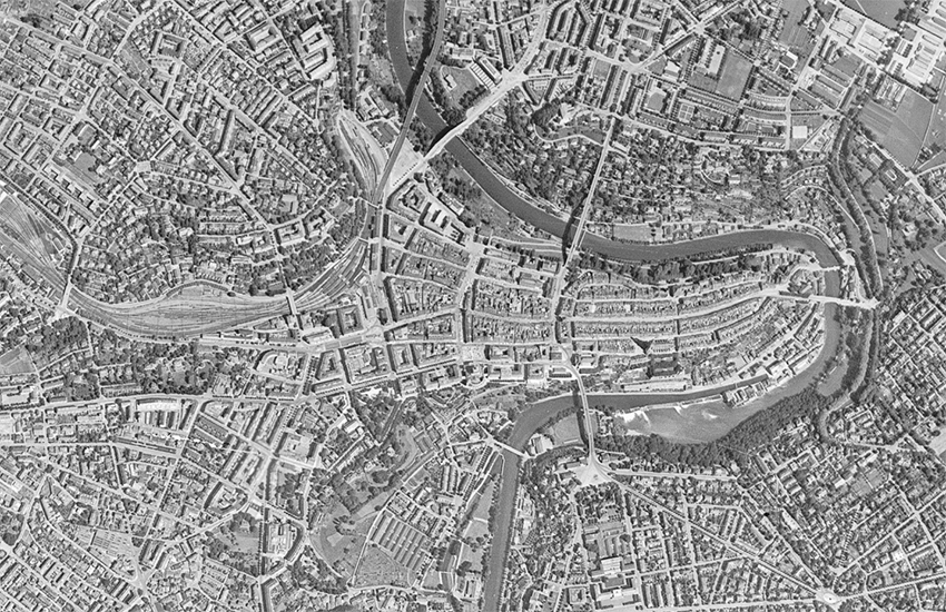
SWISSIMAGE HIST 1946: Das Orthophotomosaik der Schweiz von 1946
Das Orthofotomosaik SWISSIMAGE HIST 1946 ist eine Zusammensetzung von historischen Schwarz-Weiss-Luftbildern von 1946 («Amerikanerbefliegung») über die ganze Schweiz mit einer Bodenauflösung von 1 m. Ein Orthofoto ist ein Luftbild bei dem Neigungseinflüsse der Kamera und des Geländes korrigiert wurden.
Einfach
- Alternativtitel
-
SWISSIMAGE HIST 1946
- Datum (Erstellung)
- 2019-03-01
- Kennung
- ch.swisstopo.swissimage-product_1946
Eigentümer
Räumliche Auflösung
- Distanz
- 1 m
- Thematik
-
- A Oberflächenbeschreibung
Ausdehnung
Ausdehnung
- Beschreibung
-
swissimage hist 1946
- Geografische Kennung
- swissimage hist 1946
))

- Wartungsintervall
- Unbekannt
- geocat.ch
-
-
Historische Karte
-
Rasterdaten
-
opendata.swiss
-
Orthofoto
-
- GEMET
-
-
Mosaik
-
Luftbild
-
Luftbild
-
- GEMET - INSPIRE themes, version 1.0
-
-
Orthofotografie
-
- geocat.ch
-
-
BGDI Bundesgeodaten-Infrastruktur
-
Ressourcenbeschränkungen
- Andere Einschränkungen
-
Freie Nutzung. Quellenangabe ist Pflicht.
Verlinkte Ressource
- Titel
-
Orthofotos (Landesvermessung)
- Assoziationstyp
- Übergeordneter Datenbestand
- Sprache
- Deutsch
- Zeichenkodierung
- Utf8
- Thematische Unterkategorien
- A3 Luft-, Satellitenbilder
- Geobasisdaten
- true
- Identifikator des Geobasisdatensatzes
-
35
- Geobasisdatenebene
- National
- Geobasisdatentyp
- Georeferenzdaten
- Abgabeformat
-
-
Tagged Image File Format (TIFF)
-
Optionen für die digitale Übertragung
- Online
-
Vorschau map.geo.admin.ch
Vorschau map.geo.admin.ch
Optionen für die digitale Übertragung
- Online
-
ch.swisstopo.swissimage-product_1946
WMS-BGDI Dienst, Layer "SWISSIMAGE HIST 1946"
Optionen für die digitale Übertragung
- Online
-
ch.swisstopo.swissimage-product_1946
WMTS-BGDI Dienst, Layer "SWISSIMAGE HIST 1946"
Optionen für die digitale Übertragung
- Online
-
SWISSIMAGE HIST 1946
- Name des Referenzsystems
- EPSG:21781
Metadaten
- Identifikator des Metadatensatzes
- d86ba57c-6053-44bf-9516-2ea3d376d76d
- Sprache
- Deutsch
- Zeichenkodierung
- Utf8
- Sprache
- Français
- Zeichenkodierung
- Utf8
- Sprache
- Italiano
- Zeichenkodierung
- Utf8
- Sprache
- English
- Zeichenkodierung
- Utf8
- Sprache
- Rumantsch
- Zeichenkodierung
- Utf8
Ansprechpartner
Anwendungsbereich der Metadaten
- Domäne der Ressourcenanwendung
- Datenbestand
- Link zu den Metadaten
-
https://www.geocat.ch/geonetwork/srv/api/records/d86ba57c-6053-44bf-9516-2ea3d376d76d
- Datumsangaben (Erstellung)
- 2019-02-26T15:03:27Z
- Datumsangaben (Aktualisierung)
- 2026-04-13T09:41:52.513397Z
Metadatenstandard
- Titel
-
eCH-0271