geocat.ch
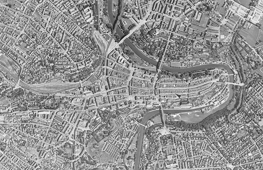
SWISSIMAGE HIST 1946: The Orthophotomosaic of Switzerland from 1946
The orthophoto mosaic SWISSIMAGE HIST 1946 is a composition of historical black and white aerial photographs from 1946 («US flight mission») over the whole of Switzerland with a ground resolution of 1 m. An orthophoto is an aerial image in which the distortions created by the camera and the relief are corrected.
Simple
- Alternate title
-
SWISSIMAGE HIST 1946
- Date (Creation)
- 2019-03-01
- Identifier
- ch.swisstopo.swissimage-product_1946
Owner
Spatial resolution
- Spatial resolution
- 1 m
- Topic category
-
- A Imagery base maps earth cover
Extent
Extent
- Description
-
swissimage hist 1946
- Geographic identifier
- swissimage hist 1946
))

- Maintenance and update frequency
- Unknown
- geocat.ch
-
-
historic map
-
raster data
-
opendata.swiss
-
orthophoto
-
- GEMET
-
-
mosaic
-
aerial photograph
-
aerial photograph
-
- GEMET - INSPIRE themes, version 1.0
-
-
Orthoimagery
-
- geocat.ch
-
-
FSDI Federal Spatial Data Infrastructure
-
Resource constraints
- Other constraints
-
NonCommercialAllowed-CommercialAllowed-ReferenceRequired
Associated resource
- Title
-
Orthofotos (Landesvermessung)
- Association Type
- Reference to a master resource of which this one is a part
- Language
- Deutsch
- Character encoding
- UTF8
- Subtopic Category
- A3 Aerial and Satellite Imagery
- Basic Geodata
- true
- Basic Geodata ID
-
35
- Basic Geodata Legal Level
- Federal
- Basic Geodata Type
- Reference Geodata
- Distribution format
-
-
Tagged Image File Format (TIFF)
-
Digital transfer options
- OnLine resource
-
Vorschau map.geo.admin.ch
Preview map.geo.admin.ch
Digital transfer options
- OnLine resource
-
ch.swisstopo.swissimage-product_1946
WMS-FSDI service, layer "SWISSIMAGE HIST 1946"
Digital transfer options
- OnLine resource
-
ch.swisstopo.swissimage-product_1946
WMTS-FSDI service, layer "SWISSIMAGE HIST 1946"
Digital transfer options
- OnLine resource
-
SWISSIMAGE HIST 1946
- Reference system identifier
- EPSG:21781
Metadata
- Metadata identifier
- d86ba57c-6053-44bf-9516-2ea3d376d76d
- Language
- Deutsch
- Character encoding
- UTF8
- Language
- Français
- Character encoding
- UTF8
- Language
- Italiano
- Character encoding
- UTF8
- Language
- English
- Character encoding
- UTF8
- Language
- Rumantsch
- Character encoding
- UTF8
Point of contact
Type of resource
- Resource scope
- Dataset
- Metadata linkage
-
https://www.geocat.ch/geonetwork/srv/api/records/d86ba57c-6053-44bf-9516-2ea3d376d76d
- Date info (Creation)
- 2019-02-26T15:03:27Z
- Date info (Revision)
- 2026-04-13T09:41:52.513397Z
Metadata standard
- Title
-
eCH-0271