geocat.ch
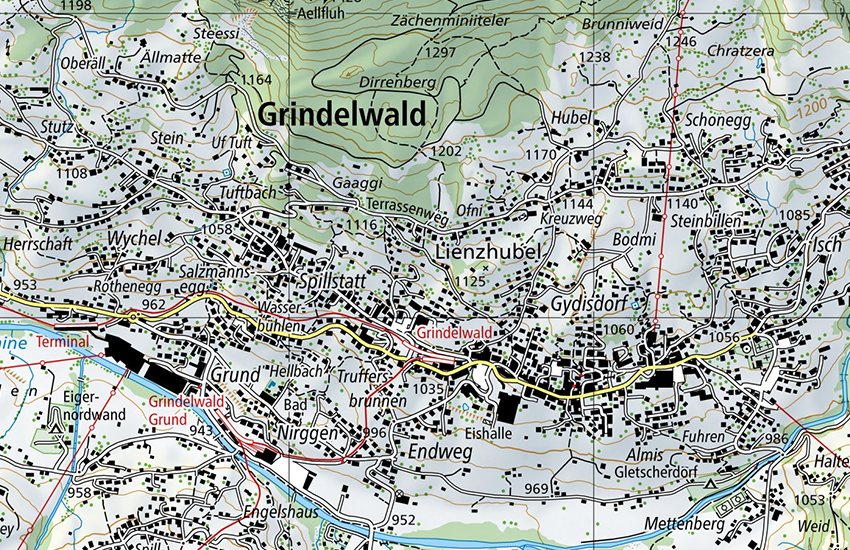
Swiss Map Vector 25, Swiss national vector map 1:25 000
Swiss Map Vector 25 is the Swiss national 1:25,000 scale map in vector format. It includes all complete and differentiated rail, road and path networks, a detailed representation of residential areas, bodies of water, vegetation and terrains complete with annotations. Raster data for relief and rock features complete the vector data. Vector data comes from the digital cartographic model, which is also used for the derivation of printed maps, and the Swiss Map Raster. Contents are structured according to subject matter and can be edited by class or by object. Depiction is very similar to that of the printed national map.
Simple
- Alternate title
-
Swiss Map Vector 25
- Date (Creation)
- 2016-10-01
- Date (Revision)
- 2025-12-04
- Identifier
- ch.swisstopo.swiss-map-vector25
- Presentation form
- Digital map
- Purpose
-
Georeferenzdaten des Bundesrechts
- Status
- On going
Point of contact
Owner
- Spatial representation type
- paperMap
- Spatial representation type
- Vector
Spatial resolution
Equivalent scale
- Denominator
- 25000
- Topic category
-
- A Imagery base maps earth cover
Extent
Extent
- Description
-
Switzerland
))

Extent
Extent
- Description
-
Liechtenstein
))

- Maintenance and update frequency
- Unknown
- GEMET
-
-
vector
-
relief (land)
-
border
-
cartography
-
water (geographic)
-
vegetation
-
- geocat.ch
-
-
GIS (Geographic Information System)
-
traffic network
-
national map
-
opendata.swiss
-
terrain representation
-
FSDI Federal Spatial Data Infrastructure
-
- geocat.ch
-
-
topography
-
- GEMET
-
-
map chart
-
Resource constraints
- Other constraints
- Opendata BY: Open use. Must provide the source.
Associated resource
- Association Type
- Reference to a master resource of which this one is a part
- Metadata Reference
Associated resource
- Title
-
National Maps 1:25'000 au 1:1'000'000
- Association Type
- Reference to a master resource of which this one is a part
- Language
- Deutsch
- Character encoding
- UTF8
- Language
- Français
- Character encoding
- UTF8
- Language
- Italiano
- Character encoding
- UTF8
- Language
- Rumantsch
- Character encoding
- UTF8
- Subtopic Category
- A1 Base Maps, Landscape Models
- Basic Geodata
- true
- Basic Geodata ID
-
42.7
- Basic Geodata Legal Level
- Federal
- Distribution format
-
-
ESRI File Geodatabase FileGDB (GDB)
-
OGC Geopackage (GPKG)
-
Distributor
Digital transfer options
Digital transfer options
- OnLine resource
-
geo.admin.ch: das Geoportal des Bundes
- Statement
-
Based on the topographic survey
- Hierarchy level
- Dataset
- Reference system identifier
- CH1903+
Metadata
- Metadata identifier
- d6b542d7-7e9a-42c9-82fa-b434db54bb72
- Language
- Deutsch
- Character encoding
- UTF8
- Language
- Français
- Character encoding
- UTF8
- Language
- Italiano
- Character encoding
- UTF8
- Language
- English
- Character encoding
- UTF8
- Language
- Rumantsch
- Character encoding
- UTF8
Point of contact
Type of resource
- Resource scope
- Dataset
- Metadata linkage
-
https://www.geocat.ch/geonetwork/srv/api/records/d6b542d7-7e9a-42c9-82fa-b434db54bb72
- Date info (Creation)
- 2020-12-16T10:28:27Z
- Date info (Revision)
- 2026-04-13T09:37:59.335446Z
Metadata standard
- Title
-
GM03 2+