geocat.ch
Bacini d’impiego et grande bacini d'impiego
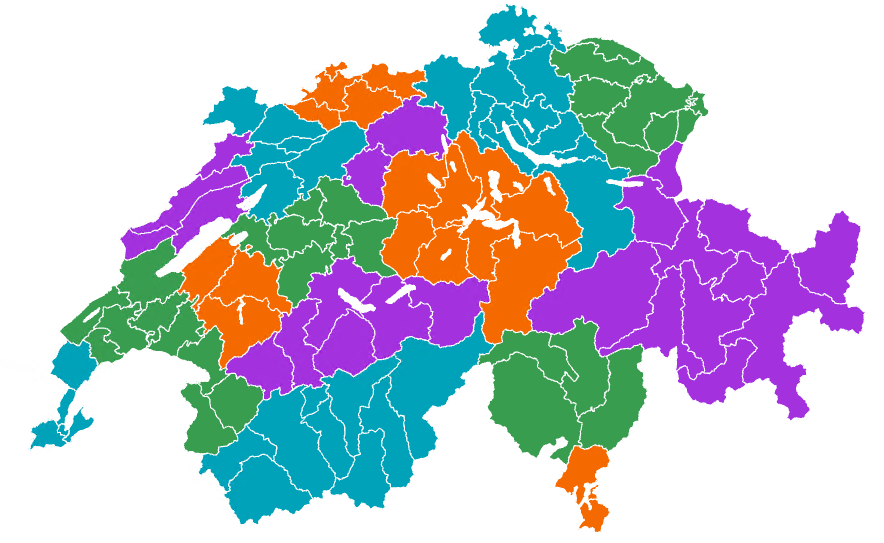
Arbeitsmarktregionen und Arbeitsmarktgrossregionen sind Gebiete, in denen die Mehrheit der Erwerbstätigen wohnt und arbeitet. Die beiden Räume unterscheiden sich in ihrer Grösse: Arbeitsmarktregionen sind relativ klein, Arbeitsmarktgrossregionen deutlich grösser. Diese und viele weitere räumliche Gliederungen wie Sprachregionen, Berggebiete oder Grossregionen werden in zwei Generalisierungsstufen angeboten. Die Vektordaten eignen sich zur Erstellung thematischer Karten und zur Analyse regionaler Entwicklungen und Trends im Zeitverlauf.
Semplice
- Altri nomi o acronimi
-
Bacini d’impiego et grande bacini d'impiego
- Data (Pubblicazione)
- 2025-07-02
- Identificatore
- ch.bfs.arbeitsmarktregionen
- Stato
- In corso
Punto di contatto
- Categoria ISO
-
- D Confini
Estensione
Estensione
- Descrizione
-
Svizzera
))

- Frequenza di aggiornamento
- Annualmente
- Durata di conservazione
- 100
- Valutazione del valore archivistico
- A
Formato della risorsa
- Titolo
-
OGC Geopackage (GPKG)
- Data
Formato della risorsa
- Titolo
-
ESRI Shapefile (SHP)
- Data
Formato della risorsa
- Titolo
-
GeoJSON (GEOJSON)
- Data
- Parole chiave
-
-
livelli geografici
-
- Art des Geodatendienstes
-
-
Servizio di scaricamento
-
- geocat.ch
-
-
linea di confine
-
opendata.swiss
-
IFDG Infrastruttura federale dei dati geografici
-
Utilizzo specifico della risorsa
- Utilizzo
-
Die Vektordaten eignen sich zur Erstellung thematischer Karten und zur Analyse regionaler Entwicklungen und Trends im Zeitverlauf.
Vincoli sulle risorse
- Vincoli d'uso
- Altre restrizioni
- Lingua
- Deutsch
- Codifica dei caratteri
- UTF8
- Geodati di base
- false
- Livello legale dei geodati di base
- Federale
- Formato (codifica)
-
-
OGC Geopackage (GPKG)
-
ESRI Shapefile (SHP)
-
GeoJSON (GEOJSON)
-
Opzioni di trasferimento digitale
- Risorsa online
-
Datenbeschreibung
Opzioni di trasferimento digitale
- Risorsa online
-
GEOSTAT
GEOSTAT ist das BFS-Kompetenzzentrum für Geoinformation und digitale Bildverarbeitung.
Opzioni di trasferimento digitale
- Risorsa online
-
Visualisierung und Download
Opzioni di trasferimento digitale
- Risorsa online
-
ch.bfs.arbeitsmarktregionen
Servizio WMS-IFDG, strato "Bacini d`impiego et grande bacini d`impiego"
Opzioni di trasferimento digitale
- Risorsa online
-
ch.bfs.arbeitsmarktregionen
Servizio WMTS-IFDG, strato "Bacini d'impiego et grande bacini d'impiego"
Opzioni di trasferimento digitale
- Risorsa online
-
RESTful API von geo.admin.ch
Opzioni di trasferimento digitale
- Risorsa online
-
Vorschau map.geo.admin.ch
Opzioni di trasferimento digitale
- Risorsa online
-
Variablenliste
I14Y Piattaforma di interoperabilità
- Nome del sistema di riferimento
- EPSG: 2056
Metadati
- Identificativo della scheda
- d4ecc043-a230-4b74-a725-7f63fa2a0419
- Lingua
- Deutsch
- Codifica dei caratteri
- UTF8
- Lingua
- Français
- Codifica dei caratteri
- UTF8
- Lingua
- Italiano
- Codifica dei caratteri
- UTF8
- Lingua
- English
- Codifica dei caratteri
- UTF8
- Lingua
- Rumantsch
- Codifica dei caratteri
- UTF8
Custode
- Collegamento ai metadati
-
https://www.geocat.ch/geonetwork/srv/api/records/d4ecc043-a230-4b74-a725-7f63fa2a0419
- Informazioni sulla data (Creazione)
- 2025-04-14T13:43:42.07Z
- Informazioni sulla data (Revisione)
- 2026-06-15T08:46:04.319778Z
Standard dei metadati
- Titolo
-
eCH-0271