geocat.ch
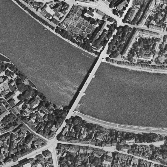
Orthofoto 1926
Entzerrte und georeferenzierte digitale Luftbilder von 1926 in TrueColor.
Vom 1. Juli – 15. September 1926 fand in den soeben neu erstellten Messehallen eine internationale Ausstellung zum Thema „Binnenschifffahrt und Wasserbau“ statt. Sie wurde aus Anlass der Fertigstellung der Kleinhüninger Hafenanlagen durchgeführt. Ein Ziel dieser Veranstaltung war auch die Schiffbarmachung des Hochrheins vorantreiben. Dazu wurde ein 28 x 7 Meter grosses Fliegerbild hergestellt und in der Ausstellung präsentiert, welches das Gebiet des Rheins von Basel bis zum Bodensee abdeckte. Ein Teil dieser rund 520 Negative aus dem Bestand des Staatsarchivs Basel-Stadt wurde nun digitalisiert und zu einem Orthofoto zusammengesetzt.
Quelle: Staatsarchiv Basel-Stadt, NEG Rheinflug A 4676 bis und mit NEG Rheinflug A 5106
Semplice
- Data (Creazione)
- 1926-01-01
- Stato
- Completato
Proprietario
- Tipo di rappresentazione spaziale
- Raster
Risoluzione spaziale
- Distanza di risoluzione
- 0.2 m
Risoluzione spaziale
- Distanza di risoluzione
- 0.4 m
- Categoria ISO
-
- A Mappe di base con immagini della copertura terrestre
Estensione
Estensione
- Descrizione
-
Orthofoto 1999
- Identificatore geografico
- Orthofoto 1999
))

- Frequenza di aggiornamento
- Non pianificato
- GEMET - INSPIRE themes, version 1.0
-
-
Orto immagini
-
- GEMET
-
-
fotografia aerea (immagine)
-
- GEMET
-
-
fotografia aerea (procedimento)
-
- geocat.ch
-
-
opendata.swiss
-
Vincoli sulle risorse
- Altri vincoli
-
Die Geodaten sind öffentlich zugänglich. (Zugangsberechtigungsstufe [A] = öffentlich)
- Altri vincoli
-
Es gelten die Nutzungsbedingungen für Geodaten des Kantons Basel-Stadt. ( http://www.geo.bs.ch/agb)
Risorsa associata
- Tipo di associazione
- È una descrizione di
- Riferimento metadati
Risorsa associata
- Titolo
-
Orthofotos
- Tipo di associazione
- Citazione di un'opera più ampia
- Lingua
- Deutsch
- Codifica dei caratteri
- UTF8
- Categoria di sottotema
- A1 Mappe di base, modelli paesaggistici
- Categoria di sottotema
- A3 Immagini aeree e satellitari
- Geodati di base
- true
- Identificativo dei geodati di base
-
10
- Livello legale dei geodati di base
- Cantonal
- Tipo di geodati di base
- openData
- Formato (codifica)
-
-
Tagged Image File Format (TIFF)
-
JPEG (JPG)
-
Distributore
- Orario di servizio
-
Mo - Do: 8:00 bis 12:00, 13:30 bis 16:30, Fr: 8:00 bis 12:00, 13:30 bis 16:00
Opzioni di trasferimento digitale
- Risorsa online
-
MapBS
Öffentliches Auskunftssystem des Kantons Basel-Stadt
Opzioni di trasferimento digitale
- Risorsa online
-
Geodaten-Shop
Öffentlich zugänglicher Geodaten-Downloaddienst des Kantons Basel-Stadt
Opzioni di trasferimento digitale
- Risorsa online
-
WMS BS
Die derzeit im WMS BS verfügbaren Datenebenen entsprechen, bis auf wenige Ausnahmen, den Geodaten, welche auch in MapBS dargestellt sind. Der WMS BS ist kostenlos nutzbar und bietet Zugriff auf öffentliche sowie beschränkt öffentliche Geodaten, wobei gegebenenfalls Benutzername und Passwort benötigt werden (Zugangsdaten von MapBS).
Opzioni di trasferimento digitale
- Risorsa online
-
Permalink opendata.swiss
Permalink opendata.swiss
- Nome del sistema di riferimento
- CH1903+ / LV95/EPSG: 2056
Metadati
- Identificativo della scheda
- d41788d3-bd8d-49d2-bc92-c209620e5a0c
- Lingua
- Deutsch
- Codifica dei caratteri
- UTF8
- Lingua
- Français
- Codifica dei caratteri
- UTF8
- Lingua
- Italiano
- Codifica dei caratteri
- UTF8
- Lingua
- English
- Codifica dei caratteri
- UTF8
Custode
Tipo di risorsa
- Ambito di applicazione della risorsa
- Set di dati
- Collegamento ai metadati
-
https://www.geocat.ch/geonetwork/srv/api/records/d41788d3-bd8d-49d2-bc92-c209620e5a0c
- Informazioni sulla data (Creazione)
- 2022-06-16T13:29:26Z
- Informazioni sulla data (Revisione)
- 2026-04-13T09:47:52.590511Z
Standard dei metadati
- Titolo
-
eCH-0271