geocat.ch
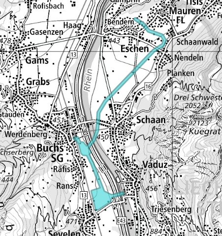
UAS Awareness Zones Switzerland
The UAS Awareness Map indicates areas of authorised unmanned aircraft (UAS) operations.
The purpose of the publication of such areas is to enhance situational awareness for manned aviation and provide relevant contact information.
Consulting this information from the UAS Awareness Map doesn’t change the safety of your flight and is not a requirement.
<br></br>
The UAS Awareness Map depicts selected UAS operations only, in particular permanent or regularly recurring operations and activities in locally identified hotspot areas, which do not qualify for official aeronautical information publication.
<br></br>
Important note:
<ul>
<li>UAS operator/remote pilot remain fully responsible for airspace monitoring and for ensuring separation from manned aircraft. [UAS.SPEC.060 (3) ANNEX TO IMPLEMENTING REGULATION (EU) 2019/947 / SERA.3201] </li>
<li>The displayed areas are for situational awareness only.</li>
<li>The operational volumes shown correspond to operations approved under the Specific Category, with procedures established and validated according to the assessed local risk level and in compliance with the regulation (EU)2019/947.</li>
</ul>
For questions or coordination requests, please contact the respective operator. Contact details are available in the zones information panel.
Simple
- Alternate title
-
UAS Awareness Zones
- Date (Creation)
- 2026-02-04T00:00:00
- Date (Publication)
- 2026-06-21T02:00:29.8658586
- Identifier
- ch.bazl.uas-aktivitaetszonen
- Status
- On going
Point of contact
Spatial resolution
Equivalent scale
- Denominator
- 5000
Spatial resolution
Equivalent scale
- Denominator
- 1000000
- Topic category
-
- P Transportation
Extent
Extent
- Description
-
Switzerland
))

Extent
Extent
- Description
-
Liechtenstein
))

- Maintenance and update frequency
- Unknown
Resource format
- Title
-
OGC Geopackage (GPKG)
- Date
- geocat.ch
-
-
opendata.swiss
-
airspace
-
air navigation
-
- GEMET
-
-
aircraft
-
- geocat.ch
-
-
FSDI Federal Spatial Data Infrastructure
-
Resource constraints
- Use constraints
- Other restrictions
- Other constraints
- Opendata BY: Open use. Must provide the source.
- Other constraints
- Language
- Deutsch
- Character encoding
- UTF8
- Language
- Français
- Character encoding
- UTF8
- Language
- Italiano
- Character encoding
- UTF8
- Language
- English
- Character encoding
- UTF8
- Distribution format
-
-
OGC Geopackage (GPKG)
-
Digital transfer options
- OnLine resource
-
Vorschau map.geo.admin.ch
Preview map.geo.admin.ch
Digital transfer options
- OnLine resource
-
ch.bazl.uas-aktivitaetszonen
WMS-FSDI service, layer "UAS Awareness Zones Switzerland"
Digital transfer options
- OnLine resource
-
ch.bazl.uas-aktivitaetszonen
WMTS-FSDI service, layer "UAS Awareness Zones Switzerland"
Digital transfer options
Digital transfer options
Digital transfer options
- OnLine resource
-
RESTful API von geo.admin.ch
RESTful API from geo.admin.ch
Digital transfer options
- Geometric object type
- Surface
- Reference system identifier
- EPSG:2056
Metadata
- Metadata identifier
- d3528da5-c074-4ff6-bc70-53ab7983d46d
- Language
- Deutsch
- Character encoding
- UTF8
- Language
- Français
- Character encoding
- UTF8
- Language
- Italiano
- Character encoding
- UTF8
- Language
- English
- Character encoding
- UTF8
- Language
- Rumantsch
- Character encoding
- UTF8
Point of contact
Type of resource
- Resource scope
- Dataset
- Metadata linkage
-
https://www.geocat.ch/geonetwork/srv/api/records/d3528da5-c074-4ff6-bc70-53ab7983d46d
- Date info (Creation)
- 2025-11-05T16:59:21.671Z
- Date info (Revision)
- 2026-06-21T00:00:30.095211Z
Metadata standard
- Title
-
eCH-0271