geocat.ch
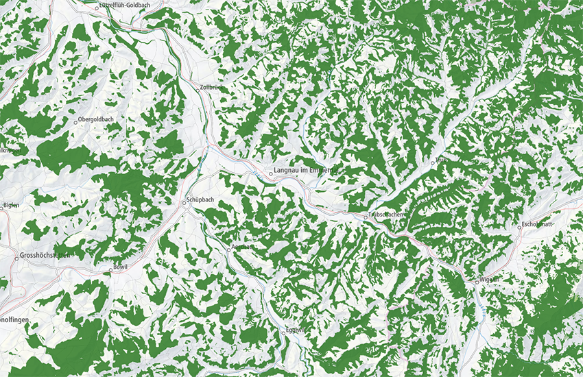
swissTLM3D Forest
swissTLM3D Forest contains the forested areas of Switzerland and the Principality of Liechtenstein. It is part of the dataset swissTLM3D. With a high accuracy and the incorporation of a third dimension, swissTLM3D is the most extensive 3D vector data set of Switzerland. In swissTLM3D Forest, the object types "Forest", "Sparse forest" and "Bush forest" are represented differently.
Simple
- Alternate title
-
Forest swissTLM3D
- Date (Creation)
- 2020-03-18
- Date (Revision)
- 2026-02-24
- Edition
-
Version 2.4
- Edition date
- 2026-02-24T00:00:00
- Identifier
- ch.swisstopo.swisstlm3d-wald
- Status
- On going
Point of contact
Owner
- Spatial representation type
- Vector
Spatial resolution
Equivalent scale
- Denominator
- 5000
Spatial resolution
Equivalent scale
- Denominator
- 25000
- Topic category
-
- A Imagery base maps earth cover
Extent
Extent
- Description
-
Switzerland
))

Extent
Extent
- Description
-
Liechtenstein
))

- Maintenance and update frequency
- Annually
- Maintenance note
-
The existing data was migrated into the TLM as a basis. The data is now updated based on an update cycle of 3 years and improvements and additions are made to the geometries and attributes. Parallel to the three-year update process, an annual update is carried out through the integration of data from so-called reference partners for selected topics. Initially, this annual update is implemented mainly for the administrative boundaries and road links. The official cadastral survey plays an important role as a reference partner in this process. The nomenclature for updating names are also integrated from the official cadastral survey.
- Duration of Conservation
- 275
- Appraisal of Archival Value
- A
- Reason for Archiving Value
- Evidence of business practice
- geocat.ch
-
-
wooded area
-
landscape model
-
opendata.swiss
-
GIS (Geographic Information System)
-
Conservation and archiving planning AAP - Confederation
-
land cover
-
official geodata
-
- GEMET
-
-
wood
-
geographic information system
-
vector
-
- GEMET - INSPIRE themes, version 1.0
-
-
Geographical names
-
Land cover
-
- geocat.ch
-
-
FSDI Federal Spatial Data Infrastructure
-
Resource constraints
- Use constraints
- Other restrictions
- Other constraints
-
NonCommercialAllowed-CommercialAllowed-ReferenceRequired
Associated resource
- Association Type
- Reference to a master resource of which this one is a part
- Metadata Reference
Associated resource
- Title
-
topographical landscape model (national survey)
- Association Type
- Reference to a master resource of which this one is a part
- Language
- Deutsch
- Character encoding
- UTF8
- Subtopic Category
- A1 Base Maps, Landscape Models
- Basic Geodata
- true
- Basic Geodata ID
-
38.1
- Basic Geodata Legal Level
- Federal
- Basic Geodata Type
- Reference Geodata
- Included with dataset
- false
- Title
-
Objektkatalog swissTLM3D 2.4
- Date (Revision)
- 2026-02-24
- Distribution format
-
-
ESRI File Geodatabase FileGDB (GDB)
-
ESRI Shapefile (SHP)
-
AutoCAD DXF (DXF)
-
INTERLIS 2 (XTF)
-
OGC Geopackage (GPKG)
-
Digital transfer options
- OnLine resource
-
Vorschau map.geo.admin.ch
Preview map.geo.admin.ch
Digital transfer options
- OnLine resource
-
ch.swisstopo.swisstlm3d-wald
WMS-FSDI service, layer "Forest swissTLM3D"
Digital transfer options
- OnLine resource
-
ch.swisstopo.swisstlm3d-wald
WMTS-FSDI service, layer "Forest swissTLM3D"
Digital transfer options
- Statement
-
Geometric accuracy of swissTLM3D: 0.2 -1.5 m in all three dimensions for well-defined landscape features such as roads and buildings; 1 - 3 m in all three dimensions for landscape features which are not clearly defined such as forests)
- Hierarchy level
- Dataset
- Reference system identifier
- EPSG:2056
- Reference system identifier
- EPSG:5728
Metadata
- Metadata identifier
- cdb289d5-db16-4440-8529-5807a262f6a2
- Language
- Deutsch
- Character encoding
- UTF8
- Language
- Français
- Character encoding
- UTF8
- Language
- Italiano
- Character encoding
- UTF8
- Language
- English
- Character encoding
- UTF8
- Language
- Rumantsch
- Character encoding
- UTF8
Point of contact
Type of resource
- Resource scope
- Dataset
- Metadata linkage
-
https://www.geocat.ch/geonetwork/srv/api/records/cdb289d5-db16-4440-8529-5807a262f6a2
- Date info (Creation)
- 2020-04-22T11:46:04Z
- Date info (Revision)
- 2026-05-27T10:16:44.281184Z
Metadata standard
- Title
-
eCH-0271