geocat.ch
swissTLM3D Wald
swissTLM3D Forêt
swissTLM3D Foresta
swissTLM3D Forest
swissTLM3D guaud
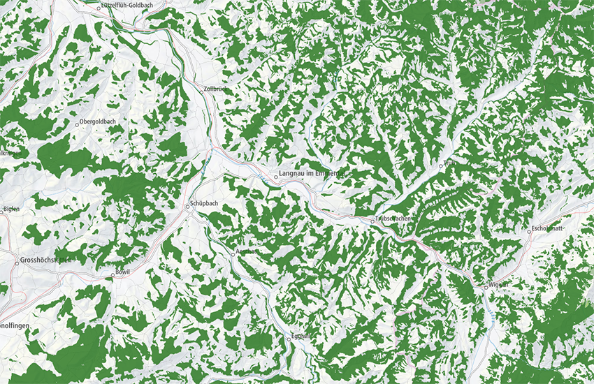
swissTLM3D Wald enthält die Waldflächen der Schweiz und des Fürstentums Liechtenstein. Sie sind Bestandteil des Datensatzes swissTLM3D. Mit seiner hohen Genauigkeit und dem Einbezug der dritten Dimension ist swissTLM3D der umfassendste 3D-Vektordatensatz der Schweiz. In swissTLM3D Wald sind die Objektarten «Wald», «Wald offen» und «Gebueschwald» unterschiedlich dargestellt.
swissTLM3D Forêt comprend les surfaces boisées de la Suisse et de la Principauté de Liechtenstein. Ils font partie du jeu de données swissTLM3D. Avec une haute précision et l'intégration de la troisième dimension, swissTLM3D constitue le jeu de données vectorielles en 3D le plus complet de la Suisse. Dans swissTLM3D Forêt, les types d'objets "Forêt", "Forêt clairsemée" et "Forêt buissonnante" sont représentés différemment.
swissTLM3D Foresta comprende le superfici forestali della Svizzera e del Principato del Liechtenstein e fa parte del set di dati swissTLM3D. Il prodotto swissTLM3D offre un'alta precisione e include anche la terza dimensione, si tratta della raccolta dati vettoriali in 3D più completa del territorio svizzero. In swissTLM3D Foresta i tipi di oggetto "Foresta", "Foresta rada" e "Arbusteto" sono rappresentati in modo diverso.
swissTLM3D Forest contains the forested areas of Switzerland and the Principality of Liechtenstein. It is part of the dataset swissTLM3D. With a high accuracy and the incorporation of a third dimension, swissTLM3D is the most extensive 3D vector data set of Switzerland. In swissTLM3D Forest, the object types "Forest", "Sparse forest" and "Bush forest" are represented differently.
swissTLM3D guaud cuntegna las surfatschas da guaud da la Svizra e dal Principadi da Liechtenstein. Ellas èn ina part integrala da l'unitad da datas swissTLM3D. Cun sia auta precisiun e cun l'integraziun da la terza dimensiun è swissTLM3D l'unitad da datas vectorialas en 3D la pli cumplessiva da la Svizra. En swissTLM3D guaud vegnan las categorias d'object «guaud», «guaud avert » e «guaud da chaglias» preschentadas en moda differenta.
Simple
-
Autre titreAltri nomi o acronimiAlternate titleAlternate titleAlternativtitel
-
Wald swissTLM3D
Forêt swissTLM3D
Foresta swissTLM3D
Forest swissTLM3D
Guaud swissTLM3D
-
Date (Création)Data (Creazione)Date (Creation)Date (Creation)Datum (Erstellung)
- 2020-03-18
-
Date (Révision)Data (Revisione)Date (Revision)Date (Revision)Datum (Aktualisierung)
- 2026-02-24
-
ÉditionEdizioneEditionEditionAusgabe
-
Version 2.4
-
Date d'éditionData di pubblicazioneEdition dateEdition dateAusgabedatum
- 2026-02-24T00:00:00
-
IdentifiantIdentificatoreIdentifierIdentifierKennung
- ch.swisstopo.swisstlm3d-wald
-
ÉtatStatoStatusStatusBearbeitungsstatus
-
ContinuIn corsoOn goingOn goingKontinuierliche Aktualisierung
Point de contact
Punto di contatto
Point of contact
Point of contact
Ansprechpartner
Propriétaire
Proprietario
Owner
Owner
Eigentümer
-
Type de représentation spatialeTipo di rappresentazione spazialeSpatial representation typeSpatial representation typeRäumliche Darstellungsart
-
vecteurVettorialeVectorVectorVektor
Résolution spatiale
Risoluzione spaziale
Spatial resolution
Spatial resolution
Räumliche Auflösung
Fraction représentative
Frazione rappresentativa
Equivalent scale
Equivalent scale
Vergleichsmassstab
-
DénominateurDenominatoreDenominatorDenominatorMassstabszahl
- 5000
Résolution spatiale
Risoluzione spaziale
Spatial resolution
Spatial resolution
Räumliche Auflösung
Fraction représentative
Frazione rappresentativa
Equivalent scale
Equivalent scale
Vergleichsmassstab
-
DénominateurDenominatoreDenominatorDenominatorMassstabszahl
- 25000
-
Catégorie de thèmeCategoria ISOTopic categoryTopic categoryThematik
-
-
A Imagerie, cartes de base et occupation du solA Mappe di base con immagini della copertura terrestreA Imagery base maps earth coverA Imagery base maps earth coverA Oberflächenbeschreibung
-
Étendue
Estensione
Extent
Extent
Ausdehnung
Étendue
Estensione
Extent
Extent
Ausdehnung
-
DescriptionDescrizioneDescriptionDescriptionBeschreibung
-
Switzerland
Schweiz
Suisse
Svizzera
Svizra
))

Étendue
Estensione
Extent
Extent
Ausdehnung
Étendue
Estensione
Extent
Extent
Ausdehnung
-
DescriptionDescrizioneDescriptionDescriptionBeschreibung
-
Liechtenstein
Liechtenstein
Liechtenstein
Liechtenstein
Liechtenstein
))

-
Fréquence de mise à jourFrequenza di aggiornamentoMaintenance and update frequencyMaintenance and update frequencyWartungsintervall
-
AnnuelleAnnualmenteAnnuallyAnnuallyJährlich
-
Remarque sur la mise à jourNota sull'aggiornamentoMaintenance noteMaintenance noteAnmerkung
-
Als Grundlage wurden bestehenden Daten in das TLM migriert. Nun werden sie gemäss einem Nachführungszyklus von 3 Jahren aktualisiert und es werden Verbesserungen und Ergänzungen von Geometrien und Attributen gemacht. Parallel zur der dreijährigen Nachführung soll mit der Integration von Daten sogenannter Referenzpartner für ausgewählte Themen eine jährliche Aktualisierung erreicht werden. Diese jährliche Aktualisierung ist vorderhand für die Hoheitsgrenzen und die Strassenachsen implementiert. Dabei nimmt die Amtliche Vermessung eine wichtige Rolle ein. Von der Amtlichen Vermessung werden zudem die Nomenklatur für die Nachführung des Themas Namen integriert.
Les données existantes ont été migrées dans le MTP afin de servir de base. Elles sont désormais actualisées selon un cycle de trois ans et des améliorations et compléments sont apportés pour les géométries et les attributs. Parallèlement à la mise à jour tous les trois ans, on vise de plus à une actualisation annuelle par l'intégration de données de partenaires dits de référence pour des thèmes choisis. Celle-ci est pour le moment réalisée pour les limites territoriales et les axes routiers. La mensuration officielle joue un rôle majeur dans ce contexte, en tant que partenaire de référence. Par ailleurs, la nomenclature pour la mise à jour du thème Noms provient également de la mensuration officielle.
I dati disponibili sono stati presi come base e trasferiti nel MTP. In seguito vengono attualizzati ogni tre anni, migliorati e completati con geometrie e attributi. Parallelamente all’aggiornamento previsto ogni tre anni, con l’integrazione dei dati dei cosiddetti partner di riferimento per un certo numero di temi prescelti, si intende procedere a un’attualizzazione annuale. Questa viene effettuata anzitutto per i confini territoriali e gli assi stradali e in tale contesto la Misurazione ufficiale svolge un ruolo di primo piano come partner di riferimento. Dalla Misurazione ufficiale viene ripresa anche la nomenclatura per l’aggiornamento del tema Nomi.
The existing data was migrated into the TLM as a basis. The data is now updated based on an update cycle of 3 years and improvements and additions are made to the geometries and attributes. Parallel to the three-year update process, an annual update is carried out through the integration of data from so-called reference partners for selected topics. Initially, this annual update is implemented mainly for the administrative boundaries and road links. The official cadastral survey plays an important role as a reference partner in this process. The nomenclature for updating names are also integrated from the official cadastral survey.
-
Durée de conservationDurata di conservazioneDuration of ConservationDuration of ConservationAufbewahrungsdauer NV in Jahren
- 275
-
Évaluation de la valeur archivistiqueValutazione del valore archivisticoAppraisal of Archival ValueAppraisal of Archival ValueBewertung Archivwürdigkeit
-
AAAAA
-
Raison de la valeur d'archivageMotivo del valore archivisticoReason for Archiving ValueReason for Archiving ValueBegründung Archivwürdigkeit
-
Preuve de la pratique couranteProva della pratica commercialeEvidence of business practiceEvidence of business practiceNachweis der Geschäftspraxis
- geocat.ch
-
-
surface boisée
superficie boschiva
wooded area
-
modèle du territoire
modello del territorio
landscape model
-
opendata.swiss
opendata.swiss
opendata.swiss
opendata.swiss
-
SIG (Système d'Information Géographique)
SIG (Sistema Informativo Geografico)
GIS (Geographic Information System)
-
Planification de la conservation et de l'archivage AAP - Conféderation
Pianificazione della conservazione e dell’archiviazione AAP - Confederazione
Conservation and archiving planning AAP - Confederation
-
couverture du sol
copertura del suolo
land cover
-
géodonnées de base
geodati di base
official geodata
-
- GEMET
-
-
bois
bosco
wood
-
système d'information géographique
sistema informativo geografico
geographic information system
-
vecteur
vettore
vector
-
- GEMET - INSPIRE themes, version 1.0
-
-
Dénominations géographiques
Nomi geografici
Geographical names
-
Occupation des terres
Copertura del suolo
Land cover
-
- geocat.ch
-
-
IFDG l’Infrastructure Fédérale de données géographiques
IFDG Infrastruttura federale dei dati geografici
FSDI Federal Spatial Data Infrastructure
-
Contraintes sur la ressource
Vincoli sulle risorse
Resource constraints
Resource constraints
Ressourcenbeschränkungen
-
Contraintes d'utilisationVincoli d'usoUse constraintsUse constraintsNutzungseinschränkungen
-
Autres restrictionsAltre restrizioniOther restrictionsOther restrictionsAndere Beschränkungen
-
Autres contraintesAltri vincoliOther constraintsOther constraintsAndere Einschränkungen
-
Freie Nutzung. Quellenangabe ist Pflicht.
Utilisation libre. Obligation d’indiquer la source.
Libero utilizzo. Indicazione della fonte obbligatoria.
NonCommercialAllowed-CommercialAllowed-ReferenceRequired
Ressource associée
Risorsa associata
Associated resource
Associated resource
Verlinkte Ressource
-
Type d'associationTipo di associazioneAssociation TypeAssociation TypeAssoziationstyp
-
Citation de travail plus largeCitazione di un'opera più ampiaReference to a master resource of which this one is a partReference to a master resource of which this one is a partÜbergeordneter Datenbestand
-
Metadata ReferenceRiferimento metadatiMetadata ReferenceMetadata ReferenceMetadatenreferenz
Ressource associée
Risorsa associata
Associated resource
Associated resource
Verlinkte Ressource
-
TitreTitoloTitleTitleTitel
-
Topografisches Landschaftsmodell (Landesvermessung)
Modèle topographique du paysage (mensuration nationale)
Modello topografico del paesaggio (misurazione nazionale)
topographical landscape model (national survey)
-
Type d'associationTipo di associazioneAssociation TypeAssociation TypeAssoziationstyp
-
Citation de travail plus largeCitazione di un'opera più ampiaReference to a master resource of which this one is a partReference to a master resource of which this one is a partÜbergeordneter Datenbestand
-
LangueLinguaLanguageLanguageSprache
- Deutsch
-
Encodage de caractèresCodifica dei caratteriCharacter encodingCharacter encodingZeichenkodierung
-
Utf8UTF8UTF8UTF8Utf8
-
Catégorie de sous-thèmeCategoria di sottotemaSubtopic CategorySubtopic CategoryThematische Unterkategorien
-
A1 Cartes de base, modèles de paysageA1 Mappe di base, modelli paesaggisticiA1 Base Maps, Landscape ModelsA1 Base Maps, Landscape ModelsA1 Basiskarten, Landschaftsmodelle
-
Géodonnées de baseGeodati di baseBasic GeodataBasic GeodataGeobasisdaten
- true
-
Identifiant Géodonnées de baseIdentificativo dei geodati di baseBasic Geodata IDBasic Geodata IDIdentifikator des Geobasisdatensatzes
-
38.1
-
Niveau des géodonnées de baseLivello legale dei geodati di baseBasic Geodata Legal LevelBasic Geodata Legal LevelGeobasisdatenebene
-
FédéralFederaleFederalFederalNational
-
Type de géodonnées de baseTipo di geodati di baseBasic Geodata TypeBasic Geodata TypeGeobasisdatentyp
-
Géodonnées de référenceGeodati di riferimentoReference GeodataReference GeodataGeoreferenzdaten
-
Livré avec jeu de donnéesFornito con set di datiIncluded with datasetIncluded with datasetMit Datensatz geliefert
- false
-
TitreTitoloTitleTitleTitel
-
Objektkatalog swissTLM3D 2.4
Cataloque des objets swissTLM3D 2.1
-
Date (Révision)Data (Revisione)Date (Revision)Date (Revision)Datum (Aktualisierung)
- 2026-02-24
-
Format de distributionFormato (codifica)Distribution formatDistribution formatAbgabeformat
-
-
ESRI File Geodatabase FileGDB (GDB)
-
ESRI Shapefile (SHP)
-
AutoCAD DXF (DXF)
-
INTERLIS 2 (XTF)
-
OGC Geopackage (GPKG)
-
Options de transfert numérique
Opzioni di trasferimento digitale
Digital transfer options
Digital transfer options
Optionen für die digitale Übertragung
-
Ressource en ligneRisorsa onlineOnLine resourceOnLine resourceOnline
-
Vorschau map.geo.admin.ch
Vorschau map.geo.admin.chAperçu map.geo.admin.chPrevisione map.geo.admin.chPreview map.geo.admin.ch
Options de transfert numérique
Opzioni di trasferimento digitale
Digital transfer options
Digital transfer options
Optionen für die digitale Übertragung
-
Ressource en ligneRisorsa onlineOnLine resourceOnLine resourceOnline
-
ch.swisstopo.swisstlm3d-wald
WMS-BGDI Dienst, Layer "Wald swissTLM3D"Service WMS-IFDG, couche "Forêt swissTLM3D"Servizio WMS-IFDG, strato "Foresta swissTLM3D"WMS-FSDI service, layer "Forest swissTLM3D"WMS-BGDI Dienst, Layer "Wald swissTLM3D"
Options de transfert numérique
Opzioni di trasferimento digitale
Digital transfer options
Digital transfer options
Optionen für die digitale Übertragung
-
Ressource en ligneRisorsa onlineOnLine resourceOnLine resourceOnline
-
ch.swisstopo.swisstlm3d-wald
WMTS-BGDI Dienst, Layer "Wald swissTLM3D"Service WMTS-IFDG, couche , Layer "Forêt swissTLM3D"Servizio WMTS-IFDG, strato "Foresta swissTLM3D"WMTS-FSDI service, layer "Forest swissTLM3D"WMTS-BGDI Dienst, Layer "Wald swissTLM3D"
Options de transfert numérique
Opzioni di trasferimento digitale
Digital transfer options
Digital transfer options
Optionen für die digitale Übertragung
Options de transfert numérique
Opzioni di trasferimento digitale
Digital transfer options
Digital transfer options
Optionen für die digitale Übertragung
-
Généralités sur la provenanceInformazioni generali sulla provenienzaStatementStatementErklärung
-
Geometrische Genauigkeit von swissTLM3D: 0.2 -1.5 m in allen drei Dimensionen für gut definierte Objekte wie z.B. Strassen und Gebäude; 1 - 3 m in allen drei Dimensionen für nicht klar abgrenzbare Objekte wie z.B. Wald
Précision géométrique de swissTLM3D: 0,2 -1,5 m dans les trois dimensions pour des objets bien définis, par ex. routes et bâtiments; 1 - 3 m dans les trois dimensions pour les objets non délimitables clairement, par ex. forêts)
Precisione geometrica di swissTLM3D: 0.2 -1.5 m in ognuna delle tre dimensioni per oggetti ben definiti quali ad es. strade e edifici; 1 - 3 m in ognuna delle tre dimensioni per oggetti dai contorni meno netti quali ad es. le foreste).
Geometric accuracy of swissTLM3D: 0.2 -1.5 m in all three dimensions for well-defined landscape features such as roads and buildings; 1 - 3 m in all three dimensions for landscape features which are not clearly defined such as forests)
-
NiveauLivelloHierarchy levelHierarchy levelBezugsebene
-
Jeu de donnéesSet di datiDatasetDatasetDatenbestand
-
Nom du système de référenceNome del sistema di riferimentoReference system identifierReference system identifierName des Referenzsystems
- EPSG:2056
-
Nom du système de référenceNome del sistema di riferimentoReference system identifierReference system identifierName des Referenzsystems
- EPSG:5728
Metadata
-
Identifiant des métadonnéesIdentificativo della schedaMetadata identifierMetadata identifierIdentifikator des Metadatensatzes
- cdb289d5-db16-4440-8529-5807a262f6a2
-
LangueLinguaLanguageLanguageSprache
- Deutsch
-
Encodage de caractèresCodifica dei caratteriCharacter encodingCharacter encodingZeichenkodierung
-
Utf8UTF8UTF8UTF8Utf8
-
LangueLinguaLanguageLanguageSprache
- Français
-
Encodage de caractèresCodifica dei caratteriCharacter encodingCharacter encodingZeichenkodierung
-
Utf8UTF8UTF8UTF8Utf8
-
LangueLinguaLanguageLanguageSprache
- Italiano
-
Encodage de caractèresCodifica dei caratteriCharacter encodingCharacter encodingZeichenkodierung
-
Utf8UTF8UTF8UTF8Utf8
-
LangueLinguaLanguageLanguageSprache
- English
-
Encodage de caractèresCodifica dei caratteriCharacter encodingCharacter encodingZeichenkodierung
-
Utf8UTF8UTF8UTF8Utf8
-
LangueLinguaLanguageLanguageSprache
- Rumantsch
-
Encodage de caractèresCodifica dei caratteriCharacter encodingCharacter encodingZeichenkodierung
-
Utf8UTF8UTF8UTF8Utf8
Point de contact
Punto di contatto
Point of contact
Point of contact
Ansprechpartner
-
Heures de serviceOrario di servizioHours of serviceHours of serviceBetriebszeiten
-
08h30 - 11h00 / 14h00 - 16h00 GMT+1
Type de ressource
Tipo di risorsa
Type of resource
Type of resource
Anwendungsbereich der Metadaten
-
Domaine d'application de la ressourceAmbito di applicazione della risorsaResource scopeResource scopeDomäne der Ressourcenanwendung
-
Jeu de donnéesSet di datiDatasetDatasetDatenbestand
-
Lien vers la métadonnéeCollegamento ai metadatiMetadata linkageMetadata linkageLink zu den Metadaten
-
Informations de date (Création)Informazioni sulla data (Creazione)Date info (Creation)Date info (Creation)Datumsangaben (Erstellung)
- 2020-04-22T11:46:04Z
-
Informations de date (Révision)Informazioni sulla data (Revisione)Date info (Revision)Date info (Revision)Datumsangaben (Aktualisierung)
- 2026-05-27T10:16:44.281184Z
Norme des métadonnées
Standard dei metadati
Metadata standard
Metadata standard
Metadatenstandard
-
TitreTitoloTitleTitleTitel
-
eCH-0271