geocat.ch
Geologische Karte der Schweiz 1:500000
Carte géologique de la Suisse au 1:500000
Carta geologica della Svizzera 1:500000
Geological Map of Switzerland 1:500000
Charta geologica da la Svizra 1:500000
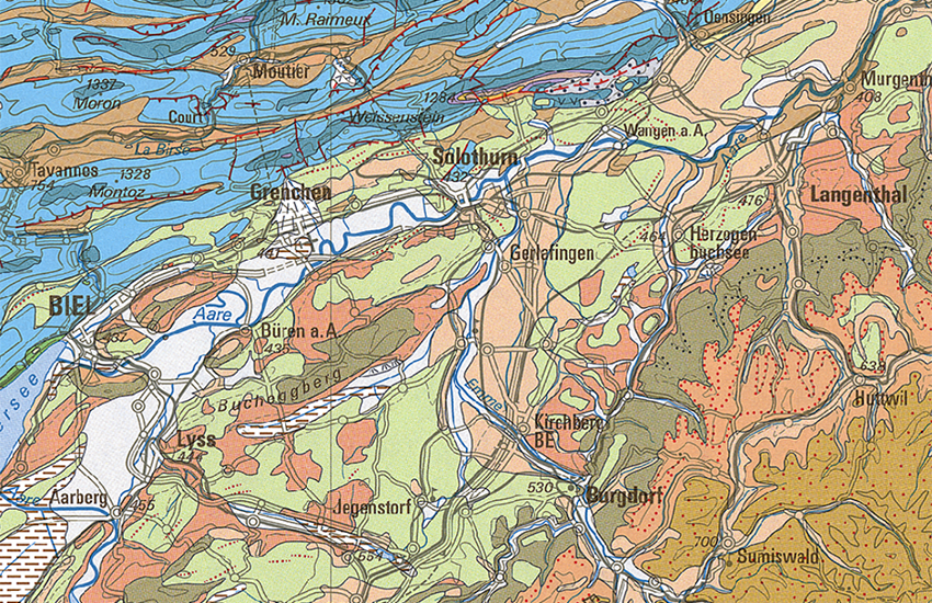
Die Geologische Karte der Schweiz 1:500`000 (GK500-Geol) deckt die gesamte Schweiz und das angrenzende Ausland ab. Sie gibt einen Überblick über die Verteilung der in der Schweiz auftretenden obersten Gesteinsschichten. Sie liefert somit eine wichtige Datengrundlage und ein Werkzeug für das bessere Verständnis unserer Umwelt zwecks einer nachhaltigen Entwicklung. Sie ist ein unumgängliches Hilfsmittel für die Ausbildung in den Bereichen Erd- und Umweltwissenschaften und Naturgefahren.
La carte géologique de la Suisse au 1:500`000 (GK500-Geol) donne un aperçu des couches géologiques superficielles de tout le territoire suisse et des régions limitrophes. Elle donne un aperçu des couches géologiques superficielles. Il s’agit donc d’une importante base de données et d’un outil aidant à mieux comprendre notre environnement dans l’optique d`un développement durable. C’est un auxiliaire indispensable pour la formation dans les domaines des sciences de la terre, de l`environnement et des dangers naturels.
La Carta geologica della Svizzera 1:50'000 (GK500-Geol) copre tutto il territorio della Svizzera e delle regioni limitrofe. Essa offre una visione d'insieme della distribuzione degli strati geologici superficiali presenti in Svizzera e costituisce pertanto un'importante banca dati e uno strumento volto a favorire una migliore comprensione del nostro ambiente ai fini di uno sviluppo sostenibile. Essa costituisce inoltre uno strumento imprescindibile per la formazione nel campo delle scienze della terra, delle scienze ambientali e dei pericoli naturali.
The 1:500,000 Geological Map of Switzerland covers the whole of Switzerland and adjoining parts of neighbouring countries. It gives an overview of the distribution of the uppermost rock strata occurring in Switzerland. Therefore, it provides an important data base and functions as a tool for gaining a better understanding of our environment in the scope of sustainable development. It is an essential aid for education in the fields of environmental and earth sciences, as well as natural hazards.
La Charta geologica da la Svizra 1:500'000 (GK500-Geol) cumpiglia l'entira Svizra e l'exteriur vischin. Ella dat ina survista da las stresas da crappa superiuras en Svizra. Quai è pia ina basa da datas impurtanta ed in utensil per chapir meglier noss ambient a favur d'in svilup duraivel. Questa charta è in med auxiliar indispensabel per la scolaziun en ils secturs da las scienzas da la terra e da las scienzas da l'ambient e da l'ecologia sco er dals privels da la natira.
Simple
-
Autre titreAltri nomi o acronimiAlternate titleAlternate titleAlternativtitel
-
Geologie 500
Géologie 500
Geologia 500
Geology 500
Geologia 500
-
Date (Publication)Data (Pubblicazione)Date (Publication)Date (Publication)Datum (Publikation)
- 2005-12-31
-
Date (Création)Data (Creazione)Date (Creation)Date (Creation)Datum (Erstellung)
- 1980-01-01T00:00:00
-
IdentifiantIdentificatoreIdentifierIdentifierKennung
- ch.swisstopo.geologie-geologische_karte
-
Forme de la présentationForma della presentazionePresentation formPresentation formPräsentationsform
-
Carte papierMappa cartaceaHardcopy mapHardcopy mapPapierkarte
-
Forme de la présentationForma della presentazionePresentation formPresentation formPräsentationsform
-
Carte numériqueMappa digitaleDigital mapDigital mapDigitale Karte
-
NomNomeNameNameName
-
GeoKarten 500
-
ButScopoPurposePurposeZweck
-
Übersicht über die Geologie der Schweiz
Vue d’ensemble de la géologie en Suisse
-
ÉtatStatoStatusStatusBearbeitungsstatus
-
TerminéCompletatoCompletedCompletedAbgeschlossen
Distributeur
Distributore
Distributor
Distributor
Verteiler
Point de contact
Punto di contatto
Point of contact
Point of contact
Ansprechpartner
Propriétaire
Proprietario
Owner
Owner
Eigentümer
-
Type de représentation spatialeTipo di rappresentazione spazialeSpatial representation typeSpatial representation typeRäumliche Darstellungsart
-
grilleRasterGridGridRaster, Gitter
-
Type de représentation spatialeTipo di rappresentazione spazialeSpatial representation typeSpatial representation typeRäumliche Darstellungsart
-
vecteurVettorialeVectorVectorVektor
-
Type de représentation spatialeTipo di rappresentazione spazialeSpatial representation typeSpatial representation typeRäumliche Darstellungsart
-
paperMappaperMappaperMappaperMappaperMap
Résolution spatiale
Risoluzione spaziale
Spatial resolution
Spatial resolution
Räumliche Auflösung
Fraction représentative
Frazione rappresentativa
Equivalent scale
Equivalent scale
Vergleichsmassstab
-
DénominateurDenominatoreDenominatorDenominatorMassstabszahl
- 500000
-
Catégorie de thèmeCategoria ISOTopic categoryTopic categoryThematik
-
-
F Informations géoscientifiquesF Informazioni geoscientificheF Geoscientific informationF Geoscientific informationF Erdwissenschaften
-
Étendue
Estensione
Extent
Extent
Ausdehnung
Étendue
Estensione
Extent
Extent
Ausdehnung
-
DescriptionDescrizioneDescriptionDescriptionBeschreibung
-
National Map 1:500'000
Landeskarte 1:500'000
Carte nationale 1:500'000
Carta nazionale 1:500'000
Landeskarte 1:500'000
-
Identifiant géographiqueIdentificatore geograficoGeographic identifierGeographic identifierGeografische Kennung
- NM500LK500CN500CN500LK500
))

-
Fréquence de mise à jourFrequenza di aggiornamentoMaintenance and update frequencyMaintenance and update frequencyWartungsintervall
-
Comme nécessaireSecondo necessitàAs neededAs neededBei Bedarf
-
Durée de conservationDurata di conservazioneDuration of ConservationDuration of ConservationAufbewahrungsdauer NV in Jahren
- 275
-
Évaluation de la valeur archivistiqueValutazione del valore archivisticoAppraisal of Archival ValueAppraisal of Archival ValueBewertung Archivwürdigkeit
-
AAAAA
-
Raison de la valeur d'archivageMotivo del valore archivisticoReason for Archiving ValueReason for Archiving ValueBegründung Archivwürdigkeit
-
Preuve de la pratique couranteProva della pratica commercialeEvidence of business practiceEvidence of business practiceNachweis der Geschäftspraxis
- geocat.ch
-
-
géodonnées de base
geodati di base
official geodata
-
roche cohérente
roccia coerente
well-consolidated rock
-
e-geo.ch
e-geo.ch
e-geo.ch
-
Planification de la conservation et de l'archivage AAP - Conféderation
Pianificazione della conservazione e dell’archiviazione AAP - Confederazione
Conservation and archiving planning AAP - Confederation
-
carte géologique
carta geologica
geologic map
-
opendata.swiss
opendata.swiss
opendata.swiss
opendata.swiss
-
- GEMET - INSPIRE themes, version 1.0
-
-
Géologie
Geologia
Geology
-
- GEMET
-
-
sciences de la terre
scienze della terra
earth science
-
pierre
pietra (edilizia)
stone
-
sédimentation
sedimentazione (geologia)
sedimentation (geology)
-
- geocat.ch
-
-
IFDG l’Infrastructure Fédérale de données géographiques
IFDG Infrastruttura federale dei dati geografici
FSDI Federal Spatial Data Infrastructure
-
Ressource associée
Risorsa associata
Associated resource
Associated resource
Verlinkte Ressource
-
TitreTitoloTitleTitleTitel
-
Geologisches Kartenwerk
Cartes géologiques
Carte geologiche
Geological maps
-
Type d'associationTipo di associazioneAssociation TypeAssociation TypeAssoziationstyp
-
Citation de travail plus largeCitazione di un'opera più ampiaReference to a master resource of which this one is a partReference to a master resource of which this one is a partÜbergeordneter Datenbestand
-
LangueLinguaLanguageLanguageSprache
- Deutsch
-
Encodage de caractèresCodifica dei caratteriCharacter encodingCharacter encodingZeichenkodierung
-
Utf8UTF8UTF8UTF8Utf8
-
LangueLinguaLanguageLanguageSprache
- Français
-
Encodage de caractèresCodifica dei caratteriCharacter encodingCharacter encodingZeichenkodierung
-
Utf8UTF8UTF8UTF8Utf8
-
Informations supplémentairesInformazioni supplementariSupplemental InformationSupplemental InformationZusätzliche Informationen
-
Dieses Produkt ist Bestandteil der Serie der Geokarten 500 und ist als Druckversion (gefalzt oder plano), Pixelkarte oder Vektordatensatz erhältlich.
Ce produit fait partie de la série des GéoCartes 500. Il est disponible en version imprimée (plié ou plano), carte-pixel et jeux de données vectorielles.
-
Catégorie de sous-thèmeCategoria di sottotemaSubtopic CategorySubtopic CategoryThematische Unterkategorien
-
F1 GéologieF1 GeologiaF1 GeologyF1 GeologyF1 Geologie
-
Géodonnées de baseGeodati di baseBasic GeodataBasic GeodataGeobasisdaten
- true
-
Identifiant Géodonnées de baseIdentificativo dei geodati di baseBasic Geodata IDBasic Geodata IDIdentifikator des Geobasisdatensatzes
-
46.4
-
Niveau des géodonnées de baseLivello legale dei geodati di baseBasic Geodata Legal LevelBasic Geodata Legal LevelGeobasisdatenebene
-
FédéralFederaleFederalFederalNational
-
Niveau de responsabilité des géodonnées de baseLivello di responsabilità dei geodati di baseBasic Geodata Responsibility LevelBasic Geodata Responsibility LevelInformationen über die Zuständigkeitsebene der Geobasisdaten
-
FédéralFederaleFederalFederalNational
-
Niveau d'accès des géodonnées de baseLivello di accesso ai geodati di baseBasic Geodata Access LevelBasic Geodata Access LevelInformationen über die Zugangsberechtigungsstufe zu Geobasisdaten
-
AAAAA
-
Format de distributionFormato (codifica)Distribution formatDistribution formatAbgabeformat
-
-
analog
-
GeoTIFF (GEOTIFF)
-
ESRI Shapefile (SHP)
-
Options de transfert numérique
Opzioni di trasferimento digitale
Digital transfer options
Digital transfer options
Optionen für die digitale Übertragung
-
Ressource en ligneRisorsa onlineOnLine resourceOnLine resourceOnline
-
Vorschau map.geo.admin.ch
Vorschau map.geo.admin.chAperçu map.geo.admin.chPrevisione map.geo.admin.chPreview map.geo.admin.ch
Options de transfert numérique
Opzioni di trasferimento digitale
Digital transfer options
Digital transfer options
Optionen für die digitale Übertragung
-
Ressource en ligneRisorsa onlineOnLine resourceOnLine resourceOnline
-
ch.swisstopo.geologie-geologische_karte
WMS-BGDI Dienst, Layer "Geologie 500"Service WMS-IFDG, couche "Géologie 500"Servizio WMS-IFDG, strato "Geologia 500"WMS-FSDI service, layer "Geology 500"WMS-BGDI Dienst, Layer "Geologie 500"
Options de transfert numérique
Opzioni di trasferimento digitale
Digital transfer options
Digital transfer options
Optionen für die digitale Übertragung
-
Ressource en ligneRisorsa onlineOnLine resourceOnLine resourceOnline
-
ch.swisstopo.geologie-geologische_karte
WMTS-BGDI Dienst, Layer "Geologie 500"Service WMTS-IFDG, couche , Layer "Géologie 500"Servizio WMTS-IFDG, strato "Geologia 500"WMTS-FSDI service, layer "Geology 500"WMTS-BGDI Dienst, Layer "Geologie 500"
Options de transfert numérique
Opzioni di trasferimento digitale
Digital transfer options
Digital transfer options
Optionen für die digitale Übertragung
Options de transfert numérique
Opzioni di trasferimento digitale
Digital transfer options
Digital transfer options
Optionen für die digitale Übertragung
Options de transfert numérique
Opzioni di trasferimento digitale
Digital transfer options
Digital transfer options
Optionen für die digitale Übertragung
Options de transfert numérique
Opzioni di trasferimento digitale
Digital transfer options
Digital transfer options
Optionen für die digitale Übertragung
Options de transfert numérique
Opzioni di trasferimento digitale
Digital transfer options
Digital transfer options
Optionen für die digitale Übertragung
Options de transfert numérique
Opzioni di trasferimento digitale
Digital transfer options
Digital transfer options
Optionen für die digitale Übertragung
-
Ressource en ligneRisorsa onlineOnLine resourceOnLine resourceOnline
-
RESTful API von geo.admin.ch
RESTful API von geo.admin.chRESTful API de geo.admin.chRESTful API da geo.admin.chRESTful API from geo.admin.chRESTful API dad geo.admin.ch
-
Généralités sur la provenanceInformazioni generali sulla provenienzaStatementStatementErklärung
-
Gegenüber der vorhergehenden Ausgabe, die vor mehr als 25 Jahren erschien, zeigt die aktuelle Auflage einen deutlich verbesserten Detaillierungsgrad. Die neuen und überarbeiteten geologischen Daten der letzten Jahrzehnte sind in die aktuelle Auflage mit eingeflossen. Die detailliertere Legende ist dank eines überarbeiteten Layouts nun leichter lesbar und damit besser verständlich. Topografische Basis ist die Landeskarte 1:500'000 aus dem Jahr 2005.
Par rapport à l’édition précédente parue voilà plus de 25 ans, la version actuelle présente un degré de détail nettement accru. Les données géologiques nouvelles et révisées des dernières décennies ont été intégrées dans l’édition actuelle. La légende, plus détaillée, est plus facile à lire, et de ce fait à comprendre, grâce à une présentation remaniée. La base topographique est la Carte national au 1:500'000 de l'année 2005.
-
NiveauLivelloHierarchy levelHierarchy levelBezugsebene
-
Jeu de donnéesSet di datiDatasetDatasetDatenbestand
-
Nom du système de référenceNome del sistema di riferimentoReference system identifierReference system identifierName des Referenzsystems
- Referenzsystem entsprechend der zugrundeliegenden topographischen Karte (CH1903)
Metadata
-
Identifiant des métadonnéesIdentificativo della schedaMetadata identifierMetadata identifierIdentifikator des Metadatensatzes
- ca917a71-dcc9-44b6-8804-823c694be516
-
LangueLinguaLanguageLanguageSprache
- Deutsch
-
Encodage de caractèresCodifica dei caratteriCharacter encodingCharacter encodingZeichenkodierung
-
Utf8UTF8UTF8UTF8Utf8
-
LangueLinguaLanguageLanguageSprache
- Français
-
Encodage de caractèresCodifica dei caratteriCharacter encodingCharacter encodingZeichenkodierung
-
Utf8UTF8UTF8UTF8Utf8
-
LangueLinguaLanguageLanguageSprache
- Italiano
-
Encodage de caractèresCodifica dei caratteriCharacter encodingCharacter encodingZeichenkodierung
-
Utf8UTF8UTF8UTF8Utf8
-
LangueLinguaLanguageLanguageSprache
- English
-
Encodage de caractèresCodifica dei caratteriCharacter encodingCharacter encodingZeichenkodierung
-
Utf8UTF8UTF8UTF8Utf8
-
LangueLinguaLanguageLanguageSprache
- Rumantsch
-
Encodage de caractèresCodifica dei caratteriCharacter encodingCharacter encodingZeichenkodierung
-
Utf8UTF8UTF8UTF8Utf8
Point de contact
Punto di contatto
Point of contact
Point of contact
Ansprechpartner
Type de ressource
Tipo di risorsa
Type of resource
Type of resource
Anwendungsbereich der Metadaten
-
Domaine d'application de la ressourceAmbito di applicazione della risorsaResource scopeResource scopeDomäne der Ressourcenanwendung
-
Jeu de donnéesSet di datiDatasetDatasetDatenbestand
-
Lien vers la métadonnéeCollegamento ai metadatiMetadata linkageMetadata linkageLink zu den Metadaten
-
Informations de date (Création)Informazioni sulla data (Creazione)Date info (Creation)Date info (Creation)Datumsangaben (Erstellung)
- 2009-10-14T12:00:00Z
-
Informations de date (Révision)Informazioni sulla data (Revisione)Date info (Revision)Date info (Revision)Datumsangaben (Aktualisierung)
- 2026-06-05T09:29:26.164956Z
Norme des métadonnées
Standard dei metadati
Metadata standard
Metadata standard
Metadatenstandard
-
TitreTitoloTitleTitleTitel
-
eCH-0271