geocat.ch
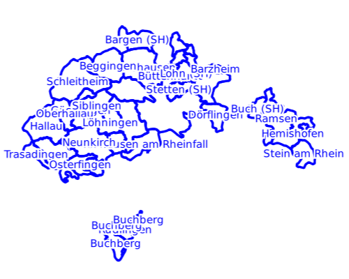
Gemeindegrenzen (Stand 2000) Kanton Schaffhausen
Ehemals selbständige politische Gemeinden im Kanton Schaffhausen mit Stand 2000, die sich seitdem an andere Gemeinde angeschlossen haben und in diesem Datensatz als Ortsteile abgebildet sind. Fusion: 2004 (Barzheim), 2005 (Osterfingen), 2009 (Altdorf, Bibern, Hemmental, Hofen, Opfertshofen), 2013 (Guntmadingen)
Simple
- Date (Revision)
- 2026-06-20
- Date (Creation)
- 2020-08-05
- Status
- On going
Point of contact
Owner
- Topic category
-
- D Boundaries
Extent
Extent
- Description
-
Kanton Schaffhausen
N
S
E
W
))

- Maintenance and update frequency
- Daily
- Duration of Conservation
- 0
- Comment on Duration of Conservation
-
Aufbewahrungsfrist unbekannt.
- Appraisal of Archival Value
- A
- Reason for Archiving Value
- Evidence of business practice
- Keywords
-
-
Administrative Einteilungen
-
Historische Gemeindegrenzen
-
Gemeindefusion
-
Ortsteile
-
opendata.swiss
-
Resource constraints
- Other constraints
- Freie Nutzung
Associated resource
- Association Type
- Reference to a master resource of which this one is a part
- Language
- Deutsch
- Character encoding
- UTF8
- Basic Geodata
- false
- Basic Geodata Type
- openGovernmentData
- Distribution format
-
-
DXF/DWG
-
WMS Dienst
-
ESRI Shapefile
-
Geopackage
-
WFS Dienst
-
Distributor
Digital transfer options
- OnLine resource
-
(GeoPackage, DXF, Shapefile)
(GeoPackage, DXF, Shapefile)
Digital transfer options
- OnLine resource
-
Kanton Schaffhausen
Kanton Schaffhausen
Digital transfer options
- OnLine resource
-
Kanton Schaffhausen
Kanton Schaffhausen
- Reference system identifier
- 2056
- Maintenance and update frequency
- Daily
Metadata
- Metadata identifier
- c99f8d7a-3fe8-4867-ac08-0f82f9de693f
- Language
- Deutsch
- Character encoding
- UTF8
Point of contact
Type of resource
- Resource scope
- Dataset
- Date info (Revision)
- 2026-06-20T00:00:00
Metadata standard
- Title
-
GM03 2+