 geocat.ch
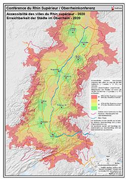
Accessibilité des villes du Rhin supérieur - 2020 PDF / Erreichbarkeit der Städte im Oberrhein - 2020 PDF
Carte PDF de l'accessibilité des villes du Rhin supérieur - 2020 /
PDF Karte der erreichbarkeit der Städte im Oberrhein - 2020
Simple
- Date (Creation)
- 2020-04-15
- Presentation form
- Hardcopy map
- Status
- Completed
- Topic category
-
- B Location
Extent
Extent
N
S
E
W
))
Temporal extent
- Time period
- 2020-01-01 2030-01-01
- Maintenance and update frequency
- Unknown
- Keywords
-
-
accessibilité;villes;erreichbarkeit;Städte;Rhin supérieur;PDF;carte;Karte
-
Resource constraints
- Use limitation
-
GeoRhena
- Language
- Français
- Distribution format
-
-
PDF
-
Digital transfer options
- OnLine resource
- Ouvrir la carte statique PDF / Die PDF Karte öffnen
Metadata
- Metadata identifier
- c69f9d6d-fd43-40f6-9109-f6e8882e3fb5
- Language
- Français
- Character encoding
- UTF8
Type of resource
- Resource scope
- staticMap
- Name
-
1
- Date info (Revision)
- 2025-06-17T14:54:45.037817Z
Metadata standard
- Title
-
ISO 19115-3:2018
- Edition
-
1.0
)))