geocat.ch
Sommets 4000m
Suite à la demande de Valais Tourisme, ce jeu de données a été élaboré sur la base des indications d'altitude des noms inscrits dans SwissNames3D, état 2013. Les critères de la "International Climbing and Mountaineering Association (UIAA)" pour identifier les sommets de montagnes de plus de 4000m d'altitude ont été appliqués.
Simple
- Date (Creation)
- 2013-08-09
- Identifier
- 413
- Purpose
-
Mettre à disposition des géodonnées des sommets de plus de 4000m pour le tourisme
- Status
- Completed
Custodian
- Spatial representation type
- Vector
Spatial resolution
Equivalent scale
- Denominator
- 25000
- Topic category
-
- T Economy
Extent
Extent
- Description
-
Canton of Valais (VS)
))

- Maintenance and update frequency
- Not planned
Resource format
- Title
-
ESRI Enterprise Geodatabase
- Date
- GEMET themes
-
-
tourism
-
- GEMET
-
-
altitude
-
mountain
-
- geocat.ch
-
-
topography
-
opendata.swiss
-
Resource constraints
- Use limitation
-
aucune
Resource constraints
- Access constraints
- Other restrictions
- Other constraints
-
Géodonnées accessibles au public (niveau A selon l'OGéo)
- Other constraints
-
Les conditions générales d'utilisation des géodonnées du Canton du Valais font foi ( https://www.vs.ch/fr/web/guest/information-legale).
- Language
- Français
- Character encoding
- UTF8
- Environment description
-
S:\Géodonnées VS\T Activités économiques\Sommets 4000m.lyr
- Basic Geodata
- false
- Basic Geodata Type
- openGovernmentData
- Distribution format
-
-
ESRI Shapefile (SHP)
-
autres formats sur demande / andere Formate auf Anfrage
-
ArcGIS REST Feature Service
-
Distributor
Digital transfer options
- OnLine resource
-
Géoportail du Canton du Valais
Géoportail du Canton du Valais
Digital transfer options
- OnLine resource
-
Landing Page
Landing Page pour opendata
Digital transfer options
- OnLine resource
-
OpenData Valais
Site de téléchargement de géodonnées à l'Etat du Valais: multiformat et WebMercator
Digital transfer options
- OnLine resource
-
Permalink opendata.swiss
Permalink opendata.swiss
Digital transfer options
- OnLine resource
-
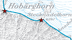
sommets
Carte des sommets de plus de 4000m d'altitude
- Statement
-
SwissNames3D, UIAA
- Hierarchy level
- Dataset
- Description
-
Sélection
- Geometric object type
- Point
- Geometric object count
- 46
- Reference system identifier
- EPSG:2056/CH1903+_MN95
Metadata
- Metadata identifier
- c68fd19b-0e7e-4cbe-b914-bab9981a112c
- Language
- Français
- Character encoding
- UTF8
- Language
- Deutsch
- Character encoding
- UTF8
- Language
- Italiano
- Character encoding
- UTF8
- Language
- English
- Character encoding
- UTF8
- Language
- Rumantsch
- Character encoding
- UTF8
Distributor
Type of resource
- Resource scope
- Dataset
- Metadata linkage
-
https://www.geocat.ch/geonetwork/srv/api/records/c68fd19b-0e7e-4cbe-b914-bab9981a112c
- Date info (Creation)
- 2016-12-06T09:45:47Z
- Date info (Revision)
- 2026-04-13T09:34:02.211139Z
Metadata standard
- Title
-
eCH-0271