geocat.ch
Agricultural Greenhouse Gas Emissions MAUS
Based on legal provisions (Art. 185 para. 1bis SR 910.1, Art. 8 and 9 SR 919.118, Annex 1, item 09.24 SR 431.011), Agroscope and the Federal Office for Agriculture conduct agri-environmental monitoring (Monitoring of the Swiss Agri-Environmental System = MAUS). MAUS calculates various agri-environmental indicators that highlight the environmental impacts of agriculture and illustrate their development over time across different regions and production systems. The calculations are based on both existing data and own surveys.
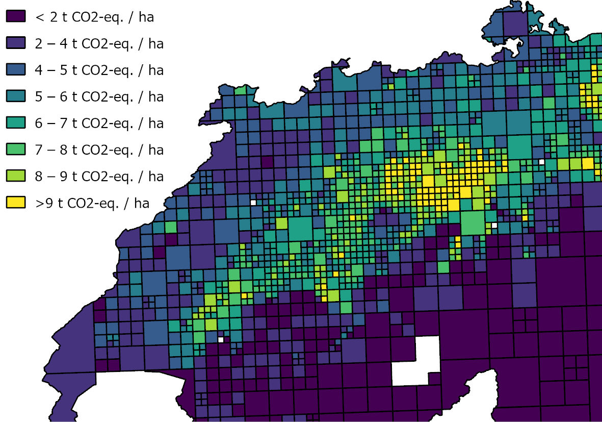
Each agri-environmental indicator was calculated individually for each farm. For presentation on maps, the results were subsequently converted into an adaptive grid using the R package. This allows for a more detailed resolution of the values in areas with a higher farm density than in areas with few farms, while simultaneously ensuring data protection by aggregating at least 10 farms in each grid cell.
Greenhouse gas emissions are responsible for global warming. Here, we calculate the following greenhouse gas emissions in accordance with IPCC guidelines: 1A4c energy-related emissions (carbon dioxide; agriculture only), 3A enteric fermentation (methane), 3B manure management (methane, nitrous oxide), 3D agricultural soils (nitrous oxide), 3G liming (carbon dioxide), and 3H urea application (carbon dioxide). The agri-environmental indicator for greenhouse gas emissions is calculated using the SAGE model (Gilgen & Schneuwly et al. 2026). A more detailed description of the methodology and the data sources used is available for download on geocat.
The published dataset comprises a database containing the indicators for 2021, 2022 and 2023, each as a separate feature dataset.
References:
Gilgen, A. & Schneuwly, J., C. Zosso, L. Merbold, D. Bretscher (2026): New approach to calculate agri-environmental indicators using greenhouse gas emissions in Switzerland as an example. https://doi.org/10.1016/j.agsy.2026.104887
Simple
- Alternate title
-
MAUS GHG-emissions
- Date (Creation)
- 2025-04-06
- Date (Publication)
- 2026-10
- Date (Revision)
- 2021-01
- Date (Revision)
- 2022-01
- Date (Revision)
- 2023-01
- Date (Revision)
- 2024-01
- Status
- On going
Owner
Point of contact
Processor
- Spatial representation type
- Vector
Spatial resolution
Equivalent scale
- Denominator
- 200000
- Temporal resolution
-
P1Y0M0DT0H0M0S
- Topic category
-
- S Farming
Extent
Extent
- Description
-
Switzerland
))

- Maintenance and update frequency
- Annually
- geocat.ch
-
-
agricultural exploitation
-
- GEMET
-
-
greenhouse gas
-
monitoring
-
indicator
-
agriculture
-
greenhouse gas emissions
-
Associated resource
- Association Type
- Part of same structured set of data held in a computer
- Metadata Reference
- Language
- Deutsch
- Character encoding
- UTF8
- Language
- Français
- Character encoding
- UTF8
- Language
- English
- Character encoding
- UTF8
- Language
- Italiano
- Character encoding
- UTF8
- Language
- Rumantsch
- Character encoding
- UTF8
- Subtopic Category
- A2 Land Cover, Land Use
Digital transfer options
- OnLine resource
-
Projektbeschreibung
Link to the project description
- OnLine resource
- OnLine resource
-
Datendokumentation
Digital transfer options
- OnLine resource
Digital transfer options
- OnLine resource
Digital transfer options
- OnLine resource
- Reference system identifier
- EPSG:2056
Metadata
- Metadata identifier
- urn:uuid/c68eacdf-1607-438e-b0ee-1fd2d821f280
- Language
- Deutsch
- Character encoding
- UTF8
- Language
- Français
- Character encoding
- UTF8
- Language
- Italiano
- Character encoding
- UTF8
- Language
- English
- Character encoding
- UTF8
Point of contact
Type of resource
- Resource scope
- Series
- Name
-
Time sries MAUS GHG-emissions
- Metadata linkage
-
https://geocat-dev.dev.bgdi.ch/geonetwork/srv/api/records/fccadc73-2d1b-4ebd-9938-fb74e6ab80b9
- Date info (Creation)
- 2026-06-02T07:11:43.421812Z
- Date info (Revision)
- 2026-09-10T07:25:19.012825Z
- Date info (Creation)
- 2026-04-28T06:21:28.680024Z
Metadata standard
- Title
-
ISO19115.3-2018.che