geocat.ch
Light Base Map (Vector Tile Style)
Light Base Map (Vector Tile Style)
Light Base Map (Vector Tile Style)
Light Base Map (Vector Tile Style)
Light Base Map (Vector Tile Style)
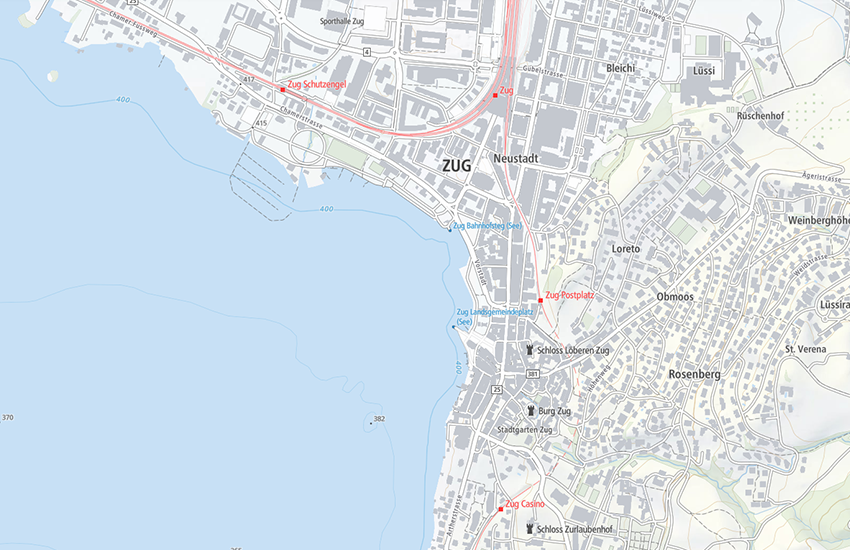
Die «Leichte Basiskarte» ist eine visuell und inhaltlich reduzierte Hintergrundkarte, welche die wichtigsten topographischen Objekte und Namen angepasst an die jeweilige Zoomstufe darstellt. Sie baut auf amtlichen Daten auf: dem topografischen Landschaftsmodell, dem digitalen Höhenmodell, den digitalen kartografischen Modellen, den Haltestellen des öffentlichen Verkehrs und dem amtlichen Verzeichnis der Strassen. Der Inhalt variiert je nach Zoomstufe. Die Vektordarstellung basiert auf der Maplibre Style Spezifikation. Vektorkacheln (Base Vector Tileset, Relief Vector Tileset) bilden die Datengrundlage.
La «Carte de base légère» est une carte de fond au visuel et au contenu réduit et qui affiche les noms et les éléments topographiques les plus importants selon différents niveaux de zoom. Elle est construite sur des données officielles: le modèle topographique du paysage, le modèle altimétrique numérique, les modèles cartographiques numériques, les arrêts de transports publics et le répertoire officiel des rues. La représentation vectorielle est basée sur la spécification Maplibre Style. Les tuiles vectorielles (Base Vector Tileset, Relief Vector Tileset) constituent la base de données.
La «carta di base leggera» è una carta di sfondo visivamente e contenutisticamente ridotta che mostra gli oggetti topografici più importanti e i nomi adattati al rispettivo livello di zoom. Si basa su dati ufficiali: il modello topografico del paesaggio, il modello altimetrico digitale, i modelli cartografici digitali, le fermate dei mezzi di trasporto pubblici e l'elenco ufficiale delle strade. Il contenuto varia a seconda del livello di zoom. La rappresentazione vettoriale è basata sulla specifica Maplibre Style. Le tessere vettoriali (Base Vector Tileset, Relief Vector Tileset) costituiscono la base dei dati.
«Light base map» is a visually and content reduced base map, which represents the most relevant topographic features and names adapted to the respective zoom level. It is constructed on the basis of official data: the topographic landscape model, the digital elevation model, digital cartographic models, public transportation stops and official street registry. The vector representation is based on the Maplibre Style Specification. The data basis consists of vector tiles (Base Vector Tileset and Relief Vector Tileset).
La «charta da basa ligera» è ina charta dal fund reducida visualmain e tematicamain che mussa ils objects ed ils nums topografics ils pli impurtants en ina moda adattada al stgalim da zoom respectiv. Ella sa basa sin datas uffizialas: sin il model topografic da la cuntrada, sin il model digital da l'autezza, sin ils models cartografics digitals, sin las fermadas dal traffic public e sin il register uffizial da las vias. Il cuntegn variescha tut tenor il stgalim da zoom. La preschentaziun vectoriala sa basa sin la specificaziun «Mapbox Style». Quadrels vectorials ((Base Vector Tileset, Relief Vector Tileset) furman la basa da las datas.
Simple
-
Autre titreAltri nomi o acronimiAlternate titleAlternate titleAlternativtitel
-
Light Base Map
Light Base Map
Light Base Map
Light Base Map
Light Base Map
-
Date (Création)Data (Creazione)Date (Creation)Date (Creation)Datum (Erstellung)
- 2019-02-01
-
Date (Révision)Data (Revisione)Date (Revision)Date (Revision)Datum (Aktualisierung)
- 2024-03-01
-
IdentifiantIdentificatoreIdentifierIdentifierKennung
- ch.swisstopo.lightbasemap.vt
-
ÉtatStatoStatusStatusBearbeitungsstatus
-
ContinuIn corsoOn goingOn goingKontinuierliche Aktualisierung
Point de contact
Punto di contatto
Point of contact
Point of contact
Ansprechpartner
Propriétaire
Proprietario
Owner
Owner
Eigentümer
-
Type de représentation spatialeTipo di rappresentazione spazialeSpatial representation typeSpatial representation typeRäumliche Darstellungsart
-
vecteurVettorialeVectorVectorVektor
Résolution spatiale
Risoluzione spaziale
Spatial resolution
Spatial resolution
Räumliche Auflösung
Fraction représentative
Frazione rappresentativa
Equivalent scale
Equivalent scale
Vergleichsmassstab
-
DénominateurDenominatoreDenominatorDenominatorMassstabszahl
- 5000
Résolution spatiale
Risoluzione spaziale
Spatial resolution
Spatial resolution
Räumliche Auflösung
Fraction représentative
Frazione rappresentativa
Equivalent scale
Equivalent scale
Vergleichsmassstab
-
DénominateurDenominatoreDenominatorDenominatorMassstabszahl
- 1000000
-
Catégorie de thèmeCategoria ISOTopic categoryTopic categoryThematik
-
-
A Imagerie, cartes de base et occupation du solA Mappe di base con immagini della copertura terrestreA Imagery base maps earth coverA Imagery base maps earth coverA Oberflächenbeschreibung
-
Étendue
Estensione
Extent
Extent
Ausdehnung
Étendue
Estensione
Extent
Extent
Ausdehnung
-
DescriptionDescrizioneDescriptionDescriptionBeschreibung
-
National map 1:1'000'000
Landeskarte 1:1'000'000
Carte nationale 1:1'000'000
Carta nazionale 1:1'000'000
Landeskarte 1:1'000'000
-
Identifiant géographiqueIdentificatore geograficoGeographic identifierGeographic identifierGeografische Kennung
- NM1000LK1000CN1000CN1000LK1000
))

-
Fréquence de mise à jourFrequenza di aggiornamentoMaintenance and update frequencyMaintenance and update frequencyWartungsintervall
-
Comme nécessaireSecondo necessitàAs neededAs neededBei Bedarf
- geocat.ch
-
-
carte de base
carta di base
base map
-
IFDG l’Infrastructure Fédérale de données géographiques
IFDG Infrastruttura federale dei dati geografici
FSDI Federal Spatial Data Infrastructure
-
géodonnées de base
geodati di base
official geodata
-
opendata.swiss
opendata.swiss
opendata.swiss
opendata.swiss
-
- GEMET - INSPIRE themes, version 1.0
-
-
Dénominations géographiques
Nomi geografici
Geographical names
-
Contraintes sur la ressource
Vincoli sulle risorse
Resource constraints
Resource constraints
Ressourcenbeschränkungen
-
Limitation d'utilisationLimitazione d'usoUse limitationUse limitationNutzungsbeschränkung
-
Es gelten die Nutzungsbedingungen für kostenlose Geodaten und Geodienste (OGD) von swisstopo und die Allgemeinen Nutzungsbedingungen und Betriebsbestimmungen der Bundes Geodaten-Infrastruktur BGDI.
Bei digitalen oder analogen Darstellungen und Publikationen ist die folgende Quellenangabe anzubringen: © swisstopo
Les conditions d'utilisation des géodonnées et géoservices gratuits (OGD) de swisstopo ainsi que les conditions générales d’utilisation et d’exploitation de l’Infrastructure Fédérale de Données Géographiques IFDG s'appliquent.
Les représentations et publications numériques ou analogiques doivent mentionner la source suivante : © swisstopo
Si applicano le condizioni di utilizzo per i geodati e i geoservizi gratuiti (OGD) di swisstopo e le condizioni generali di utilizzo e disposizioni operative dell'infrastruttura federale di dati geografici IFDG.
Le rappresentazioni e le pubblicazioni digitali o analogiche devono contenere il seguente riferimento alla fonte: © swisstopo
The terms of use for free geodata and geoservices (OGD) from swisstopo and the general terms of use and operating regulations of the Federal Spatial Data Infrastructure FSDI apply.
For digital or analogue representations and publications, the following source reference must be included: © swisstopo
-
Contraintes d'utilisationVincoli d'usoUse constraintsUse constraintsNutzungseinschränkungen
-
Autres restrictionsAltre restrizioniOther restrictionsOther restrictionsAndere Beschränkungen
-
Autres contraintesAltri vincoliOther constraintsOther constraintsAndere Einschränkungen
- Nutzungsbedingungen für kostenlose Geodaten und Geodienste (OGD) von swisstopoConditions d'utilisation des géodonnées et géoservices gratuits (OGD) de swisstopoCondizioni di utilizzo per i geodati e i geoservizi gratuiti (OGD) di swisstopoTerms of use for free geodata and geoservices (OGD) from swisstopo
-
Autres contraintesAltri vincoliOther constraintsOther constraintsAndere Einschränkungen
- Allgemeine Nutzungsbedingungen und Betriebsbestimmungen der Bundes Geodaten-Infrastruktur BGDIConditions générales d’utilisation et d’exploitation de l’Infrastructure fédérale de données géographiques IFDGCondizioni generali di utilizzo e disposizioni operative dell’infrastruttura federale di dati geografici (IFDG)General Terms of Use and Operating Conditions of the Federal Spatial Data Infrastructure FSDI
Ressource associée
Risorsa associata
Associated resource
Associated resource
Verlinkte Ressource
-
TitreTitoloTitleTitleTitel
-
Landesvermessung
mensuration nationale
misurazione nazionale
National survey
-
Type d'associationTipo di associazioneAssociation TypeAssociation TypeAssoziationstyp
-
Citation de travail plus largeCitazione di un'opera più ampiaReference to a master resource of which this one is a partReference to a master resource of which this one is a partÜbergeordneter Datenbestand
-
LangueLinguaLanguageLanguageSprache
- English
-
Encodage de caractèresCodifica dei caratteriCharacter encodingCharacter encodingZeichenkodierung
-
Utf8UTF8UTF8UTF8Utf8
-
Informations supplémentairesInformazioni supplementariSupplemental InformationSupplemental InformationZusätzliche Informationen
-
Für Verwaltungseinheiten der zentralen Bundesverwaltung gemäss der Anhang 1 der Regierungs- und Verwaltungsorganisationsverordnung (Anhang 1 RVOV, SR 172.010.1) ist die Light Base Map ebenfalls in weltweiter Ausdehnung verfügbar (Light Base Map World)
Pour des unités administratives de l'administration fédérale centrale, conformément à l'annexe 1 de l'ordonnance sur l'organisation du gouvernement et de l'administration (annexe 1 OLOGA, RS 172.010.1), la Light Base Map est également disponible dans son extension mondiale (Light Base Map World).
Per le unità amministrative dell'Amministrazione federale centrale in conformità all'Allegato 1 dell'Ordinanza sull'organizzazione del governo e dell'amministrazione (Allegato 1 OLOGA, RS 172.010.1), la Light Base Map è disponibile anche in estensione mondiale (Light Base Map World).
For administrative units of the Swiss central federal administration, following specification in Annex 1 of the Government and Administration Organisation Ordinance (Annex 1 RVOV, SR 172.010.1), the Light Base Map is also available in its global version (Light Base Map World).
-
Catégorie de sous-thèmeCategoria di sottotemaSubtopic CategorySubtopic CategoryThematische Unterkategorien
-
A1 Cartes de base, modèles de paysageA1 Mappe di base, modelli paesaggisticiA1 Base Maps, Landscape ModelsA1 Base Maps, Landscape ModelsA1 Basiskarten, Landschaftsmodelle
-
Géodonnées de baseGeodati di baseBasic GeodataBasic GeodataGeobasisdaten
- true
-
Identifiant Géodonnées de baseIdentificativo dei geodati di baseBasic Geodata IDBasic Geodata IDIdentifikator des Geobasisdatensatzes
-
42.17
-
Niveau des géodonnées de baseLivello legale dei geodati di baseBasic Geodata Legal LevelBasic Geodata Legal LevelGeobasisdatenebene
-
FédéralFederaleFederalFederalNational
-
Type de géodonnées de baseTipo di geodati di baseBasic Geodata TypeBasic Geodata TypeGeobasisdatentyp
-
Géodonnées de référenceGeodati di riferimentoReference GeodataReference GeodataGeoreferenzdaten
-
Format de distributionFormato (codifica)Distribution formatDistribution formatAbgabeformat
-
-
JavaScript Object Notation (JSON)
-
Options de transfert numérique
Opzioni di trasferimento digitale
Digital transfer options
Digital transfer options
Optionen für die digitale Übertragung
Options de transfert numérique
Opzioni di trasferimento digitale
Digital transfer options
Digital transfer options
Optionen für die digitale Übertragung
Options de transfert numérique
Opzioni di trasferimento digitale
Digital transfer options
Digital transfer options
Optionen für die digitale Übertragung
-
Ressource en ligneRisorsa onlineOnLine resourceOnLine resourceOnline
-
Download Vector Tile Style
Vector Tile Style für den Perimeter Schweiz
-
Nom du système de référenceNome del sistema di riferimentoReference system identifierReference system identifierName des Referenzsystems
- EPSG:3857
Metadata
-
Identifiant des métadonnéesIdentificativo della schedaMetadata identifierMetadata identifierIdentifikator des Metadatensatzes
- c593018b-0bb2-4b7c-81e7-21071bc47b08
-
LangueLinguaLanguageLanguageSprache
- Deutsch
-
Encodage de caractèresCodifica dei caratteriCharacter encodingCharacter encodingZeichenkodierung
-
Utf8UTF8UTF8UTF8Utf8
-
LangueLinguaLanguageLanguageSprache
- Français
-
Encodage de caractèresCodifica dei caratteriCharacter encodingCharacter encodingZeichenkodierung
-
Utf8UTF8UTF8UTF8Utf8
-
LangueLinguaLanguageLanguageSprache
- Italiano
-
Encodage de caractèresCodifica dei caratteriCharacter encodingCharacter encodingZeichenkodierung
-
Utf8UTF8UTF8UTF8Utf8
-
LangueLinguaLanguageLanguageSprache
- English
-
Encodage de caractèresCodifica dei caratteriCharacter encodingCharacter encodingZeichenkodierung
-
Utf8UTF8UTF8UTF8Utf8
-
LangueLinguaLanguageLanguageSprache
- Rumantsch
-
Encodage de caractèresCodifica dei caratteriCharacter encodingCharacter encodingZeichenkodierung
-
Utf8UTF8UTF8UTF8Utf8
Point de contact
Punto di contatto
Point of contact
Point of contact
Ansprechpartner
-
Heures de serviceOrario di servizioHours of serviceHours of serviceBetriebszeiten
-
08h30 - 11h00 / 14h00 - 16h00 GMT+1
Type de ressource
Tipo di risorsa
Type of resource
Type of resource
Anwendungsbereich der Metadaten
-
Domaine d'application de la ressourceAmbito di applicazione della risorsaResource scopeResource scopeDomäne der Ressourcenanwendung
-
Jeu de donnéesSet di datiDatasetDatasetDatenbestand
-
Lien vers la métadonnéeCollegamento ai metadatiMetadata linkageMetadata linkageLink zu den Metadaten
-
Informations de date (Création)Informazioni sulla data (Creazione)Date info (Creation)Date info (Creation)Datumsangaben (Erstellung)
- 2018-06-21T07:23:17Z
-
Informations de date (Révision)Informazioni sulla data (Revisione)Date info (Revision)Date info (Revision)Datumsangaben (Aktualisierung)
- 2026-04-13T09:43:59.717154Z
Norme des métadonnées
Standard dei metadati
Metadata standard
Metadata standard
Metadatenstandard
-
TitreTitoloTitleTitleTitel
-
eCH-0271