geocat.ch
Geographical UAS zones of Switzerland
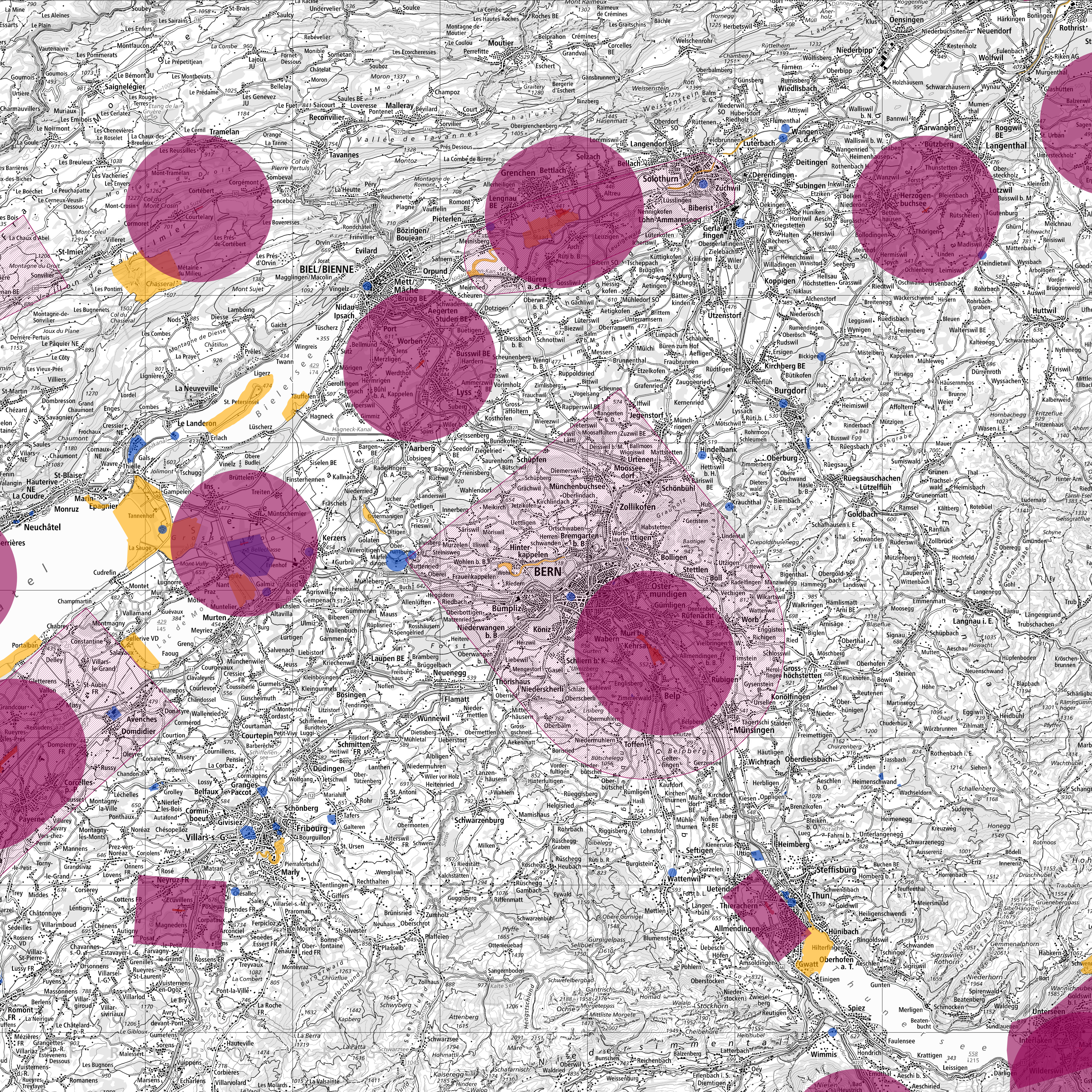
A UAS geographical zone is a portion of airspace designated by the competent authority in which the operation of unmanned aircraft systems (UASs) is permitted, restricted or forbidden in order to take account of the risks to safety, privacy and personal data protection, security or the environment that are associated with UAS operations.
According to Articles 27 and 28 of the DETEC Ordinance on Special Category Aircraft (OSCA), the operation of unmanned aerial vehicles in the defined UAS areas is prohibited. Exceptions may be granted by the competent authorities (Art. 29 OSCA).
Likewise, the cantons may, on the basis of Article 34 OSCA, issue regulations for unmanned aerial vehicles with a weight of less than 25kg to reduce the impact on to the environment and the risk to persons and property on the ground.
Simple
- Alternate title
-
Restrictions for drones
- Date (Creation)
- 2016-09-15T00:00:00
- Date (Revision)
- 2026-06-02T22:05:42.6098746
- Identifier
- ch.bazl.einschraenkungen-drohnen
- Status
- On going
Point of contact
- Spatial representation type
- Vector
Spatial resolution
Equivalent scale
- Denominator
- 5000
Spatial resolution
Equivalent scale
- Denominator
- 1000000
- Topic category
-
- P Transportation
Extent
Extent
- Description
-
Switzerland
))

Extent
Extent
- Description
-
Liechtenstein
))

- Maintenance and update frequency
- As needed
Resource format
- Title
-
INTERLIS 2 (XTF)
- Date
- geocat.ch
-
-
airspace
-
opendata.swiss
-
air navigation
-
- GEMET
-
-
aircraft
-
- geocat.ch
-
-
FSDI Federal Spatial Data Infrastructure
-
Resource constraints
- Use constraints
- Other restrictions
- Other constraints
- Opendata BY: Open use. Must provide the source.
- Other constraints
- Language
- Deutsch
- Character encoding
- UTF8
- Language
- Français
- Character encoding
- UTF8
- Language
- Italiano
- Character encoding
- UTF8
- Language
- English
- Character encoding
- UTF8
- Distribution format
-
-
OGC Geopackage (GPKG)
-
JavaScript Object Notation (JSON)
-
GeoJSON (GEOJSON)
-
ESRI Shapefile (SHP)
-
INTERLIS 2 (XTF)
-
Digital transfer options
- OnLine resource
-
Vorschau map.geo.admin.ch
Preview map.geo.admin.ch
Digital transfer options
- OnLine resource
-
ch.bazl.einschraenkungen-drohnen
WMTS-FSDI service, layer "Restrictions for drones"
Digital transfer options
Digital transfer options
Digital transfer options
Digital transfer options
Digital transfer options
- OnLine resource
-
ch.bazl.einschraenkungen-drohnen
Link to WMS
Digital transfer options
- OnLine resource
-
RESTful API von geo.admin.ch
RESTful API from geo.admin.ch
Digital transfer options
Digital transfer options
Digital transfer options
Digital transfer options
Digital transfer options
- Geometric object type
- Surface
- Reference system identifier
- EPSG:2056
Identifier
- Code
- EPSG:4326
Metadata
- Metadata identifier
- c3ebd7ba-0fd5-411a-9074-3d0cdc46bc4d
- Language
- Deutsch
- Character encoding
- UTF8
- Language
- Français
- Character encoding
- UTF8
- Language
- Italiano
- Character encoding
- UTF8
- Language
- English
- Character encoding
- UTF8
- Language
- Rumantsch
- Character encoding
- UTF8
Point of contact
Type of resource
- Resource scope
- Dataset
- Metadata linkage
-
https://www.geocat.ch/geonetwork/srv/api/records/c3ebd7ba-0fd5-411a-9074-3d0cdc46bc4d
- Date info (Creation)
- 2018-01-22T14:13:01Z
- Date info (Revision)
- 2026-06-02T20:05:42.673099Z
Metadata standard
- Title
-
eCH-0271