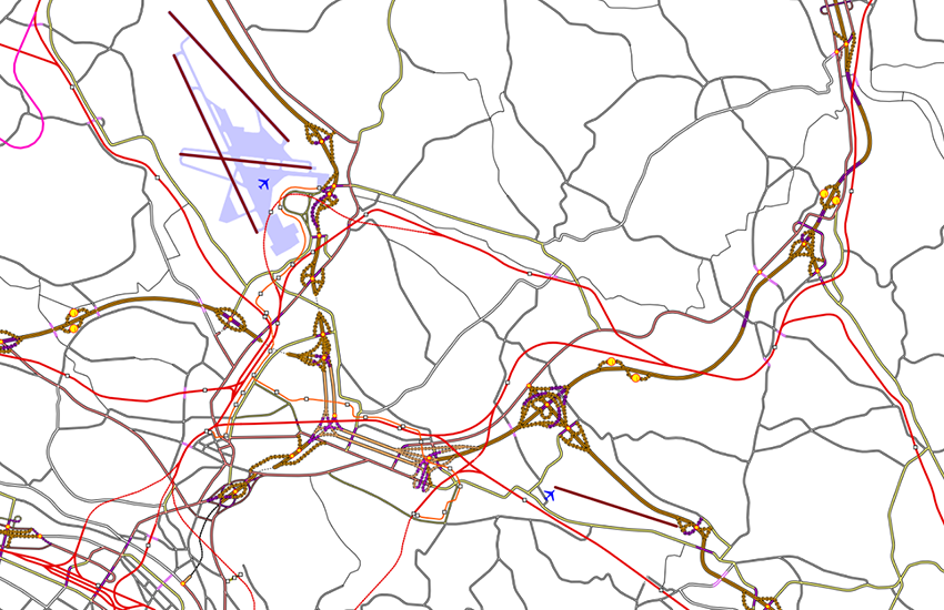
swissTLMRegio Transportation
The topic Transportation contains different features connected with traffic (road, railway, airports, car-ferry, ...). It consists of 12 feature classes and 3 tables. The lines and the points are related to each other according to a so called edge-node structure. Edges (lines) are connected to each other with nodes (points). Every edge has therefore exactly two nodes at its end. Edges and Nodes together build a geometric network. The traffic regulation (prohibition of traffic, one-way streets, no turn) is not described.
Simple
Identification info
- Alternate title
-
Transportation elements swissTLMRegio
- Date (Publication)
- 2012-02-24
- Date (Revision)
- 2025-12-02
- Other citation details
-
Part of the swissTLMRegio dataset
- Collective title
-
Topografisches Landschaftsmodell (Landesvermessung)
- Status
- Completed
Point of contact
Responsible party
- Organisation name
-
Federal Office of Topography swisstopo
- Position name
-
Geodata Distribution
- Voice
-
+41 58 469 01 11
- Facsimile
-
+41 58 469 04 59
Address
- City
-
Wabern
- Postal code
-
3084
- Country
-
CH
- Electronic mail address
- Streetname
-
Seftigenstrasse
- Streetnumber
-
264
- Protocol
-
WWW:LINK
- Role
- Point of contact
- Last Name
-
geodata
- Organisation Acronym
-
swisstopo
- Maintenance and update frequency
- Annually
- Update scope
- Dataset
-
GEMET
-
-
motorway
-
nomenclature
-
railway
-
road network
-
airport
-
railway network
-
geographic information system
-
highway
-
road traffic
-
-
geocat.ch
-
-
path
-
path netwok
-
cableway
-
ferry
-
GIS (Geographic Information System)
-
main road
-
traffic network
-
landscape model
-
-
GEMET themes
-
-
transport
-
-
GEMET - INSPIRE themes, version 1.0
-
-
Geographical names
-
- Use constraints
- License
- Aggregate Datasetindentifier
- 2a190233-498a-46c4-91ca-509a97d797a2
- Association Type
- Larger work citation
- Spatial representation type
- Vector
- Denominator
- 200000
- Language
- English
- Language
- Deutsch
- Character set
- UTF8
- Topic category
-
- A Base Maps, Land Cover, Aerial and Satellite Imagery
- A1 Base Maps, Landscape Models
- P Transportation
Extent
- Description
-
swissTLMRegio
))

- Supplemental Information
- Les topics Transportation, Hydrography, Landcover, Buildings, Miscellaneous, Names et Administrative Boundaries forment ensemble le jeu de données swissTLMRegio. Die Topics Transportation, Hydrography, Landcover, Buildings, Miscellaneous, Names und Administrative Boundaries bilden zusammen den Datensatz swissTLMRegio.
- Basic geodata identifier
-
38.16
- Basic geodata identifier type
- Federal
- Distribution format
-
-
ESRI Personal Geodatabase (Personal-GDB)
(
-
)
-
AutoCAD DXF (DXF)
()
-
ESRI Shapefile (SHP)
()
-
INTERLIS 2 (XTF)
()
-
OGC Geopackage (GPKG)
()
-
ESRI Personal Geodatabase (Personal-GDB)
(
-
)
- OnLine resource
-
swissTLMRegio
(
WWW:LINK
)
swissTLMRegio
- OnLine resource
-
map.geo.admin.ch
(
CHTOPO:specialised-geoportal
)
map.geo.admin.ch
- Hierarchy level
- Dataset
- Statement
-
Based on a 1:200 000 scale. Geometric precision: 20-60 m.
- Topology level
- Full planar graph
- Geometric object type
- Point
- Geometric object count
- 79125
- Geometric object type
- Curve
- Geometric object count
- 114083
- Geometric object type
- Surface
- Geometric object count
- 39
- Reference system identifier
- EPSG:21781
- Reference system identifier
- EPSG:2056
Metadata
- Metadata language
- Deutsch
- Character set
- UTF8
- Hierarchy level
- Tile
- Hierarchy level name
-
Topic
- Date stamp
- 2025-12-15T08:06:15.325Z
- Metadata standard name
-
GM03 2+
Metadata author
Responsible party
- Organisation name
-
Federal Office of Topography swisstopo
- Position name
-
Metadata contact
- Voice
-
+41 58 469 01 11
Address
- City
-
Wabern
- Postal code
-
3084
- Country
-
CH
- Electronic mail address
- Streetname
-
Seftigenstrasse
- Streetnumber
-
264
- Protocol
-
WWW:LINK
- Hours of service
-
08h30 - 11h00 / 14h00 - 16h00 GMT+1
- Role
- Point of contact
- Last Name
-
metadata
- Organisation Acronym
-
swisstopo
- Maintenance and update frequency
- Annually
 geocat.ch


