geocat.ch
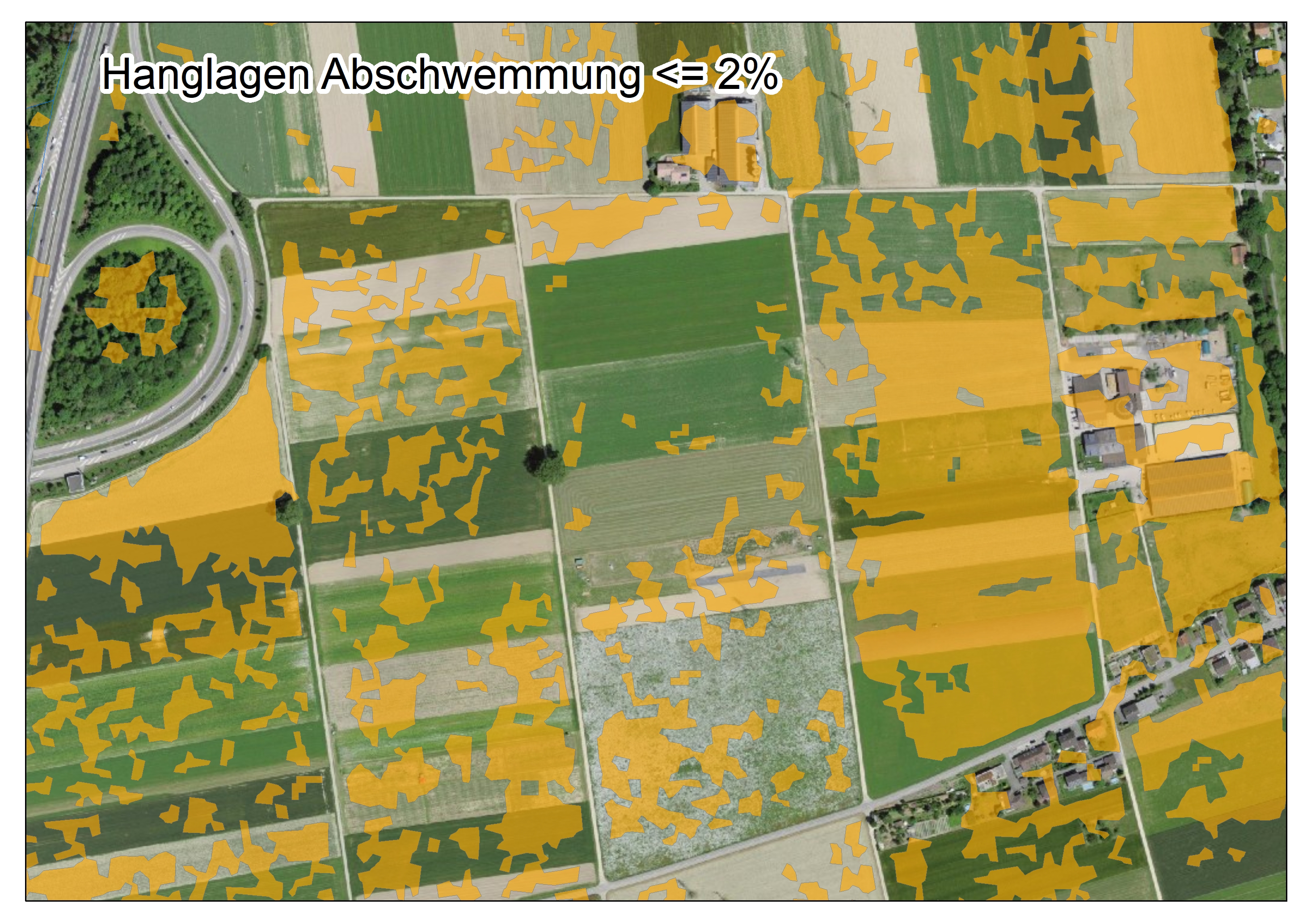
Hanglagen Abschwemmung
Terrains en pente et ruissellement
Zone declive Dilavamento
Der Datensatz Hanglagen Abschwemmung dient dazu, die Flächen zu bestimmen, auf welchen Massnahmen gegen Abschwemmung zu ergreifen sind. Die Massnahmen gegen Abschwemmung richten sich nach dem ÖLN gemäss DZV Anhang 1 Ziffer 6.1a.4 und nach den Weisungen der Zulassungsstelle Pflanzenschutzmittel des Bundesamtes für Lebensmittelsicherheit und Veterinärwese betreffend die Massnahmen zur Reduktion der Risiken bei der Anwendung von Pflanzenschutzmitteln.
Der Datensatz wurde gesamtschweizerisch einheitlich berechnet. Die Produktion beruht auf dem digitalen Höhenmodell DHM25 (Maschenweite 25m) von swisstopo. Folgende Hangneigungsklassen wurden unterschieden: <=2 Prozent; >2 Prozent.
Le jeu de données « Terrains en pente et ruissellement » sert à déterminer les surfaces sur lesquelles des mesures contre le ruissellement doivent être prises. Les prescriptions concernant les mesures contre le ruissellement se fondent sur les PER, conformément à l’annexe 1, ch. 6.1a.4, de l’OPD et aux instructions du service d’homologation des produits phytosanitaires de l’Office fédéral de la sécurité alimentaire et des affaires vétérinaires relatives aux mesures de réduction des risques lors de l’application de produits phytosanitaires.
Ce jeu de données a été élaboré selon une méthode homogène à l’échelle nationale. La production se base sur le modèle numérique d'altitude MNT25 (maille de 25m) de swisstopo. Les classes de pente suivantes ont été distinguées : <=2 pour cent ; >2 pour cent.
Il set di dati «Zone declive Dilavamento» serve per determinare le superfici su cui vanno adottate misure per la riduzione del dilavamento. Le prescrizioni concernenti le misure per la riduzione del dilavamento si basano sulle esigenze relative alla PER secondo l’allegato 1 numero 6.1a.4 OPD e sulle istruzioni del servizio d’omologazione dei prodotti fitosanitari dell’Ufficio federale della sicurezza alimentare e di veterinaria concernenti misure per la riduzione dei rischi nell’utilizzo di prodotti fitosanitari.
I calcoli sono stati effettuati secondo criteri unitari per tutta la Svizzera. La produzione si basa sul modello digitale di elevazione DHM25 (dimensione maglia 25m) di swisstopo. Sono state distinte le seguenti classi di inclinazione del pendio: <=2 per cento; >2 per cento.
Simple
-
Autre titreAltri nomi o acronimiAlternate titleAlternate titleAlternativtitel
-
Hanglagen Abschwemmung
Terrains pente ruissellement
Zone declive Dilavamento
-
Date (Création)Data (Creazione)Date (Creation)Date (Creation)Datum (Erstellung)
- 2023-07-14T00:00:00
-
IdentifiantIdentificatoreIdentifierIdentifierKennung
- ch.blw.hanglagen-abschwemmung
Point de contact
Punto di contatto
Point of contact
Point of contact
Ansprechpartner
-
Heures de serviceOrario di servizioHours of serviceHours of serviceBetriebszeiten
-
8h00-17h00
Propriétaire
Proprietario
Owner
Owner
Eigentümer
-
Type de représentation spatialeTipo di rappresentazione spazialeSpatial representation typeSpatial representation typeRäumliche Darstellungsart
-
vecteurVettorialeVectorVectorVektor
-
Catégorie de thèmeCategoria ISOTopic categoryTopic categoryThematik
-
-
S ÉlevageS AgricolturaS FarmingS FarmingS Landwirtschaft
-
Étendue
Estensione
Extent
Extent
Ausdehnung
Étendue
Estensione
Extent
Extent
Ausdehnung
-
DescriptionDescrizioneDescriptionDescriptionBeschreibung
-
Switzerland
Schweiz
Suisse
Svizzera
Svizra
))

-
Fréquence de mise à jourFrequenza di aggiornamentoMaintenance and update frequencyMaintenance and update frequencyWartungsintervall
-
Comme nécessaireSecondo necessitàAs neededAs neededBei Bedarf
-
Remarque sur la mise à jourNota sull'aggiornamentoMaintenance noteMaintenance noteAnmerkung
-
Le jeu de données est publié chaque année au mois de mai
Datenbestand wird jeweils im Mai jeden Jahres publiziert
-
Durée de conservationDurata di conservazioneDuration of ConservationDuration of ConservationAufbewahrungsdauer NV in Jahren
- 0
-
Évaluation de la valeur archivistiqueValutazione del valore archivisticoAppraisal of Archival ValueAppraisal of Archival ValueBewertung Archivwürdigkeit
-
NNNNN
- geocat.ch
-
-
opendata.swiss
opendata.swiss
opendata.swiss
opendata.swiss
-
- GEMET - INSPIRE themes, version 1.0
-
-
Usage des sols
Utilizzo del territorio
Land use
-
Zones à risque naturel
Zone a rischio naturale
Natural risk zones
-
- geocat.ch
-
-
BGDI Bundesgeodaten-Infrastruktur
IFDG l’Infrastructure Fédérale de données géographiques
IFDG Infrastruttura federale dei dati geografici
FSDI Federal Spatial Data Infrastructure
-
Contraintes sur la ressource
Vincoli sulle risorse
Resource constraints
Resource constraints
Ressourcenbeschränkungen
-
Limitation d'utilisationLimitazione d'usoUse limitationUse limitationNutzungsbeschränkung
-
Auf sämtlichen Plots und Publikationen ist der Vermerk "Hanglagen Abschwemmung Copyright © Bundesamt für Landwirtschaft" anzugeben.
La mention "Terrains en pente et ruissellement Copyright © Office fédéral de l'agriculture" doit figurer sur toutes les cartes et publications.
Contraintes sur la ressource
Vincoli sulle risorse
Resource constraints
Resource constraints
Ressourcenbeschränkungen
-
Contraintes d'utilisationVincoli d'usoUse constraintsUse constraintsNutzungseinschränkungen
-
Autres restrictionsAltre restrizioniOther restrictionsOther restrictionsAndere Beschränkungen
-
Autres contraintesAltri vincoliOther constraintsOther constraintsAndere Einschränkungen
- Opendata BY: Freie Nutzung. Quellenangabe ist Pflicht.Opendata BY: Utilisation libre. Obligation d’indiquer la source.Opendata BY: Libero utilizzo. Indicazione della fonte obbligatoria.Opendata BY: Open use. Must provide the source.
-
LangueLinguaLanguageLanguageSprache
- Deutsch
-
Géodonnées de baseGeodati di baseBasic GeodataBasic GeodataGeobasisdaten
- false
-
Format de distributionFormato (codifica)Distribution formatDistribution formatAbgabeformat
-
-
ESRI Shapefile (SHP)
-
ESRI File Geodatabase FileGDB (GDB)
-
Options de transfert numérique
Opzioni di trasferimento digitale
Digital transfer options
Digital transfer options
Optionen für die digitale Übertragung
Options de transfert numérique
Opzioni di trasferimento digitale
Digital transfer options
Digital transfer options
Optionen für die digitale Übertragung
Options de transfert numérique
Opzioni di trasferimento digitale
Digital transfer options
Digital transfer options
Optionen für die digitale Übertragung
-
Ressource en ligneRisorsa onlineOnLine resourceOnLine resourceOnline
-
ch.blw.hanglagen-abschwemmung
WMS-BGDI Dienst, Layer "Hanglagen Abschwemmung"Service WMS-IFDG, couche "Terrains pente ruissellement"Servizio WMS-IFDG, strato "Zone declive Dilavamento"WMS-FSDI service, layer "Hanglagen Abschwemmung"WMS-BGDI Dienst, Layer "Hanglagen Abschwemmung"
Options de transfert numérique
Opzioni di trasferimento digitale
Digital transfer options
Digital transfer options
Optionen für die digitale Übertragung
-
Ressource en ligneRisorsa onlineOnLine resourceOnLine resourceOnline
-
ch.blw.hanglagen-abschwemmung
WMTS-BGDI Dienst, Layer "Hanglagen Abschwemmung"Service WMTS-IFDG, couche "Terrains pente ruissellement"Servizio WMTS-IFDG, strato "Zone declive Dilavamento"WMTS-FSDI service, layer "-"WMTS-BGDI Dienst, Layer "Hanglagen Abschwemmung"
Options de transfert numérique
Opzioni di trasferimento digitale
Digital transfer options
Digital transfer options
Optionen für die digitale Übertragung
-
Ressource en ligneRisorsa onlineOnLine resourceOnLine resourceOnline
-
Vorschau map.geo.admin.ch
Vorschau map.geo.admin.chAperçu map.geo.admin.chPrevisione map.geo.admin.chPreview map.geo.admin.ch
-
NiveauLivelloHierarchy levelHierarchy levelBezugsebene
-
Jeu de donnéesSet di datiDatasetDatasetDatenbestand
-
DescriptionDescrizioneDescriptionDescriptionBeschreibung
-
Wurde berechnet aus dem Höhenmodell SwissAlti3D 2m
-
Type d’objet géométriqueTipo di oggetto geometricoGeometric object typeGeometric object typeTyp des geometrischen Objekts
-
PolygoneSuperficieSurfaceSurfacesurface
-
Nom du système de référenceNome del sistema di riferimentoReference system identifierReference system identifierName des Referenzsystems
- EPSG:21781
Metadata
-
Identifiant des métadonnéesIdentificativo della schedaMetadata identifierMetadata identifierIdentifikator des Metadatensatzes
- c2ea0f75-f3c7-4d17-87b6-b717b7a57a72
-
LangueLinguaLanguageLanguageSprache
- Deutsch
-
Encodage de caractèresCodifica dei caratteriCharacter encodingCharacter encodingZeichenkodierung
-
Utf8UTF8UTF8UTF8Utf8
-
LangueLinguaLanguageLanguageSprache
- Français
-
Encodage de caractèresCodifica dei caratteriCharacter encodingCharacter encodingZeichenkodierung
-
Utf8UTF8UTF8UTF8Utf8
-
LangueLinguaLanguageLanguageSprache
- Italiano
-
Encodage de caractèresCodifica dei caratteriCharacter encodingCharacter encodingZeichenkodierung
-
Utf8UTF8UTF8UTF8Utf8
-
LangueLinguaLanguageLanguageSprache
- English
-
Encodage de caractèresCodifica dei caratteriCharacter encodingCharacter encodingZeichenkodierung
-
Utf8UTF8UTF8UTF8Utf8
-
LangueLinguaLanguageLanguageSprache
- Rumantsch
-
Encodage de caractèresCodifica dei caratteriCharacter encodingCharacter encodingZeichenkodierung
-
Utf8UTF8UTF8UTF8Utf8
Point de contact
Punto di contatto
Point of contact
Point of contact
Ansprechpartner
-
Heures de serviceOrario di servizioHours of serviceHours of serviceBetriebszeiten
-
8h00-17h00
Type de ressource
Tipo di risorsa
Type of resource
Type of resource
Anwendungsbereich der Metadaten
-
Domaine d'application de la ressourceAmbito di applicazione della risorsaResource scopeResource scopeDomäne der Ressourcenanwendung
-
Jeu de donnéesSet di datiDatasetDatasetDatenbestand
-
Lien vers la métadonnéeCollegamento ai metadatiMetadata linkageMetadata linkageLink zu den Metadaten
-
https://www.geocat.ch/geonetwork/srv/api/records/c2ea0f75-f3c7-4d17-87b6-b717b7a57a72
-
Informations de date (Création)Informazioni sulla data (Creazione)Date info (Creation)Date info (Creation)Datumsangaben (Erstellung)
- 2023-07-11T11:29:06.739Z
-
Informations de date (Révision)Informazioni sulla data (Revisione)Date info (Revision)Date info (Revision)Datumsangaben (Aktualisierung)
- 2026-04-13T09:48:04.876841Z
Norme des métadonnées
Standard dei metadati
Metadata standard
Metadata standard
Metadatenstandard
-
TitreTitoloTitleTitleTitel
-
ISO 19115-3