geocat.ch
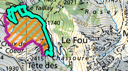
Périmètres forestiers interdits d'accès
Dans le cadre de la protection des forets, les perimetre forestiers interdits definissent des surfaces dans lesquelles les activites listées ne sont pas permises.
Simple
- Alternate title
-
Périmètres forestiers interdits d'accès
- Date (Creation)
- 2023-07-25
- Identifier
- 569
- Purpose
-
Protection des forets
- Status
- On going
Custodian
- Spatial representation type
- Vector
Spatial resolution
Equivalent scale
- Denominator
- 10000
- Topic category
-
- G Biota
- E Planning cadastre
Extent
Extent
- Description
-
Canton of Valais (VS)
))

- Maintenance and update frequency
- Irregular
Resource format
- Title
-
ESRI Enterprise Geodatabase
- Date
- Edition
-
-
- GEMET themes
-
-
tourism
-
- GEMET themes
-
-
natural areas, landscape, ecosystems
-
Resource constraints
- Use limitation
-
aucune
Resource constraints
- Access constraints
- Other restrictions
- Other constraints
-
Géodonnées accessibles au public (niveau A selon l'OGéo)
- Other constraints
-
Les conditions générales d'utilisation des géodonnées du Canton du Valais font foi ( https://www.vs.ch/fr/web/guest/information-legale).
- Language
- Français
- Character encoding
- UTF8
- Language
- Deutsch
- Character encoding
- UTF8
- Environment description
-
S:\Géodonnées VS\G Forêt, flore, faune\Périmètres forestiers interdits d'accès.lyrx
- Subtopic Category
- E1 Spatial Planning, Spatial Development
- Title
-
Catalogue d'objets
- Date (Creation)
- 2023-11-08
- Distribution format
-
-
ESRI Shapefile (SHP)
-
autres formats sur demande / andere Formate auf Anfrage
-
ArcGIS REST Feature Service
-
Distributor
Digital transfer options
- OnLine resource
-
Géoportail du Canton du Valais
Géoportail du Canton du Valais
Digital transfer options
- OnLine resource
-
perimetre_interdit
Dans le cadre de la protection des forets, les perimetre forestiers interdits definissent des surfaces dans lesquelles les activites listées ne sont pas permises.
- Statement
-
Donnees numérisées sur la base de plan
- Hierarchy level
- Dataset
- Description
-
numerisation
- Geometric object type
- Surface
- Geometric object count
- 3
- Geometric object type
- Curve
- Geometric object count
- 6
- Reference system identifier
- EPSG:2056/CH1903+_MN95
Metadata
- Metadata identifier
- c0e8971d-3faa-4636-b40d-52142770d5cb
- Language
- Français
- Character encoding
- UTF8
- Language
- Deutsch
- Character encoding
- UTF8
- Language
- Italiano
- Character encoding
- UTF8
- Language
- English
- Character encoding
- UTF8
- Language
- Rumantsch
- Character encoding
- UTF8
Distributor
Type of resource
- Resource scope
- Dataset
- Metadata linkage
-
https://www.geocat.ch/geonetwork/srv/api/records/c0e8971d-3faa-4636-b40d-52142770d5cb
- Date info (Creation)
- 2023-10-26T08:21:26.014Z
- Date info (Revision)
- 2026-04-13T09:29:47.428307Z
Metadata standard
- Title
-
eCH-0271