 geocat.ch
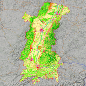
Corine Land Cover - Land cover in the upper rhine region
Upper Rhine land cover - 2018
Simple
- Alternate title
-
CLC 2018
- Date (Creation)
- 2019-04-26
- Date (Publication)
- 2021-11-03
- Date (Revision)
- 2021-11-03
- Identifier
- CLC_2018_CRS_ORK
- Status
- Completed
Point of contact
- mri:deliveryPoint
-
100, avenue d'Alsace
- mri:city
-
COLMAR
- mri:postalCode
-
68000
- Country
-
FRANCE
- Spatial representation type
- Vector
Spatial resolution
Equivalent scale
- Denominator
- 100000
- Topic category
-
- A Imagery base maps earth cover
Extent
Extent
Temporal extent
- Time period
- 2018-01-01 2018-12-31
Extent
Extent
N
S
E
W
))
- Maintenance and update frequency
- Not planned
- Keywords
-
-
Open-Data
-
- Place
-
-
Upper Rhine
-
- GEMET - Concepts, version 2.4
-
-
land occupation
-
Resource constraints
- Use limitation
-
Free, full and open access to this data - © European Union, Copernicus Land Monitoring Service 2018, European Environment Agency (EEA)
Resource constraints
- Access constraints
- Other restrictions
- Use constraints
- Other restrictions
- Other constraints
-
No other limitation
- Language
- English
- Character encoding
- UTF8
- Distribution format
-
-
SHP GeoData
-
Digital transfer options
- OnLine resource
-
occupation_sol_2018
Corine Land Cover 2018 sur le territoire de la conférence du Rhin Supérieur
Digital transfer options
- OnLine resource
-
basemaps:occupation_sol_2018
Corine Land Cover 2018 sur le territoire de la conférence du Rhin Supérieur
Digital transfer options
- OnLine resource
-
Téléchargement du Shapefile Téléchargement du Shapefile
- Statement
-
OSM + GeoRhena
- Hierarchy level
- Dataset
Metadata
- Metadata identifier
- c0ccbf45-2620-4bde-93f8-869558e51d7e
- Language
- Français
- Character encoding
- UTF8
- Language
- Deutsch
- Character encoding
- UTF8
- Language
- English
- Character encoding
- UTF8
Contact
- mdb:deliveryPoint
-
100, avenue d'Alsace
- mdb:city
-
COLMAR
- mdb:postalCode
-
68000
- mdb:country
-
FR
Type of resource
- Resource scope
- Dataset
- Date info (Revision)
- 2022-10-03T15:42:24.258107Z
Metadata standard
- Title
-
ISO 19115-3:2018
- Edition
-
1.0
)))