geocat.ch
SWISSIMAGE HIST 1946: La mosaïque d'orthophotos historiques de la Suisse de 1946
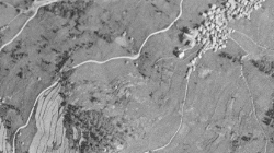
La mosaïque d'orthophotos SWISSIMAGE HIST 1946 est un assemblage des images aériennes historiques en noir et blanc datant de 1946(«survol des Américains») sur l'ensemble de la Suisse avec une résolution au sol de 1 m, n/b
Simple
- Alternate title
-
SwissImage HIST 1946 (VS)
- Date (Creation)
- 2019-03-01
- Identifier
- 529
- Purpose
-
Les images constituent, pour le grand public et pour la recherche, une base idéale pour observer les changements énormes et rapides du paysage suisse.
- Status
- Historical archive
Custodian
- Spatial representation type
- Grid
Spatial resolution
- Spatial resolution
- 1 m
- Topic category
-
- A Imagery base maps earth cover
Extent
Extent
- Description
-
Canton of Valais (VS)
))

- Maintenance and update frequency
- Not planned
Resource format
- Title
-
Tagged Image File Format (TIFF)
- Date
- GEMET - INSPIRE themes, version 1.0
-
-
Orthoimagery
-
- GEMET
-
-
mosaic
-
aerial photograph
-
- geocat.ch
-
-
orthophoto
-
raster data
-
official geodata
-
historic map
-
Resource constraints
- Use limitation
-
sous licence
Resource constraints
- Access constraints
- Other restrictions
- Other constraints
-
sous licence
- Other constraints
-
Les conditions générales d'utilisation des géodonnées du Canton du Valais font foi ( https://www.vs.ch/fr/web/guest/information-legale).
- Language
- Français
- Character encoding
- UTF8
- Language
- Deutsch
- Character encoding
- UTF8
- Environment description
-
S:\Géodonnées VS\A3 Images\SwissImage HIST 1946.lyr
- Subtopic Category
- A3 Aerial and Satellite Imagery
- Basic Geodata
- true
- Basic Geodata ID
-
35
- Basic Geodata Legal Level
- Federal
- Basic Geodata Type
- Reference Geodata
- Distribution format
-
-
GeoTIFF (GEOTIFF)
-
Cloud Optimized GeoTIFF (TIFF / TIF)
-
Distributor
- Statement
-
Photos aériennes
- Hierarchy level
- Dataset
- Description
-
4033 des 4117 images numérisées purent être orientées en utilisant la comparaison automatique d’image (bildmatching). Pour les 2 % restants, cela n’a pas été possible en raison de marques de repérage pas entièrement mesurables, de dommages trop importants à l’image ou d’une couverture nuageuse trop grande. Les images aériennes ont ensuite été traitées en orthophotos avec une résolution au sol de 1 m et en utilisant le modèle de terrain actuel swissALTI 3D. Le mosaïquage s’est fait en grande partie automatiquement.
- Reference system identifier
- EPSG:2056/CH1903+_MN95
Metadata
- Metadata identifier
- c00c36dd-1772-4c37-8335-2256d6aabc37
- Language
- Français
- Character encoding
- UTF8
- Language
- Deutsch
- Character encoding
- UTF8
- Language
- Italiano
- Character encoding
- UTF8
- Language
- English
- Character encoding
- UTF8
- Language
- Rumantsch
- Character encoding
- UTF8
Distributor
Type of resource
- Resource scope
- Dataset
- Metadata linkage
-
https://www.geocat.ch/geonetwork/srv/api/records/c00c36dd-1772-4c37-8335-2256d6aabc37
- Date info (Creation)
- 2020-03-02T10:48:32Z
- Date info (Revision)
- 2026-05-18T12:05:36.612566Z
Metadata standard
- Title
-
eCH-0271