geocat.ch
Blatteinteilung der Dufourkarte
Découpage de la Carte Dufour
Divisione della Carta Dufour
Sheet Division of the Dufour Map
Divisiun da la Charta Dufour
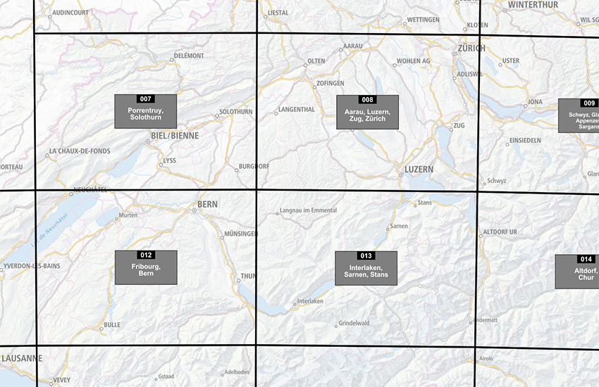
Die Topographische Karte der Schweiz 1:100 000 (Dufourkarte) ist das erste amtliche Kartenwerk, das die Schweiz landesweit abdeckt. Sie wurde zwischen 1845 und 1865 publiziert und bis 1939 nachgeführt. Der Datensatz «Blatteinteilung der Dufourkarte» zeigt den Perimeter, die Nummer und den Namen jedes Kartenblattes. Die Blätter mit Ausbuchtungen auf den gedruckten Ausgaben werden mit einer etwas grösseren Fläche als bei den Standardblättern dargestellt. Das Titelblatt und die Karten Fort de l'Ecluse, Rheineck und Bergamo werden zusammen mit einer Nachbarkarte dargestellt.
La carte topographique de la Suisse 1 :100 000 (Carte Dufour) est la première série de cartes officielles de la Suisse. Elle a été publiée entre les années 1845 et 1865 avec des mises à jour effectuées jusqu’à 1939. Le jeu de données "Découpage de la Carte Dufour" comprend le périmètre, le numéro et le nom de chaque feuille. Les feuilles dont l’édition papier comporte des ajouts sont représentées par des surfaces légèrement plus grandes que les feuilles standards. La feuille de titre ainsi que les cartes Fort de l'Ecluse, Rheineck et Bergamo ont été accolées à une feuille voisine.
La carta topografica della Svizzera 1:100 000 (Carta Dufour) è la prima opera cartografica della Svizzera. Essa fu pubblicata tra il 1845 e il 1865 e aggiornata fino al 1939. Il set di dati “Divisione della Carta Dufour”, comprende il perimetro, il numero e il nome di ogni foglio. I fogli, cui l’edizione cartacea comporta delle aggiunte, sono rappresentanti da superfici leggermente più grandi che i fogli standard. Il foglio di titolo cosi come le carte Fort de l'Ecluse, Rheineck e Bergamo sono state aggiunte.
The Topographical Map 1:100 000 (Dufour Map) is the first modern official map series of Switzerland. It was produced between 1845 and 1865 with revisions up to 1939. The dataset "Sheet Division of the Dufour Map" shows the perimeter, number and name of each sheet of the map 1:25 000. The sheets with protruding areas on the printed maps are shown by bigger areas than a standard map. The title sheet and the map sheets Fort de l'Ecluse, Rheineck and Bergamo have been merged with a neighbouring map sheet.
La Charta topografica da la Svizra 1:100'000 (Charta Dufour) è l'emprima ovra cartografica uffiziala che cuvra l'entira Svizra. Ella è vegnida publitgada tranter 1845 e 1865 ed è vegnida actualisada fin l'onn 1939. L'unitad da datas «Divisiun Charta Dufour» mussa il perimeter, il numer ed il num da mintga fegl. Ils fegls stampads cun las parts extendidas vegnan preschentads cun surfatschas in pau pli grondas ch'ils fegls da standard. Il frontispizi e las chartas Fort de l'Ecluse, Rheineck e Bergamo vegnan preschentads ensemen cun ina charta vischina.
Simple
-
Autre titreAltri nomi o acronimiAlternate titleAlternate titleAlternativtitel
-
Einteilung Dufourkarte Raster
Découpage carte Dufour Raster
Divisione carta Dufour Raster
Division Dufour Map Raster
Divisiun Charta Dufour Raster
-
Date (Publication)Data (Pubblicazione)Date (Publication)Date (Publication)Datum (Publikation)
- 1865-12-31
-
IdentifiantIdentificatoreIdentifierIdentifierKennung
- ch.swisstopo.hiks-dufour.metadata
Propriétaire
Proprietario
Owner
Owner
Eigentümer
Résolution spatiale
Risoluzione spaziale
Spatial resolution
Spatial resolution
Räumliche Auflösung
Fraction représentative
Frazione rappresentativa
Equivalent scale
Equivalent scale
Vergleichsmassstab
-
DénominateurDenominatoreDenominatorDenominatorMassstabszahl
- 25000
-
Catégorie de thèmeCategoria ISOTopic categoryTopic categoryThematik
-
-
A Imagerie, cartes de base et occupation du solA Mappe di base con immagini della copertura terrestreA Imagery base maps earth coverA Imagery base maps earth coverA Oberflächenbeschreibung
-
Étendue
Estensione
Extent
Extent
Ausdehnung
Étendue
Estensione
Extent
Extent
Ausdehnung
-
DescriptionDescrizioneDescriptionDescriptionBeschreibung
-
Switzerland
Schweiz
Suisse
Svizzera
Svizra
))

Étendue
Estensione
Extent
Extent
Ausdehnung
Étendue
Estensione
Extent
Extent
Ausdehnung
-
DescriptionDescrizioneDescriptionDescriptionBeschreibung
-
Dufour Map
Dufourkarte
Carte Dufour
Carta Dufour
-
Identifiant géographiqueIdentificatore geograficoGeographic identifierGeographic identifierGeografische Kennung
- TMTKCTCTnull
))

-
Fréquence de mise à jourFrequenza di aggiornamentoMaintenance and update frequencyMaintenance and update frequencyWartungsintervall
-
InconnueSconosciutoUnknownUnknownUnbekannt
- geocat.ch
-
-
BGDI Bundesgeodaten-Infrastruktur
IFDG l’Infrastructure Fédérale de données géographiques
IFDG Infrastruttura federale dei dati geografici
FSDI Federal Spatial Data Infrastructure
-
Contraintes sur la ressource
Vincoli sulle risorse
Resource constraints
Resource constraints
Ressourcenbeschränkungen
-
Contraintes d'utilisationVincoli d'usoUse constraintsUse constraintsNutzungseinschränkungen
-
Autres restrictionsAltre restrizioniOther restrictionsOther restrictionsAndere Beschränkungen
-
Autres contraintesAltri vincoliOther constraintsOther constraintsAndere Einschränkungen
-
-- URL Nutzungsbedingungen (s. Handbuch)
Contraintes sur la ressource
Vincoli sulle risorse
Resource constraints
Resource constraints
Ressourcenbeschränkungen
-
Limitation d'utilisationLimitazione d'usoUse limitationUse limitationNutzungsbeschränkung
-
-- gebührenpflichtig --
Ressource associée
Risorsa associata
Associated resource
Associated resource
Verlinkte Ressource
-
Type d'associationTipo di associazioneAssociation TypeAssociation TypeAssoziationstyp
-
Description deÈ una descrizione diResource is a description of associated resourceResource is a description of associated resourceIst Beschreibung von
-
Metadata ReferenceRiferimento metadatiMetadata ReferenceMetadata ReferenceMetadatenreferenz
Ressource associée
Risorsa associata
Associated resource
Associated resource
Verlinkte Ressource
-
TitreTitoloTitleTitleTitel
-
Historische Karten
Cartes historiques
Carte storiche
Historical maps
-
Type d'associationTipo di associazioneAssociation TypeAssociation TypeAssoziationstyp
-
Citation de travail plus largeCitazione di un'opera più ampiaReference to a master resource of which this one is a partReference to a master resource of which this one is a partÜbergeordneter Datenbestand
-
LangueLinguaLanguageLanguageSprache
- Deutsch
-
Encodage de caractèresCodifica dei caratteriCharacter encodingCharacter encodingZeichenkodierung
-
Utf8UTF8UTF8UTF8Utf8
-
Catégorie de sous-thèmeCategoria di sottotemaSubtopic CategorySubtopic CategoryThematische Unterkategorien
-
A1 Cartes de base, modèles de paysageA1 Mappe di base, modelli paesaggisticiA1 Base Maps, Landscape ModelsA1 Base Maps, Landscape ModelsA1 Basiskarten, Landschaftsmodelle
-
Format de distributionFormato (codifica)Distribution formatDistribution formatAbgabeformat
-
-
ESRI Shapefile (SHP)
-
Options de transfert numérique
Opzioni di trasferimento digitale
Digital transfer options
Digital transfer options
Optionen für die digitale Übertragung
-
Ressource en ligneRisorsa onlineOnLine resourceOnLine resourceOnline
-
Vorschau map.geo.admin.ch
Vorschau map.geo.admin.chAperçu map.geo.admin.chPrevisione map.geo.admin.chPreview map.geo.admin.ch
Options de transfert numérique
Opzioni di trasferimento digitale
Digital transfer options
Digital transfer options
Optionen für die digitale Übertragung
-
Ressource en ligneRisorsa onlineOnLine resourceOnLine resourceOnline
-
ch.swisstopo.hiks-dufour.metadata
WMS-BGDI Dienst, Layer "Einteilung Dufourkarte Raster"Service WMS-IFDG, couche "Découpage carte Dufour Raster"Servizio WMS-IFDG, strato "Divisione carta Dufour Raster"WMS-FSDI service, layer "Division Dufour Map Raster"WMS-BGDI Dienst, Layer "Einteilung Dufourkarte Raster"
Options de transfert numérique
Opzioni di trasferimento digitale
Digital transfer options
Digital transfer options
Optionen für die digitale Übertragung
-
Ressource en ligneRisorsa onlineOnLine resourceOnLine resourceOnline
-
Shop
Options de transfert numérique
Opzioni di trasferimento digitale
Digital transfer options
Digital transfer options
Optionen für die digitale Übertragung
-
Ressource en ligneRisorsa onlineOnLine resourceOnLine resourceOnline
-
Carte Dufour digitale
Options de transfert numérique
Opzioni di trasferimento digitale
Digital transfer options
Digital transfer options
Optionen für die digitale Übertragung
-
Ressource en ligneRisorsa onlineOnLine resourceOnLine resourceOnline
-
map.geo.admin.ch
Options de transfert numérique
Opzioni di trasferimento digitale
Digital transfer options
Digital transfer options
Optionen für die digitale Übertragung
-
Ressource en ligneRisorsa onlineOnLine resourceOnLine resourceOnline
-
RESTful API von geo.admin.ch
RESTful API von geo.admin.chRESTful API de geo.admin.chRESTful API da geo.admin.chRESTful API from geo.admin.chRESTful API dad geo.admin.ch
-
Type d’objet géométriqueTipo di oggetto geometricoGeometric object typeGeometric object typeTyp des geometrischen Objekts
-
PolygoneSuperficieSurfaceSurfacesurface
-
Nom du système de référenceNome del sistema di riferimentoReference system identifierReference system identifierName des Referenzsystems
- EPSG:21781
Metadata
-
Identifiant des métadonnéesIdentificativo della schedaMetadata identifierMetadata identifierIdentifikator des Metadatensatzes
- bfa9994f-c8b1-4dc1-90b2-fe1211bf2d22
-
LangueLinguaLanguageLanguageSprache
- Deutsch
-
Encodage de caractèresCodifica dei caratteriCharacter encodingCharacter encodingZeichenkodierung
-
Utf8UTF8UTF8UTF8Utf8
-
LangueLinguaLanguageLanguageSprache
- Français
-
Encodage de caractèresCodifica dei caratteriCharacter encodingCharacter encodingZeichenkodierung
-
Utf8UTF8UTF8UTF8Utf8
-
LangueLinguaLanguageLanguageSprache
- Italiano
-
Encodage de caractèresCodifica dei caratteriCharacter encodingCharacter encodingZeichenkodierung
-
Utf8UTF8UTF8UTF8Utf8
-
LangueLinguaLanguageLanguageSprache
- English
-
Encodage de caractèresCodifica dei caratteriCharacter encodingCharacter encodingZeichenkodierung
-
Utf8UTF8UTF8UTF8Utf8
-
LangueLinguaLanguageLanguageSprache
- Rumantsch
-
Encodage de caractèresCodifica dei caratteriCharacter encodingCharacter encodingZeichenkodierung
-
Utf8UTF8UTF8UTF8Utf8
Dépositaire
Custode
Custodian
Custodian
Verwalter
-
Heures de serviceOrario di servizioHours of serviceHours of serviceBetriebszeiten
-
08h30 - 11h00 / 14h00 - 16h00 GMT+1
Type de ressource
Tipo di risorsa
Type of resource
Type of resource
Anwendungsbereich der Metadaten
-
Domaine d'application de la ressourceAmbito di applicazione della risorsaResource scopeResource scopeDomäne der Ressourcenanwendung
-
Jeu de donnéesSet di datiDatasetDatasetDatenbestand
-
Lien vers la métadonnéeCollegamento ai metadatiMetadata linkageMetadata linkageLink zu den Metadaten
-
Informations de date (Création)Informazioni sulla data (Creazione)Date info (Creation)Date info (Creation)Datumsangaben (Erstellung)
- 2016-04-27T14:27:52Z
-
Informations de date (Révision)Informazioni sulla data (Revisione)Date info (Revision)Date info (Revision)Datumsangaben (Aktualisierung)
- 2026-06-15T07:24:01.120402Z
Norme des métadonnées
Standard dei metadati
Metadata standard
Metadata standard
Metadatenstandard
-
TitreTitoloTitleTitleTitel
-
eCH-0271