geocat.ch
swissSURFACE3D Raster, das digitale Oberflächenmodell der Schweiz
swissSURFACE3D Raster, le modèle numérique de surface de la Suiss
swissSURFACE3D Raster, il modello digitale della superficie della Svizzera
swissSURFACE3D Raster, the digital surface model of Switzerland
swissSURFACE3D Raster
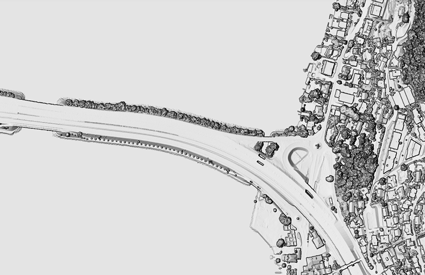
swissSURFACE3D Raster ist ein digitales Oberflächenmodell (DOM) welches die Form der Erdoberfläche abbildet, wobei alle beständigen und sichtbaren Landschaftselemente wie Boden, Bewuchs, Wälder, Hochbauten und weitere Kunstbauten einbezogen werden. swissSURFACE3D Raster wird in Kacheln von jeweils 1 km2 produziert. Die Kachelnummerierung entspricht den Kilometerkoordinaten des südwestlichen Eckpunkts einer Kachel.
swissSURFACE3D Raster est un modèle numérique de surface (MNS) qui reproduit la forme de la surface terrestre en incluant tous les éléments permanents et visibles du paysage tels que le sol, la végétation, les forêts, les bâtiments et les autres ouvrages d’art. swissSURFACE3D Raster est produit en tuiles de 1 km2. La numérotation des tuiles correspond aux coordonnées kilométriques de leur angle sud-ouest.
swissSURFACE 3D Raster è un modello digitale della superficie (MDS) che riproduce la forma della superficie terrestre tenendo conto di tutti gli elementi permanenti e visibili del paesaggio, quali il terreno, la vegetazione, le foreste, gli edifici ed altre opere artificiali.
swissSURFACE3D Raster viene prodotto in tasselli di 1 km2. La loro numerazione corrisponde alle coordinate chilometriche del loro angolo sud-ovest.
swissSURFACE3D Raster is a digital surface model (DSM) which represents the earth's surface including all stable and visible landscape elements such as soil, natural cover, woods and all sorts of constructive works. swissSURFACE3D Raster is produced in 1 km2 tiles. The tiles are numbered based on the coordinates in kilometers of their southwestern corner.
Simple
-
Autre titreAltri nomi o acronimiAlternate titleAlternate titleAlternativtitel
-
swissSURFACE3D Raster
swissSURFACE3D Raster
swissSURFACE3D Raster
swissSURFACE3D Raster
swissSURFACE3D Raster
-
Date (Création)Data (Creazione)Date (Creation)Date (Creation)Datum (Erstellung)
- 2019-02-06
-
IdentifiantIdentificatoreIdentifierIdentifierKennung
- ch.swisstopo.swisssurface3d-raster
Propriétaire
Proprietario
Owner
Owner
Eigentümer
-
Catégorie de thèmeCategoria ISOTopic categoryTopic categoryThematik
-
-
C ÉlévationC AltitudineC ElevationC ElevationC Höhenangaben
-
Étendue
Estensione
Extent
Extent
Ausdehnung
Étendue
Estensione
Extent
Extent
Ausdehnung
-
DescriptionDescrizioneDescriptionDescriptionBeschreibung
-
SWISSIMAGE 10 cm
SWISSIMAGE 10 cm
SWISSIMAGE 10 cm
SWISSIMAGE 10 cm
SWISSIMAGE 10 cm
-
Identifiant géographiqueIdentificatore geograficoGeographic identifierGeographic identifierGeografische Kennung
- SWISSIMAGE 10 cmSWISSIMAGE 10 cmSWISSIMAGE 10 cmSWISSIMAGE 10 cmSWISSIMAGE 10 cm
))

-
Fréquence de mise à jourFrequenza di aggiornamentoMaintenance and update frequencyMaintenance and update frequencyWartungsintervall
-
InconnueSconosciutoUnknownUnknownUnbekannt
- GEMET
-
-
relief
rilievo
relief (land)
-
laser
laser (radiazione)
laser
-
végétation
vegetazione
vegetation
-
altitude
altitudine
altitude
-
- GEMET - INSPIRE themes, version 1.0
-
-
Altitude
Elevazione
Elevation
-
- geocat.ch
-
-
LIDAR (Light Detection And Ranging)
LIDAR (Light Detection And Ranging)
LIDAR (Light Detection And Ranging)
-
données raster
dati raster
raster data
-
Airborne-Laser-Scanning
Airborne-Laser-Scanning
Airborne-Laser-Scanning
-
opendata.swiss
opendata.swiss
opendata.swiss
opendata.swiss
-
IFDG l’Infrastructure Fédérale de données géographiques
IFDG Infrastruttura federale dei dati geografici
FSDI Federal Spatial Data Infrastructure
-
Contraintes sur la ressource
Vincoli sulle risorse
Resource constraints
Resource constraints
Ressourcenbeschränkungen
-
Contraintes d'utilisationVincoli d'usoUse constraintsUse constraintsNutzungseinschränkungen
-
Autres restrictionsAltre restrizioniOther restrictionsOther restrictionsAndere Beschränkungen
-
Autres contraintesAltri vincoliOther constraintsOther constraintsAndere Einschränkungen
- Opendata BY: Freie Nutzung. Quellenangabe ist Pflicht.Opendata BY: Utilisation libre. Obligation d’indiquer la source.Opendata BY: Libero utilizzo. Indicazione della fonte obbligatoria.Opendata BY: Open use. Must provide the source.
Ressource associée
Risorsa associata
Associated resource
Associated resource
Verlinkte Ressource
-
Type d'associationTipo di associazioneAssociation TypeAssociation TypeAssoziationstyp
-
Citation de travail plus largeCitazione di un'opera più ampiaReference to a master resource of which this one is a partReference to a master resource of which this one is a partÜbergeordneter Datenbestand
-
Metadata ReferenceRiferimento metadatiMetadata ReferenceMetadata ReferenceMetadatenreferenz
-
LangueLinguaLanguageLanguageSprache
- Deutsch
-
Encodage de caractèresCodifica dei caratteriCharacter encodingCharacter encodingZeichenkodierung
-
Utf8UTF8UTF8UTF8Utf8
-
Géodonnées de baseGeodati di baseBasic GeodataBasic GeodataGeobasisdaten
- true
-
Identifiant Géodonnées de baseIdentificativo dei geodati di baseBasic Geodata IDBasic Geodata IDIdentifikator des Geobasisdatensatzes
-
41.7
-
Niveau des géodonnées de baseLivello legale dei geodati di baseBasic Geodata Legal LevelBasic Geodata Legal LevelGeobasisdatenebene
-
FédéralFederaleFederalFederalNational
-
Format de distributionFormato (codifica)Distribution formatDistribution formatAbgabeformat
-
-
GeoTIFF (GEOTIFF)
-
GRID ASCII (XYZ)
-
Options de transfert numérique
Opzioni di trasferimento digitale
Digital transfer options
Digital transfer options
Optionen für die digitale Übertragung
Options de transfert numérique
Opzioni di trasferimento digitale
Digital transfer options
Digital transfer options
Optionen für die digitale Übertragung
-
Nombre de dimensionsNumero di dimensioniNumber of dimensionsNumber of dimensionsAnzahl der Dimensionen
- 25
-
Géométrie de la celluleGeometria della cellaCell geometryCell geometryZellgeometrie
-
SurfaceAreaAreaAreaFläche
-
Disponibilité des paramètres de transformationDisponibilità dei parametri di trasformazioneTransformation parameter availabilityTransformation parameter availabilityVerfügbarkeit der Transformationsparameter
- true
-
Nom du système de référenceNome del sistema di riferimentoReference system identifierReference system identifierName des Referenzsystems
- EPSG:2056
Metadata
-
Identifiant des métadonnéesIdentificativo della schedaMetadata identifierMetadata identifierIdentifikator des Metadatensatzes
- bd4f6bf2-6622-4a16-a6c8-37326ebc9012
-
LangueLinguaLanguageLanguageSprache
- Deutsch
-
Encodage de caractèresCodifica dei caratteriCharacter encodingCharacter encodingZeichenkodierung
-
Utf8UTF8UTF8UTF8Utf8
-
LangueLinguaLanguageLanguageSprache
- Français
-
Encodage de caractèresCodifica dei caratteriCharacter encodingCharacter encodingZeichenkodierung
-
Utf8UTF8UTF8UTF8Utf8
-
LangueLinguaLanguageLanguageSprache
- Italiano
-
Encodage de caractèresCodifica dei caratteriCharacter encodingCharacter encodingZeichenkodierung
-
Utf8UTF8UTF8UTF8Utf8
-
LangueLinguaLanguageLanguageSprache
- English
-
Encodage de caractèresCodifica dei caratteriCharacter encodingCharacter encodingZeichenkodierung
-
Utf8UTF8UTF8UTF8Utf8
-
LangueLinguaLanguageLanguageSprache
- Rumantsch
-
Encodage de caractèresCodifica dei caratteriCharacter encodingCharacter encodingZeichenkodierung
-
Utf8UTF8UTF8UTF8Utf8
Dépositaire
Custode
Custodian
Custodian
Verwalter
-
Heures de serviceOrario di servizioHours of serviceHours of serviceBetriebszeiten
-
08h30 - 11h00 / 14h00 - 16h00 GMT+1
Type de ressource
Tipo di risorsa
Type of resource
Type of resource
Anwendungsbereich der Metadaten
-
Domaine d'application de la ressourceAmbito di applicazione della risorsaResource scopeResource scopeDomäne der Ressourcenanwendung
-
Jeu de donnéesSet di datiDatasetDatasetDatenbestand
-
Lien vers la métadonnéeCollegamento ai metadatiMetadata linkageMetadata linkageLink zu den Metadaten
-
Informations de date (Création)Informazioni sulla data (Creazione)Date info (Creation)Date info (Creation)Datumsangaben (Erstellung)
- 2020-12-16T10:21:02Z
-
Informations de date (Révision)Informazioni sulla data (Revisione)Date info (Revision)Date info (Revision)Datumsangaben (Aktualisierung)
- 2026-06-15T09:17:46.927375Z
Norme des métadonnées
Standard dei metadati
Metadata standard
Metadata standard
Metadatenstandard
-
TitreTitoloTitleTitleTitel
-
eCH-0271