 geocat.ch
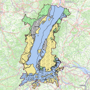
Hydrogeology: Upper Rhine aquifer
Location of the Upper Rhine aquifers according to the type of rock medium (porosity) and yield. The latter reflects the amount of water or flow that can be extracted from the groundwater contained in the aquifer. It is categorised as follows: a few litres/s = low yield; ~10 l/s = medium yield; above 10 l/s = high yield.
Simple
- Date (Creation)
- 2021-11-15
- Date (Publication)
- 2021-12-15
- Identifier
- aquiferes_grundwasserleiter
- Status
- Completed
Point of contact
- mri:deliveryPoint
-
100, avenue d'Alsace
- mri:city
-
COLMAR
- mri:postalCode
-
68000
- Country
-
FRANCE
- mri:electronicMailAddress
-
GeoRhena
- Spatial representation type
- Vector
Spatial resolution
Equivalent scale
- Denominator
- 25000
- Topic category
-
- I Inland waters
Extent
Extent
Temporal extent
- Time period
- 2021-01-01 2021-12-31
Extent
Extent
))
- Maintenance and update frequency
- Not planned
- Keywords
-
-
Open-Data
-
water
-
- Place
-
-
Upper Rhine
-
- GEMET - INSPIRE themes, version 1.0
-
-
Hydrography
-
- GEMET - Concepts, version 2.4
-
-
hydrography
-
groundwater
-
water table
-
Resource constraints
- Use limitation
-
CC BY Licence
Resource constraints
- Access constraints
- Other restrictions
- Use constraints
- Other restrictions
- Other constraints
-
No other limitation
- Language
- Français
- Character encoding
- UTF8
- Distribution format
-
-
SHP GeoData
-
Digital transfer options
- OnLine resource
-
aquiferes
Aquifères du Rhin Supérieur
Digital transfer options
- OnLine resource
-
water:aquiferes
Aquifères du Rhin Supérieur
Digital transfer options
- OnLine resource
-
Téléchargement du Shapefile Téléchargement du Shapefile
- Statement
-
APRONA + GeoRhena - 2021
- Hierarchy level
- Dataset
Metadata
- Metadata identifier
- bb8f8b39-406b-4fff-b306-2aa086a2234f
- Language
- Français
- Character encoding
- UTF8
- Language
- Deutsch
- Character encoding
- UTF8
- Language
- English
- Character encoding
- UTF8
Contact
- mdb:deliveryPoint
-
100, avenue d'Alsace
- mdb:city
-
COLMAR
- mdb:postalCode
-
68000
- mdb:country
-
FR
Type of resource
- Resource scope
- Dataset
- Date info (Revision)
- 2022-09-14T07:51:29.264186Z
Metadata standard
- Title
-
ISO 19115-3:2018
- Edition
-
1.0
)))