geocat.ch
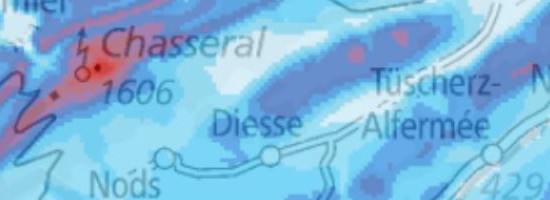
Wind Atlas of Switzerland: Annual average of the modelled wind speed and direction at a height of 150 metres above the ground
The Wind Atlas of Switzerland describes the wind conditions at five different heights above the ground: 50, 75, 100, 125 and 150 metres. The data are based on a nation-wide modelling system with a horizontal grid width of 100 metres. The modelled average annual wind speed is depicted in the atlas at each grid point. The classification of wind speeds into categories can be approximated with the aid of Weibull parameters A (scale parameter) and k (shape parameter). It is not possible to directly derive the average wind speed from the Weibull parameters because the result is only an approximation to wind distribution and this cannot be adequately reflected for each location. The wind rose shows the relative frequency of the modelled wind directions. The averaged wind speeds and corresponding Weibull parameters are visible for each sector. The calculation of wind speeds and directions is based on long-term measurements that have been incorporated into the models. Because the measurement points are not available everywhere throughout the country at a suitable density, and inaccuracies can occur in the modelling of wind flows in complex terrain, the results are subject to uncertainties. These range from +/- 0.5 metres per second in the Jura range, +/- 0.7 metres per second in the central plain and +/- 0.5 metres per second in the pre-Alps, to +/- 1.3 metres per second in the Alps. For maps at heights of more than 100 metres above the ground, significantly fewer measurements are available for modelling purposes, and this leads to increased uncertainties in the results. The data have to be regarded as rough estimates of the wind conditions. To assess the wind conditions at a specific location, measurement on site is therefore essential.
Simple
- Alternate title
-
Wind speed 150 metres above ground
- Date (Creation)
- 2016-02-25T00:00:00
- Date (Revision)
- 2019-10-23
- Identifier
- ch.bfe.windenergie-geschwindigkeit_h150
Point of contact
Spatial resolution
Equivalent scale
- Denominator
- 5000
Spatial resolution
Equivalent scale
- Denominator
- 1000000
- Topic category
-
- Q Utilities communication
Extent
Extent
- Description
-
Switzerland
))

- Maintenance and update frequency
- Unknown
- geocat.ch
-
-
opendata.swiss
-
- GEMET
-
-
renewable energy source
-
wind power
-
- geocat.ch
-
-
FSDI Federal Spatial Data Infrastructure
-
Resource constraints
- Use constraints
- Other restrictions
- Other constraints
- Opendata BY: Open use. Must provide the source.
- Language
- Deutsch
- Character encoding
- UTF8
- Subtopic Category
- Q1 Energy
- Basic Geodata
- false
- Basic Geodata Legal Level
- Federal
- Distribution format
-
-
ESRI File Geodatabase FileGDB (GDB)
-
INTERLIS 2 (XTF)
-
GeoTIFF (GEOTIFF)
-
OGC Geopackage (GPKG)
-
Digital transfer options
- OnLine resource
-
ch.bfe.windenergie-geschwindigkeit_h150
WMS-FSDI service, layer "Wind speed 150 metres above ground"
Digital transfer options
- OnLine resource
-
Geopackage
Geopackage
Digital transfer options
- OnLine resource
-
Filegeodatabase
Filegeodatabase
Digital transfer options
- OnLine resource
-
GeoTIFF
GeoTIFF
Digital transfer options
- OnLine resource
-
Interlis
Interlis
- Geometric object type
- Surface
- Reference system identifier
- EPSG:2056
Metadata
- Metadata identifier
- bb51c6f0-2be5-4933-9582-90dc613c8c75
- Language
- Deutsch
- Character encoding
- UTF8
- Language
- Français
- Character encoding
- UTF8
- Language
- Italiano
- Character encoding
- UTF8
- Language
- English
- Character encoding
- UTF8
- Language
- Rumantsch
- Character encoding
- UTF8
Point of contact
Type of resource
- Resource scope
- Dataset
- Metadata linkage
-
https://www.geocat.ch/geonetwork/srv/api/records/bb51c6f0-2be5-4933-9582-90dc613c8c75
- Date info (Creation)
- 2015-12-02T12:50:09Z
- Date info (Revision)
- 2026-04-13T09:47:51.20782Z
Metadata standard
- Title
-
eCH-0271