geocat.ch
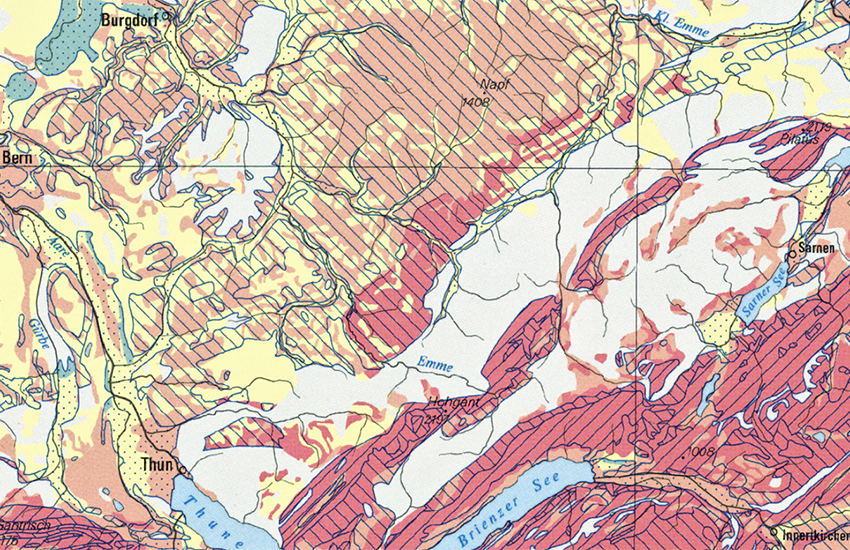
Hydrogeological Map of Switzerland: Vulnerability of Groundwater Resources 1:500000
The Federal Office for the Environment (FOEN) is the body within the Swiss Geological Survey responsible for hydrogeology. The 1:500,000 Hydrogeological Map forms part of the GeoMaps series (GK500) and is divided into two sheets. The first (GK500-Hydro) represents the various groundwater resources in Switzerland and their productivity. The second (GK500-Hydro_Vul) shows the vulnerability of the groundwater resources to the risk of pollution. The principle of vulnerability is an important element of preventive groundwater protection. The two sheets were originally published as Tables 8.6 and 8.7 of the Hydrological Atlas of Switzerland HADES (FOEN, 2004 and 2007).
Simple
- Alternate title
-
Groundwater Vulnerability 500
- Date (Publication)
- 2008-01-01T00:00:00
- Identifier
- ch.swisstopo.geologie-hydrogeologische_karte-grundwasservulnerabilitaet
- Presentation form
- Hardcopy map
- Presentation form
- Digital map
- Name
-
GeoKarten 500
- Status
- Completed
Distributor
Point of contact
Owner
- Spatial representation type
- Grid
- Spatial representation type
- paperMap
Spatial resolution
Equivalent scale
- Denominator
- 500000
- Topic category
-
- F Geoscientific information
Extent
Extent
- Description
-
National Map 1:500'000
- Geographic identifier
- NM500
))

- Maintenance and update frequency
- As needed
- Duration of Conservation
- 275
- Appraisal of Archival Value
- A
- Reason for Archiving Value
- Evidence of business practice
- geocat.ch
-
-
opendata.swiss
-
e-geo.ch
-
official geodata
-
Conservation and archiving planning AAP - Confederation
-
- GEMET
-
-
earth science
-
groundwater protection
-
hydrogeology
-
groundwater endangering
-
- geocat.ch
-
-
FSDI Federal Spatial Data Infrastructure
-
Associated resource
- Title
-
Geological Maps
- Association Type
- Reference to a master resource of which this one is a part
- Language
- Deutsch
- Character encoding
- UTF8
- Language
- Français
- Character encoding
- UTF8
- Supplemental Information
-
Diese Karte ist als Druckversion (gefalzt oder plano) oder Pixelkarte erhältlich.
- Subtopic Category
- F1 Geology
- Basic Geodata
- true
- Basic Geodata ID
-
46.7
- Basic Geodata Legal Level
- Federal
- Distribution format
-
-
analog
-
GeoTIFF (GEOTIFF)
-
ESRI Shapefile (SHP)
-
Digital transfer options
- OnLine resource
-
Vorschau map.geo.admin.ch
Preview map.geo.admin.ch
Digital transfer options
- OnLine resource
-
ch.swisstopo.geologie-hydrogeologische_karte-grundwasservulnerabilitaet
WMS-FSDI service, layer "Groundwater Vulnerability 500"
Digital transfer options
- OnLine resource
-
ch.swisstopo.geologie-hydrogeologische_karte-grundwasservulnerabilitaet
WMTS-FSDI service, layer "Groundwater Vulnerability 500"
Digital transfer options
Digital transfer options
Digital transfer options
Digital transfer options
Digital transfer options
Digital transfer options
- OnLine resource
-
RESTful API von geo.admin.ch
RESTful API from geo.admin.ch
- Reference system identifier
- Referenzsystem entsprechend der zugrundeliegenden topographischen Karte (CH1903)
Metadata
- Metadata identifier
- b8efde6b-7323-4496-aa70-b976ec55cec9
- Language
- Deutsch
- Character encoding
- UTF8
- Language
- Français
- Character encoding
- UTF8
- Language
- Italiano
- Character encoding
- UTF8
- Language
- English
- Character encoding
- UTF8
- Language
- Rumantsch
- Character encoding
- UTF8
Point of contact
Type of resource
- Resource scope
- Dataset
- Metadata linkage
-
https://www.geocat.ch/geonetwork/srv/api/records/b8efde6b-7323-4496-aa70-b976ec55cec9
- Date info (Creation)
- 2009-07-31T12:00:00Z
- Date info (Revision)
- 2026-04-13T09:28:36.595347Z
Metadata standard
- Title
-
eCH-0271