geocat.ch
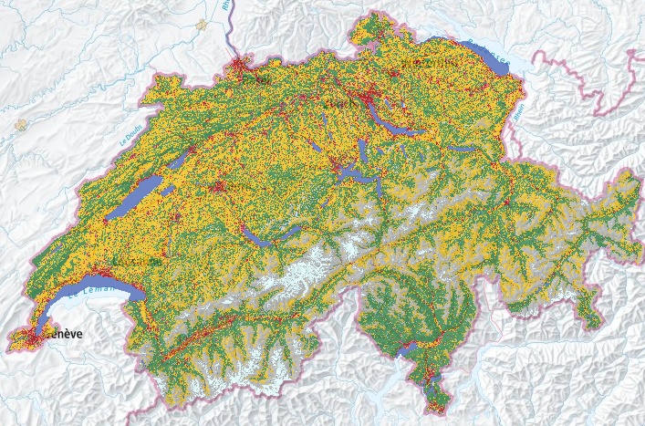
Land use statistics based on the land coverage nomenclature NOLC04
Land cover data in 27 basic categories, obtained by visual interpretation of sample points from a regular 100-metre grid on three-dimensional, digital aerial photographs. The basic categories are visualized here in the form of an aggregation into 10 main categories.
Simple
- Alternate title
-
Land use statistics cover
- Date (Publication)
- 2021-10-20
- Identifier
- ch.bfs.arealstatistik-bodenbedeckung
- Purpose
-
Detaillierte Erhebung der Bodennutzung und -bedeckung der Schweiz mit dem Ziel, deren Zustand und Entwicklung periodisch auszuweisen.
- Status
- On going
Point of contact
Spatial resolution
- Spatial resolution
- 100 m
- Topic category
-
- A Imagery base maps earth cover
Extent
Extent
- Description
-
Switzerland
))

- Maintenance and update frequency
- Annually
Resource format
- Title
-
OGC Geopackage (GPKG)
- Date
Resource format
- Title
-
TEXT, semicolon separated (CSV)
- Date
- GEMET - INSPIRE themes, version 1.0
-
-
Land use
-
Land cover
-
- GEMET
-
-
vegetation
-
- geocat.ch
-
-
FSDI Federal Spatial Data Infrastructure
-
opendata.swiss
-
- GEMET
-
-
aerial photograph
-
- geocat.ch
-
-
opendata.swiss
-
Resource constraints
- Use limitation
-
Freie Nutzung. Quellenangabe ist Pflicht.
- Access constraints
- Intellectual property rights
- Use constraints
- Other restrictions
Associated resource
- Title
-
Arealstatistik der Schweiz
- Association Type
- Reference to a master resource of which this one is a part
- Language
- Deutsch
- Character encoding
- UTF8
- Language
- Français
- Character encoding
- UTF8
- Language
- Italiano
- Character encoding
- UTF8
- Language
- English
- Character encoding
- UTF8
- Supplemental Information
-
Originalresultate aller neueren Arealstatistiken werden bei GEOSTAT in relationalen Datenbanken verwaltet, in welchen jeder Stichprobenpunkt (die für jeden Erhebungszeitpunkt identisch sind) einen Datenrecord darstellt.
- Subtopic Category
- A1 Base Maps, Landscape Models
- Subtopic Category
- A2 Land Cover, Land Use
- Basic Geodata
- true
- Basic Geodata ID
-
12.3
- Basic Geodata Legal Level
- Federal
- Distribution format
-
-
TEXT, semicolon separated (CSV)
-
OGC Geopackage (GPKG)
-
Digital transfer options
- OnLine resource
-
Vorschau map.geo.admin.ch
Digital transfer options
- OnLine resource
-
Variablenliste
Digital transfer options
- OnLine resource
-
ch.bfs.arealstatistik-bodenbedeckung
WMS-FSDI service, layer "Land use statistics cover"
Digital transfer options
- OnLine resource
-
ch.bfs.arealstatistik-bodenbedeckung
WMTS-FSDI service, layer "Land use statistics cover"
Digital transfer options
- OnLine resource
-
Datenbeschreibung
Digital transfer options
- OnLine resource
-
GEOSTAT
GEOSTAT is the centre of competence for geoinformation and digital image processing within the Swiss Federal Statistical Office.
Digital transfer options
- OnLine resource
-
Fachportal: Bodennutzung, -bedeckung
Digital transfer options
- OnLine resource
-
Geodaten
Digital transfer options
- OnLine resource
-
RESTful API von geo.admin.ch
RESTful API from geo.admin.ch
Digital transfer options
- OnLine resource
-
Geodaten
- Statement
-
Visuelle Interpretation von in einem regelmässigen Gitter von 100 m angeordneten Stichprobenpunkten auf digitalen Luftbildern an einer photogrammetrischen Auswertungsstation anhand eines standardisierten Nutzungskatalogs.
- Hierarchy level
- Dataset
- Description
-
Hauptgrundlage für die Bestimmung der Bodennutzung sind eingescannte, digitalisierte Luftbilder des Bundesamts für Landestopografie (swisstopo) der Jahre 1979-85, 1992-97 sowie 2004-09. Zur Qualitätssicherung und Erleichterung der Interpretation werden soweit verfügbar Zusatzinformationen, beispielsweise Landeskarten, Stadtpläne, Gebäudeinformationen des Eidg. Gebäude- und Wohnungsregisters, Schutzgebiete, Naturkatastrophen und dergleichen beigezogen. Nach der Luftbildinterpretation werden ausgewählte und besonders schwierig zu beurteilende Gebiete und Stichprobenpunkte im Gelände aufgesucht und verifiziert (Feldbegehungen). Für die Durchführung reliefabhängiger geometrischer Korrekturen kommt das Geländemodell DHM25 von swisstopo zum Einsatz.
- Reference system identifier
- EPSG:2056
- Maintenance and update frequency
- As needed
- Maintenance note
-
Nachführung erfolgt, wenn Dokumentation fehlerhaft oder verbesserungsbedürftig.
Metadata
- Metadata identifier
- b53c03bb-a168-491f-b266-c7e9ec0af320
- Language
- Deutsch
- Character encoding
- UTF8
- Language
- Français
- Character encoding
- UTF8
- Language
- Italiano
- Character encoding
- UTF8
- Language
- English
- Character encoding
- UTF8
- Language
- Rumantsch
- Character encoding
- UTF8
Point of contact
Type of resource
- Resource scope
- Dataset
- Metadata linkage
-
https://www.geocat.ch/geonetwork/srv/api/records/b53c03bb-a168-491f-b266-c7e9ec0af320
- Date info (Creation)
- 2013-10-17T14:04:50Z
- Date info (Revision)
- 2026-04-13T09:44:46.059901Z
Metadata standard
- Title
-
eCH-0271